Chilton, Texas
Chilton, Texas | |
|---|---|
Census-designated place (CDP) & unincorporated community | |
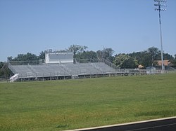 Featherston Field in Chilton | |
 Chilton | |
| Coordinates: 31°16′49″N 97°3′54″W / 31.28028°N 97.06500°WCoordinates: 31°16′49″N 97°3′54″W / 31.28028°N 97.06500°W | |
| Country | |
| State | |
| County | |
| Area | |
| • Total | 3.97 sq mi (10.29 km2) |
| • Land | 3.95 sq mi (10.23 km2) |
| • Water | 0.02 sq mi (0.06 km2) |
| Elevation | 428 ft (130 m) |
| Population (2010) | |
| • Total | 911 |
| • Density | 231/sq mi (89.0/km2) |
| Time zone | UTC-6 (Central (CST)) |
| • Summer (DST) | UTC-5 (CDT) |
| ZIP code | 76632 |
| Area code(s) | 254 |
| FIPS code | 48-14692[1] |
| GNIS feature ID | 1354403[2] |


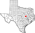
Chilton is a census-designated place (CDP) and unincorporated community in Falls County, Texas, United States. It had a population of 911 at the 2010 census.[1]
It is located in western Falls County. U.S. Route 77 forms the western edge of the community, leading north 20 miles (32 km) to Waco and south 16 miles (26 km) to Rosebud. Texas State Highway 7 passes through the center of Chilton, leading east 10 miles (16 km) to Marlin, the county seat, and west 12 miles (19 km) to Bruceville-Eddy.
The Chilton Independent School District offers extra-curricular activities, most notably football, which is played in the stadium at Featherston Field. In 2006, Chilton won its second 1A state football championship.
External links[]
References[]
- ^ Jump up to: a b "Geographic Identifiers: 2010 Demographic Profile Data (G001): Chilton CDP, Texas". U.S. Census Bureau, American Factfinder. Retrieved August 22, 2016.[dead link]
- ^ U.S. Geological Survey Geographic Names Information System: Chilton, Texas
| show Municipalities and communities of Falls County, Texas, United States |
|---|

| show Authority control |
|---|
 | This article about a location in Falls County, Texas is a stub. You can help Wikipedia by . |
- Unincorporated communities in Texas
- Census-designated places in Falls County, Texas
- Census-designated places in Texas
- Central Texas geography stubs