Chitral
This article needs additional citations for verification. (August 2017) |
Chitral
چترال | |
|---|---|
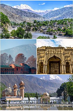 Clockwise from top:
| |
 Chitral | |
| Coordinates: 35°50′46″N 71°47′09″E / 35.84611°N 71.78583°ECoordinates: 35°50′46″N 71°47′09″E / 35.84611°N 71.78583°E | |
| Country | Pakistan |
| Province | Khyber Pakhtunkhwa |
| District | Chitral |
| Government | |
| • Body | Senate of Pakistan |
| • Senator | Falak Naz Chitrali |
| Area | |
| • Total | 57 km2 (22 sq mi) |
| Elevation | 1,494 m (4,902 ft) |
| Population (2017)[2] | |
| • Total | 49,794 |
| • Density | 870/km2 (2,300/sq mi) |
| Languages | |
| • Official | Khowar[3] |
| Time zone | UTC+5:00 (Pakistan Standard Time) |
| PIN | 1720 – 0xx[4] |
| Website | chitral |


Chitral (Pashto/Urdu: چترال, romanized: ćitrāl; Khowar: چھترار, romanized: ćhitrār, lit. 'field') is a town situated on the Chitral River in northern Khyber Pakhtunkhwa, Pakistan. It serves as the capital of the Chitral District and likewise served as the capital of the Chitral princely state that encompassed the region until its direct incorporation into West Pakistan in 1969.
History[]

Early history[]
The Kho Chitralis came to Chitral as part of the Indo-Aryan migration into South Asia. They settled in northern parts of Chitral near the Torkhow and Mulkhow Region.[5]
Ancient era[]
The existence of Gandharan Grave Culture in Chitral, found in various grave sites scattered over its valleys indicate its proximity towards the Gandharan culture alongside giving insightful knowledge of its inhabitants between the Indus Valley civilization era and the following Persian rule.[6][7] Chitral is also associated with the Iron Age tribes known as Daradas. The Darada country stretched from Chitral in the west to the Kisanganga valley in the north of Kashmir. The Daradas are said to have gone to war against Arjun according to the Hindu Epic Mahabharata.[8] Chitral is also attributed to be the seat of the ancient realm of Kamboja, which contains mentions in Hindu epics.[9]
The area which now forms Chitral was reportedly conquered by the Persian Achaemenids and was a part of one of their easternmost satraps. Chitrali culture and vocabulary is heavily influenced by Persian and is said to show a mix of both Avestan and Sanskrit.[10] In the third century CE, Kanishka, the Buddhist ruler of the Kushan empire, occupied Chitral. Under the Kushans, many Buddhist monuments were built around the area, mainly Buddhist stupas and monasteries. The Kushans also patronised Buddhist art, some of the finest examples of the image of Buddha were produced in the region under the Kushan rule.[11]
Rock inscriptions found near the village of Barenis indicate that the area was once part of the Hindu Shahi under its fourth King.[12]
Kator era[]
From 1571 onwards Chitral was the dominion of the Kator Dynasty until 1947.[13]
Accession to Pakistan[]
In 1947 following the division of the British colony of India, princely states were offered the choice to either remain independent or to choose one of the two new dominions. The Mehtar of Chitral who was a friend of Quaid E Azam Mohammad Ali Jinnah acceded to Pakistan and thus Chitral became one of the princely states of Pakistan. In 1969 it was fully integrated into Pakistan as the administrative district of Chitral.[14]
Role in the First Kashmir War[]
Chitral played an instrumental role in the first Kashmir war. Immediately after acceding to Pakistan, Mehtar Muzaffar Ul Mulk proclaimed Jihad to "liberate" Kashmir from the Dogras. At this point, the Gilgit scouts were retreating and the Dogra forces had made gains in the Burzil pass. Under these circumstances, the Chitral scouts relieved the Gilgit scouts in Domel and Kamri sectors whilst the Chitral Bodyguard force went towards Skardu. The Chitral bodyguards under the leadership of a Chitral Prince lay on the longest sieges of military history which ended with the fall of Skardu, surrender of the Dogras and the capture of Baltistan. During this time, the Chitral scouts assimilated with the Gilgit scouts and went on towards taking the Kargil pass.[15]
Geography[]
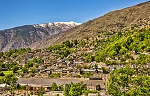
The city has an average elevation of 1,500 m (4,921 ft).
Climate[]
Chitral has a Mediterranean climate (Köppen Csa), with warm summers and cold winters, with heavy snowfall occurring routinely in Chitral Valley. Coldspells that have swept across Chitral can be deadly as locals have died of the extreme numbing temperatures in the past. Chitral is known for snowfall and deadly avalanches. The road that goes towards Chitral is very dangerous as it's one of the most narrow roads in the world, and it is situated in the world's largest mountain range. It is designed to be a one lane road but it is used as a two-lane road. The route is very unstable, without any safety and faces extreme glaciers where temperatures can plummet to -30.0C
| hideClimate data for Chitral | |||||||||||||
|---|---|---|---|---|---|---|---|---|---|---|---|---|---|
| Month | Jan | Feb | Mar | Apr | May | Jun | Jul | Aug | Sep | Oct | Nov | Dec | Year |
| Average high °C (°F) | 8.3 (46.9) |
9.5 (49.1) |
14.9 (58.8) |
21.0 (69.8) |
25.6 (78.1) |
31.8 (89.2) |
32.8 (91.0) |
32.0 (89.6) |
28.7 (83.7) |
23.7 (74.7) |
17.4 (63.3) |
10.9 (51.6) |
21.4 (70.5) |
| Daily mean °C (°F) | 4.1 (39.4) |
5.0 (41.0) |
9.8 (49.6) |
15.3 (59.5) |
19.4 (66.9) |
24.9 (76.8) |
26.1 (79.0) |
25.4 (77.7) |
21.9 (71.4) |
17.0 (62.6) |
11.5 (52.7) |
6.5 (43.7) |
15.6 (60.0) |
| Average low °C (°F) | 0.0 (32.0) |
0.6 (33.1) |
4.8 (40.6) |
9.7 (49.5) |
13.3 (55.9) |
18.0 (64.4) |
19.5 (67.1) |
18.8 (65.8) |
15.2 (59.4) |
10.3 (50.5) |
5.6 (42.1) |
2.1 (35.8) |
11.4 (52.5) |
| Average precipitation mm (inches) | 33 (1.3) |
48 (1.9) |
94 (3.7) |
102 (4.0) |
41 (1.6) |
10 (0.4) |
6 (0.2) |
7 (0.3) |
10 (0.4) |
24 (0.9) |
13 (0.5) |
30 (1.2) |
418 (16.4) |
| Source: Climate-Data.org[16] | |||||||||||||
Demographics[]
According to the 1981 census, Khowar is the main language and is spoken by 98% of the population. Kalasha is also spoken by a small population.[17]
Administration[]
Chitral is represented in the Senate of Pakistan by Mrs. Falak Naz Chitrali (Selected in March 2021) and Provincial Assembly by one minority representative Mr. Wazir Zada from Kalasha Community.
See also[]
References[]
- ^ Ahmada, Munir; Muhammadb, Dost; Mussaratb, Maria; Naseerc, Muhammad; Khand, Muhammad A.; Khanb, Abid A.; Shafi, Muhammad Izhar (2018). "Spatial variability pattern and mapping of selected soil properties in hilly areas of Hindukush range northern, Pakistan". Eurasian Journal of Soil Science. 7 (4): 355. doi:10.18393/ejss.466424. Retrieved 29 August 2019 – via dergipark.org.tr.
- ^ https://www.citypopulation.de/en/pakistan/admin/khyber_pakhtunkhwa/606__chitral/
- ^ "INDO-IRANIAN FRONTIER LANGUAGES". Encyclopaedia Iranica. 15 November 2006. Retrieved 6 November 2015.
- ^ "Post Codes". Pakistan Post Office. Retrieved 17 March 2015.
- ^ "Languages of Chitral" (PDF).
- ^ Schug, Gwen Robbins; Walimbe, Subhash R. (13 April 2016). A Companion to South Asia in the Past. John Wiley & Sons. ISBN 978-1-119-05547-1.
- ^ "Mera Chitral: History of chitral". Mera Chitral. Retrieved 1 February 2020.
- ^ Saklani, Dinesh Prasad (1998). Ancient Communities of the Himalaya. Indus Publishing. ISBN 978-81-7387-090-3.
- ^ Proceedings and Transactions of the ... All-India Oriental Conference ... etc. 1933.
- ^ Notes on Chitral. L.D. Scott. 1903.
- ^ Gurdon's Report on Chitral. Gurdon. 1903.
- ^ Khan, Hussain (June 2003). Chronicles of Early Janjuas. iUniverse. ISBN 978-0-595-28096-4.
- ^ "Chitral, a Study in Statecraft" (PDF). IUCN. Retrieved 6 November 2015.
- ^ Osella, Filippo; Soares, Benjamin (2010). Islam, Politics, Anthropology. John Wiley & Sons. p. 58. ISBN 978-1-4443-2441-9.
- ^ "Full text of "An Illustrated History of Chitral Scouts 1900-2015"". archive.org. Retrieved 2 February 2020.
- ^ "Climate: Chitral". Climate-Data.org. Retrieved 18 November 2017.
- ^ "Population Demography". Kpktribune.com. Archived from the original on 28 December 2017. Retrieved 18 November 2017.
Bibliography[]
- Decker, D. Kendall (1992). Languages of Chitral. ISBN 4871875202.
- Durand, Col. A. (1899). The Making of a frontier.
- Leitner, G. W. (1893). Dardistan in 1866, 1886 and 1893: Being An Account of the History, Religions, Customs, Legends, Fables and Songs of Gilgit, Chilas, Kandia (Gabrial) Yasin, Chitral, Hunza, Nagyr and other parts of the Hindukush, as also a supplement to the second edition of The Hunza and Nagyr Handbook. And An Epitome of Part III of the author's The Languages and Races of Dardistan (First reprint ed.). New Delhi: Manjusri Publishing House. ISBN 4871877787.
Further reading[]
- Allan, Nigel J. R.; Buddruss, Georg (1991). "CHITRAL". Encyclopaedia Iranica, Vol. V, Fasc. 5. pp. 487–494.
External links[]
| Wikivoyage has a travel guide for Chitral. |
| Wikimedia Commons has media related to Chitral (town). |
- Official website
- Government of Khyber-Pakhtunkhwa
- Khyber-Pakhtunkhwa Government website section on Lower Dir
- United Nations
| show Administrative divisions of Chitral District |
|---|
| show Authority control |
|---|
- Chitral
- Chitral District
- Tehsils of Chitral District
- Union councils of Khyber Pakhtunkhwa
- Populated places in Chitral District
- Union councils of Chitral District
- Hill stations in Pakistan
- Populated places along the Silk Road