Chiusella
| Chiusella | |
|---|---|
 | |
 Location within the province of Turin | |
| Location | |
| Country | Italy: province of Turin |
| Physical characteristics | |
| Source | |
| • location | Monte Marzo |
| • elevation | around 2,300 m (7,500 ft) |
| Mouth | Dora Baltea |
• coordinates | 45°24′10″N 7°54′54″E / 45.40278°N 7.91500°ECoordinates: 45°24′10″N 7°54′54″E / 45.40278°N 7.91500°E |
• elevation | 223 m (732 ft)[1] |
| Length | 41.2 km (25.6 mi)[2] |
| Basin size | 212.9 km2 (82.2 sq mi)[3] |
| Discharge | |
| • average | (mouth) 6.1 m3/s (220 cu ft/s)[3] |
| Basin features | |
| Progression | Dora Baltea→ Po→ Adriatic Sea |
| Tributaries | |
| • left | rio Dondogna, torrente Tarva, torrente Bersella, rio Quaglia, rio Ribes |
| • right | rio Sportore, rio Ricordone, rio Trueisa, torrente Savenca |

The Chiusella (Piedmontese: Ciusèila) is a 41-kilometre (25 mi) long creek in the Piedmont region of Italy.
Geography[]

The Chiusella starts in the Graian Alps near Mount Marzo and Bocchetta delle Oche, a mountain pass connecting its valley with . Flowing initially from NW to SE it reaches Traversella and the permanently inhabited part of the valley. In the territory of Issiglio it receives from the right side the waters of Torrente Savenca, its main tributary. The Chiusella is then blocked by a dam forming the . Flowing eastwards it forms a canyon and leaves the mountains entering the plain; near Strambino it finally flows into the Dora Baltea.[1]
Tributaries[]
- Left hand tributaries:
- torrente Dondogna;
- torrente Tarva;
- torrente Bersella;
- rio Quaglia;
- rio Ribes (formerly Ri Bes).
- Right hand tributaries:
- rio Sportore;
- rio Ricordone;
- rio Trueisa;
- torrente .
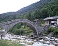
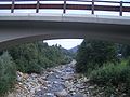
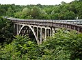
The bridges on the Chiusella[]

The bridge of the Chiara village (high Chiusella valley)
Fondo Valchiusella bridge
The Chiusella behind Inverso bridge
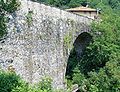
An 18th-century bridge named Ponte dei Preti (Strambinello)
Former national road nr.565 between Strambinello and Baldissero Canavese
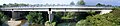
The bridge of the national road nr.26 near Romano Canavese


References[]
- ^ a b Carta Tecnica Regionale raster 1:10.000 (vers.3.0) of Regione Piemonte - 2007
- ^ AA.VV. (2004). "Elaborato I.c/5". Piano di Tutela delle Acque - Revisione del 1º luglio 2004; Caratterizzazione bacini Idrografici (PDF). Regione Piemonte. Archived from the original (PDF) on 2012-02-25. Retrieved 2013-01-28.
- ^ a b AA.VV. (2004). "Elaborato I.c/7". Piano di Tutela delle Acque - Revisione del 1º luglio 2004; Caratterizzazione bacini Idrografici (PDF). Regione Piemonte. Archived from the original (PDF) on 2012-02-25. Retrieved 2013-01-28.
Other projects[]
![]() Media related to Chiusella at Wikimedia Commons
Media related to Chiusella at Wikimedia Commons
- Tributaries of the Dora Baltea
- Rivers of the Province of Turin
- Rivers of the Alps
- Rivers of Italy