Chocolate Mountain Aerial Gunnery Range
| Chocolate Mountain Aerial Gunnery Range | |
|---|---|
| Part of | |
| Imperial County and Riverside County, California Near Brawley, California | |
 Map of the Chocolate Mountain Aerial Gunnery Range | |
| Coordinates | 33°18′N 115°18′W / 33.3°N 115.3°W
 |
| Type | Bombing range |
| Site information | |
| Controlled by | |

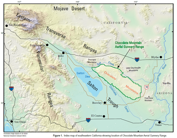
The Chocolate Mountain Aerial Gunnery Range (CMAGR), is a 459,000 acres (1,860 km2)[1] open-area, approximately 20 miles wide, east to west, and 50 miles long, northwest to southeast, with a special use airspace of 700 square miles (1,800 km2)[1] which is used for aerial bombing and live fire aerial gunnery practice. It straddles the northern portion of the Chocolate Mountains to the east of the Salton Sea in Imperial and Riverside Counties, California, with restricted airspace in both California and Arizona. It is under the jurisdiction of the United States Navy and United States Marine Corps, and is closed to the public.
The United States Department of Defense aviation combat crews have trained at the CMAGR and within its airspace since World War II.[1] The range is managed by Marine Corps Air Station Yuma.[1] The CMAGR range area was permanently transferred to the Department of the Navy in 2014 to be used as a military range.[1] The CMAGR provides opportunities for military training by use of its varied terrain and special use airspace.[1] The CMAGR is the centerpiece of the Bob Stump Training Range Complex and can support multiple training operations concurrently.[1] The CMAGR's live-fire aviation training ranges provide training for air combat maneuvering and tactics; air-to-air gunnery; airborne laser system operations; close air support; and air-to-ground bombing, strafing, and rocketry.[1] The CMAGR also supports ground training to include air defense, air control, communications, demolition operations, as well as the support of small arms and artillery.[1] The Naval Special Warfare Command also use a portion of the CMAGR for desert warfare training.[1]
The Bradshaw Trail, an old stage road and now a four wheel drive vehicle road, traverses the north boundary of the Gunnery Range between the Chocolate Mountains and the Orocopia Mountains and Chuckwalla Mountains to the north.[2]
The Navy and Marine Corps jointly prepared and published a "Geologic Map and Database of the Chocolate Mountain Aerial Gunnery Range" in 2018.[3]
Gallery[]

U.S. Navy S-2E Tracker from Anti-Submarine Squadron 37 carrying a four-rocket pod of Zuni 127 mm Folding-Fin Aircraft Rockets below its port wing over the Chocolate Mountain Aerial Gunnery Range (1970)

U.S. Navy F-8J Crusaders drop bombs at Chocolate Mountain Aerial Gunnery Range (1972)
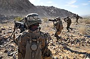
A fire team from the 2nd Marine Regiment advance toward their downed targets, wrapping up a live-fire ambush and reaction drill at Camp Billy Machen Desert Warfare Training Facility, Chocolate Mountain Aerial Gunnery Range (2009)

Marine Wing Support Squadron 374 heavy equipment operators remove dirt from and level an unmanned aircraft system runway at the Chocolate Mountain Aerial Gunnery Range (2009)

Test services maintenance crewman weld the support brace of a fake radar dish on the top of a target shaped like a radar van at the Chocolate Mountain Aerial Gunnery Range (2010)

Steel targets simulating Afghan insurgents stand at the Al Brutus training complex within target area 15 North in the Chocolate Mountain Aerial Gunnery Range (2011)

Marines supporting Weapons and Tactics Instructors (WTI) Course 1-14, participate in a CH-53E Super Stallion sling loading exercise at Landing Zone Bull on the Chocolate Mountain Aerial Gunnery Range (2013)

A field radio operator with 9th Communications Battalion, participating in WTI 2-13, uses a laser target designator at the Chocolate Mountain Aerial Gunnery Range (2013)
Marines practicing air assault support tactics at the Chocolate Mountain Aerial Gunnery Range (2019)


References[]
- ^ Jump up to: a b c d e f g h i j Chocolate Mountain Aerial Gunnery Range: California, The Western Regional Partnership, Military Asset List 2016, U.S. Marine Corps, dated 2016, last accessed 12 July 2020.
 This article incorporates text from this source, which is in the public domain.
- ^ California Atlas & Gazeteer, DeLorme, 4th ed., 2015, p. 152-3 ISBN 0899333834
- ^ Open-File Report 2018-1191
External links[]
| Wikimedia Commons has media related to Chocolate Mountain Aerial Gunnery Range. |
- Profile on GlobalSecurity.org
- Final Legislative Environmental Impact Statement for the Renewal of the Chocolate Mountain Aerial Gunnery Range Land Withdrawal Naval Facilities Engineering Command Southwest
- U.S. Geological Survey Geographic Names Information System: Chocolate Mountain Aerial Gunnery Range
| show Operational military installations in California |
|---|


| Authority control |
|
|---|
- Installations of the United States Navy in California
- Geography of Imperial County, California
- Military in Riverside County, California