Chyah
Chiyah | |
|---|---|
 Flag |
This article does not cite any sources. (March 2016) |
Chiyah (Arabic: الشياح) is situated in the west region of the Lebanese capital of Beirut and is part of Greater Beirut.
Location[]
Chiyah is located in the southwest suburbs of the capital Beirut, bordered by Haret Hreik, Ghobeiry, Hadath, Hazmiyeh, Furn-el-chebbak and Ain El Remmaneh. However, before 1956, it used to cover a larger area that included the current districts of Karm el Zeitoun, Hayy el Knissé, Bir Abed and Haret el Mjadlé, as well as Jnah, Ghobeiry, Furn-el-chebbak, Bir Hassan and Ain El Remanneh.
The meaning of its name is vague, and many suppositions were found, with one saying that it means the processing of metal (Shewah). Another theory is the Arabic origin of the name means a kind of tree that is used for silk production (a flourishing industry in this former village). The city was once covered with citrus orchards and extending to the Mediterranean Sea. Today, it is a full part of the demographically huge Beirut outskirts totalling around 60,000 inhabitants.
Demographics[]
Historically, Chiyah was a predominately Christian town, but it became partly inhabited by Shia Muslims. The major surnames or families in Chyah are Rahme, Nasr, Srouji, Maarouf, Kassem, Kanj, Farraj, Sous, and El-Khatib.
History[]
During the Ottoman period, Chiyah used to be ruled by the Druze Arslan family, but later it was passed on to the Shihab dynasty.
The current head of the municipality is parliament member hopeful . headed the municipality for the time of the parliamentary elections. Naji Gharios, a native of Chiyah, was elected in June 2009 as member of the Lebanese Parliament representing the Baabda district.
See also[]
External links[]
- Chiyah, Localiban
Coordinates: 33°51′43″N 35°30′49″E / 33.86194°N 35.51361°E

| First-level administrative divisions | |
|---|---|
| List of cities |
|
Capital: Baabda | ||
| Towns and villages | 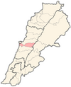 | |
This Lebanon location article is a stub. You can help Wikipedia by . |
- Greater Beirut
- Populated places in Baabda District
- Maronite Christian communities in Lebanon
- Shia Muslim communities in Lebanon
- Populated places in Lebanon
- Lebanon geography stubs