Climax, Saskatchewan
Climax | |
|---|---|
Village | |
| Village of Climax | |
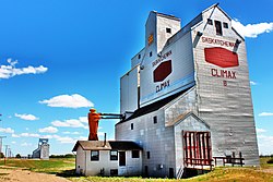 Grain elevators along the railway tracks in Climax. | |
 Climax | |
| Coordinates: 49°12′23″N 108°23′10″W / 49.2064°N 108.386°W | |
| Country | Canada |
| Province | Saskatchewan |
| Region | Southwest |
| Census division | 4 |
| Rural Municipality | Lone Tree |
| Post office Founded | 1913[1] |
| Government | |
| • Type | Municipal |
| • Governing body | Climax Village Council |
| • Mayor | Dennis Klein |
| • Administrator | Shawna-Lee Bertram[2] |
| • MP | Jeremy Patzer |
| • MLA | Doug Steele |
| Area | |
| • Total | 1.00 km2 (0.39 sq mi) |
| Population (2016) | |
| • Total | 195 |
| • Density | 195.8/km2 (507/sq mi) |
| Time zone | UTC-6 (CST) |
| Postal code | S0N 0N0 |
| Area code(s) | 306 |
| Highways | |
| Railways | Great Western Railway |


Climax (2016 population: 195) is a village in the Canadian province of Saskatchewan within the Rural Municipality of Lone Tree No. 18 and Census Division No. 4. The village is located in the southwestern region of the province, just north of the U.S. border, situated on Highway 18 between Frontier and Canuck and on Highway 37 between Shaunavon and the Port of Climax.
History[]
Climax incorporated as a village on December 11, 1923.[3] The community was named after Climax, Minnesota, the home town of early homesteader Christ Fuglestad.[1]
Demographics[]
In the 2016 Census of Population conducted by Statistics Canada, the Village of Climax recorded a population of 195 living in 93 of its 113 total private dwellings, a 6.7% change from its 2011 population of 182. With a land area of 1 km2 (0.39 sq mi), it had a population density of 195.0/km2 (505.0/sq mi) in 2016.[6]
In the 2011 Census of Population, the Village of Climax recorded a population of 182, a 0% change from its 2006 population of 182. With a land area of 1 km2 (0.39 sq mi), it had a population density of 182.0/km2 (471.4/sq mi) in 2011.[7]
Notable people[]
- Willie Desjardins, former head coach of the Vancouver Canucks.[8]
- Gord Kluzak, former NHL ice hockey player (1982-1991)
See also[]
- List of communities in Saskatchewan
- Villages of Saskatchewan
References[]
- ^ a b Barry, Bill (September 2005). Geographic Names of Saskatchewan. Regina, Saskatchewan: People Places Publishing, Ltd. p. 87. ISBN 1-897010-19-2.
- ^ Municipal Directory System
- ^ "Urban Municipality Incorporations". Saskatchewan Ministry of Government Relations. Archived from the original on October 15, 2014. Retrieved June 1, 2020.
- ^ "Saskatchewan Census Population" (PDF). Saskatchewan Bureau of Statistics. Archived from the original (PDF) on September 24, 2015. Retrieved May 31, 2020.
- ^ "Saskatchewan Census Population". Saskatchewan Bureau of Statistics. Retrieved May 31, 2020.
- ^ "Population and dwelling counts, for Canada, provinces and territories, and census subdivisions (municipalities), 2016 and 2011 censuses – 100% data (Saskatchewan)". Statistics Canada. February 8, 2017. Retrieved May 30, 2020.
- ^ "Population and dwelling counts, for Canada, provinces and territories, and census subdivisions (municipalities), 2011 and 2006 censuses (Saskatchewan)". Statistics Canada. June 3, 2019. Retrieved May 30, 2020.
- ^ "Vancouver Canucks fire coach Willie Desjardins, who becomes fall guy for foundering franchise". National Post. Retrieved 2017-04-11.
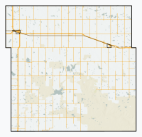
Places adjacent to Climax, Saskatchewan | ||||||||||||||||
|---|---|---|---|---|---|---|---|---|---|---|---|---|---|---|---|---|
| ||||||||||||||||
| Subdivisions | |
|---|---|
| Communities |
|
| Cities |
|
| Villages |
|
| Topics |
|
| |

Coordinates: 49°12′23″N 108°23′10″W / 49.2064°N 108.386°W
This article about a location in the Census Division No. 4 of Saskatchewan is a stub. You can help Wikipedia by . |
- Villages in Saskatchewan
- Lone Tree No. 18, Saskatchewan
- Division No. 4, Saskatchewan
- Saskatchewan geography stubs