Collón Curá River
| Collón Curá River | |
|---|---|
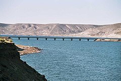 Bridge over the Collón Curá River | |
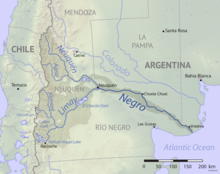 Map of the Río Negro watershed with the Collón Curá River indicated | |
| Native name | Río Collón Curá Error {{native name checker}}: parameter value is malformed (help) |
| Location | |
| Country | Argentina |
| Province | Neuquén |
| Physical characteristics | |
| Source | |
| • coordinates | 39°57′48″S 71°04′32″W / 39.96333°S 71.07556°WCoordinates: 39°57′48″S 71°04′32″W / 39.96333°S 71.07556°W |
| • elevation | 970 m (3,180 ft) |
| Mouth | Limay River |
| Length | 70 km (43 mi) |
| Basin features | |
| River system | Río Negro |

The Collón Curá River is a geographical feature of Neuquén Province, Argentina. It flows southward from the confluence of the Aluminé and Chimehuin Rivers, near the town of Junín de los Andes, for around 70 kilometres (43 mi), past which it becomes a tributary of the Limay River. The Collón Curá Formation and in turn the South American land mammal age Colloncuran are named after the river.
The valley is famous for its two activities: birdwatching and fly fishing.
See also[]
References[]
- Rand McNally, The New International Atlas, 1993.
- GEOnet Names Server Archived 2020-04-10 at the Wayback Machine
This article about a place in Neuquén Province, Argentina is a stub. You can help Wikipedia by . |
This article related to a river in Argentina is a stub. You can help Wikipedia by . |
Categories:
- Rivers of Neuquén Province
- Mapuche language
- Rivers of Argentina
- Neuquén Province geography stubs
- Argentina river stubs