Colonia del Valle
This article relies too much on references to primary sources. (August 2011) |
Colonia del Valle | |
|---|---|
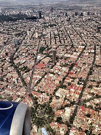 Aerial view of Colonia Del Valle. At bottom, the park at the junction of Division Del Norte, Eje 3 Poniente Amores, San Antonio and Ave. Colonia Del Valle. In background, Condesa (left) and Roma (right) districts and the Paseo de la Reforma skyline. In the middle, the Torre AXA México, formerly Mexicana Tower. | |
 Del Valle neighborhood is located in the Benito Juarez borough. (Map showing location of the borough within Mexico City) | |
| Country | |
| City | Mexico City |
| Borough | Benito Juárez |
| Website | http://www.coloniadelvalle.com.mx |


Colonia del Valle (Spanish for: Del Valle neighborhood) is a neighborhood in the Benito Juarez borough of Mexico City.[1] It includes "...a great number of parks, vast and tree-lined streets, prestigious shopping malls, and some city landmarks...".[2]
Del Valle is bounded by the streets of:
- Viaducto Miguel Alemán to the north,
- Cuauhtémoc and Universidad to the east,
- Rio Mixcoac - Barranca del Muerto to the south and
- Insurgentes Avenue to the west.
Adjacent neighborhoods include
- Colonia Nápoles, Ciudad de los Deportes, Noche Buena and San Borja to the west,
- Escandón to the northwest,
- Colonia Roma Sur and Piedad Narvarte to the north,
- Colonia Narvarte, Vértiz Narvarte and Letrán Valle to the east, and
- Tlacomecatl del Valle, Miguel Alemán, Xoco and Santa Cruz Atoyac to the south.[3]
History[]
At the beginning of the 20th century the ranches cultivated with alfalfa and fruit trees were divided, giving rise to Colonia Americana. Some neighborhood streets are named after these ranches and their fruit trees, others after Mexican philanthropists.
While serving as a streetcar route from Mexico City to Coyoacán it developed slowly until 1920, when it expanded and the Avenida de los Insurgentes was paved. Large-scale home and mansion construction started. The area also featured monument construction and green areas; one is the Paque Hundido, built on a former sand mine.
In the 1960s the area was as fully developed as many other neighborhoods of equal purchasing power on its borders. Commercial development included two major facilities, Liverpool Insurgentes opening in 1962 and the country's first shopping center, University Plaza, in 1969.
In 1978 the city built the Ejes viales, a system of wide, one-way roads criss-crossing the city, and with this Del Valle was transformed radically and permanently, its tree-lined boulevards with green medians transformed into quasi-freeways. Ejes 4, 5, 6, 7 and 8 south crossed from east to west and 1, 2 and 3 from south to north. This drove many families to look for a quieter place to live and began the process of redeveloping the area. Mansions were replaced by apartment buildings, offices or schools.
Crime statistics from 2009 showed that Colonia del Valle was the second most crime-ridden neighborhood in Mexico City, sharing the top 10 list with notorious neighborhoods Tepito and Colonia Doctores.[4] However, 2012 statistics do not place Del Valle on the list of the top 6 most crime-ridden neighborhoods.[5]
Transportation[]
Major roads running through the neighborhood include: Insurgentes, Cuauhtemoc, Northern Division, University, Félix Cuevas, José María Rico, Xola.[citation needed] Mexico City Metro Line 3 has several stations in the vicinity: Etiopía, Eugenia, División del Norte, Zapata and Coyoacán. Mexico City Metrobús (BRT) Line 3 stops at Amores (corner of Xola).
Architecture[]
The architecture includes large mansions in Californian mission revival Art Deco style and, to a lesser extent, surviving examples of Porfiriato. At the end of the 1960s many small skyscrapers, both commercial and residential, were built, making the area one of the most densely populated of Mexico City. Housing complexes were also built.[citation needed]
It houses churches such as the Temple of the Immaculate Heart of Mary, and buildings dating from the period of colonization and conquest between park Tlacoquemécatl including the Temple of San Lorenzo and the Xochimanca, cultural areas and parks like the Sunken Park or Mariscal Sucre Park, the French Kiosk, art galleries, libraries, auditoriums Polyforum Cultural Siqueiros, Plaza México, and Estadio Azul stadium.
Religious buildings[]
The religious structures found in the Del Valle include the Templo del Purísimo Corazón de María (Parish of the Most Pure Heart of Mary) at the corner of Gabriel Mancera number 415. It was built in the early 20th century. In 1996 several scenes of the film Romeo + Juliet were filmed at the church. Mexican singer Luis Miguel was baptized there.[citation needed]
The Temple of San Lorenzo Xochimanca, located in the park of the same name a.k.a. Parque Popular, was built in the 16th century.[6]
The Parroquia del Señor del Buen Despacho, located in Parque Tlacoquemécatl, dates from the 18th century.[7] The Temple of Santo Tomás Actipan, built in 1897, is located at the corner of Bufalo and Tigre streets.
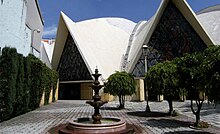
The Temple of Santa Monica, with the signature "cáscaro" thin-shell structure of its architect Félix Candela, on Fresa Street opposite the park of San Lorenzo, was built in 1962. The Parish of Divine Providence in Adolfo Prieto street was constructed between 1968 and 1974.[citation needed]
Education[]
Within the Del Valle are two of the oldest educational institutions in the country; the College and Institute of Mexico and its Centro Universitario Mexico, and the Colegio Simón Bolívar. Graduates of these schools include Octavio Paz and Germán Dehesa.[citation needed]
International schools include:
Colegio Nuevo Continente
Tomas Alva Edison
Notable people[]
- Helena Espinosa Berea (ca.1895 - ca.1960), Mexican academic
- María Ernestina Larráinzar Córdoba (1854-1925), Mexican writer, novelist, teacher, religious order founder
References[]
- ^ "Mapa de la delegación Benito Juárez y la colonia Del Valle" (in Spanish). El Universal. July 2010. Archived from the original on 30 May 2011. Retrieved 5 August 2011.
- ^ "Colonia del Valle". Ciudaddemexico.com.mx (in Spanish). Retrieved 4 August 2011.
...es conocida por su gran cantidad de parques, sus amplias y arboladas calles, sus prestigiosos centros comerciales y algunos símbolos de la ciudad...
- ^ "Ubicacion" (in Spanish). Guía Roji. Archived from the original on 24 April 2012. Retrieved 5 August 2011.
- ^ Ledezma, Hector (April 3, 2009). "Del Valle, de las 10 colonias más inseguras del DF" [Del Valle, one of the 10 most unsafe colonias in Mexico City] (in Spanish). Archived from the original on 28 April 2012. Retrieved 12 May 2012.
- ^ Miguel Á. Morales (2013-07-08), "Las 6 zonas más inseguras del DF" [The 6 most unsafe areas in Mexico City], Más por Más (in Spanish), retrieved 2013-10-07
- ^ "Archived copy". Archived from the original on 2014-05-03. Retrieved 2014-06-24.CS1 maint: archived copy as title (link)
- ^ ""Parroquia del Señor del Buen Despacho", SECTUR DF". Mexicocity.gob.mx. Archived from the original on 3 March 2016. Retrieved 26 July 2018.
External links[]
- Colonia del Valle on the Internet (in Spanish)
Coordinates: 19°23′21″N 99°10′04″W / 19.389164°N 99.167668°W

- Benito Juárez, Mexico City
- Neighborhoods in Mexico City