San Pedro de los Pinos
San Pedro de los Pinos | |
|---|---|
 Californian style house in San Pedro de los Pinos | |
 Location of San Pedro de los Pinos (in red) within Benito Juárez borough | |
| Country | |
| City | |
| Borough | Benito Juárez |
| Postal code | 03800 |
San Pedro de los Pinos is a neighborhood located in center-west of Mexico City. Before being urbanized during the first half of the 20th century, the colonia was part of a vast farming area belonging to several ranches and haciendas.
Location[]
San Pedro de los Pinos is located in the Benito Juárez borough of Mexico City.
The neighborhood is bordered by:[1][2]
- 11 de abril street on the north, across which is Tacubaya, in the Miguel Hidalgo borough
- Calle 2 street on the northwest, across which is Colonia 8 de agosto
- Anillo Periférico on the west, across which is the Álvaro Obregón borough
- Río Becerra on the south and east, across which is Santa María Nonoalco on the south, and Colonia Nápoles and Colonia Ampliación Nápoles on the east
Description[]
San Pedro de los Pinos is a mixed neighborhood with both residential and commercial buildings. Most of the residential buildings date back to the first half of the 20th century, though new apartment buildings are being built in the zone.
The neighborhood has a wide variety of entertainment and commercial buildings, including hotels, restaurants, banks, cafés and gymnasiums.
The colonia has two public parks: Parque Pombo and Parque Miraflores.
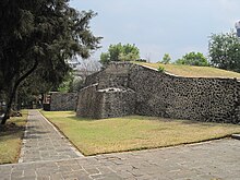
In the southern part of San Pedro de los Pinos there is an archaeological site dating to the Mesoamerican postclassic period, known simply as Mixcoac archaeological zone. In this same area, there is a cultural center named "La Pirámide" (the pyramid), where several artistic and sports activities take place.
History[]
The area was already populated since pre-Columbian era as shown by the Mixcoac archaeological site.
During 17th and 18th century, several ranches and haciendas were established here, as well as a bartizan, the bartizan of San Pedro, which was in the middle of the route going from the center of Mexico City towards Mixcoac or San Ángel in the south. The soil here was very fertile, thus, having plenty of groves, mainly pines. Hence the name San Pedro de los Pinos.[3]
Transportation[]
Public transportation[]
The area is served by the Mexico City Metro and EcoBici bikeshare. Although not in the neighborhood proper, San Antonio metro station is within walking distance.
Metro stations
 San Pedro de los Pinos.
References[]
- ^ (in Spanish) "Nuestra Demarcación" (Our borders), Delegación Benito Juárez website, archive of 2013-08-12
- ^ (in Spanish) Mapa de colonias de la Delegación Benito Juárez (Map of colonias of the Benito Juárez borough
- ^ San Pedro de los Pinos (in Spanish), Sistema de Transporte Colectivo, retrieved May 31, 2018
Further reading[]
- Pensado Leglise, María Patricia; Real García Figueroa, María de Jesús (2003). Historia oral de San Pedro de los Pinos: conformación y transformación del espacio urbano en el siglo XX (in Spanish). Mexico City: Instituto Mora. Delegación Benito Juárez. Consejo de la Crónica de la Ciudad de México. ISBN 9789706840844.
| Areas | |
|---|---|
| Schools |
|
| Universities | |
| Mexico City Metro stations | |
| Landmarks |
|
| |
- Benito Juárez, Mexico City