Colorado State Highway 105
 | ||||
|---|---|---|---|---|
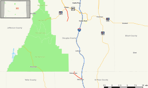 Map of central Colorado with SH 105 highlighted in red | ||||
| Route information | ||||
| Maintained by CDOT | ||||
| Length | 33.09 mi[1] (53.25 km) | |||
| Major junctions | ||||
| East end | Jackson Creek Parkway near Monument | |||
| North end | ||||
| Location | ||||
| Counties | El Paso, Douglas | |||
| Highway system | ||||
Colorado State Highways
| ||||
State Highway 105 (SH 105) is a state highway that runs partially from I-25 in Monument to SH 67 (Manhart Avenue) in Sedalia. The highway serves the communities of Monument and Palmer Lake and the unincorporated areas of Douglas and El Paso counties. Several former sections have been deleted from the state highway system since its inception, thus leading to north and south sections of the current highway.
Route description[]

The road begins at State Highway 83 and maneuvers west where it reaches Interstate 25 with a complex interchange and begins heading westward through the city of Monument. The road then abruptly turns northward and northwestward, nearing Palmer Lake. Once past the lake, the road begins northward along Spruce Mountain Road, turning abruptly westward onto Perry Park Road, abruptly ending at the El Paso - Douglas county line, where it becomes Douglas County Road 105. The road moves through the foothills of Douglas County as Perry Park Road and resumes as State Highway 105 at Wolfsenberger Road. It then heads westward to its terminus at SH 67 near Sedalia.[1]
History[]
The route was established in the 1920s, when it connected U.S. Highway 87, now Interstate 25, to Sedalia. By 1963, the road was deleted from Palmer Lake to Interstate 25 and the road was paved to its entirety. The road was extended to replace SH 50 (now deleted) due to confusion with U.S. Highway 50. A section from SH 83 to I-25 was deleted in October 2007.[2]
Major intersections[]
| County | Location | mi | km | Destinations | Notes |
|---|---|---|---|---|---|
| El Paso | | 0.000 | 0.000 | Jackson Creek Parkway - Monument | Southern terminus |
| Monument | 5 | 8.0 | Interchange; I-25 exit 161 | ||
| | 9.480 | 15.257 | Spruce Mountain Road, County Line-Palmer Divide Road | begin Douglas County Road 105 | |
| Douglas | | 17 | 27 | Perry Park Avenue east- Larkspur | Douglas County Road 105 |
| | 28.160 | 45.319 | Wolfenberger Road - Castle Rock | resume Colorado 105 | |
| | 32.628 | 52.510 | Northern terminus | ||
| 1.000 mi = 1.609 km; 1.000 km = 0.621 mi | |||||
References[]
- ^ a b "Segment list for SH 105". Retrieved 2007-05-12.[permanent dead link]
- ^ Salek, Matthew E. "Colorado Routes 100-119". Retrieved 2010-06-11.
External links[]
| ( • help)
|
- Colorado Routes 100-119 The Highways of Colorado
- State highways in Colorado
- Transportation in El Paso County, Colorado
- Transportation in Douglas County, Colorado
