El Paso County, Colorado
El Paso County | |
|---|---|
U.S. county | |
 El Paso County Justice Center | |
 Location within the U.S. state of Colorado | |
 Colorado's location within the U.S. | |
| Coordinates: 38°50′N 104°31′W / 38.84°N 104.52°W | |
| Country | |
| State | |
| Founded | November 1, 1861 |
| Named for | Spanish name for The Pass |
| Seat | Colorado Springs |
| Largest city | Colorado Springs |
| Area | |
| • Total | 2,130 sq mi (5,500 km2) |
| • Land | 2,127 sq mi (5,510 km2) |
| • Water | 2.7 sq mi (7 km2) 0.1%% |
| Population | |
| • Estimate (2020) | 730,395 |
| • Density | 343/sq mi (132/km2) |
| Time zone | UTC−7 (Mountain) |
| • Summer (DST) | UTC−6 (MDT) |
| Congressional district | 5th |
| Website | www |


El Paso County is one of the 64 counties of the U.S. state of Colorado. The 2020 Census recorded its population as 730,395.[1] The Census Bureau's 2020 result indicates it is the most populous county in Colorado, again surpassing the City and County of Denver. The county seat is Colorado Springs,[2] the second most populous city in Colorado. El Paso County is included in the Colorado Springs, Colorado, Metropolitan Statistical Area.
El Paso County is located in Colorado's 5th congressional district. Since its creation in 1871, El Paso County has typically voted for the Republican presidential candidate in presidential elections; the last Democratic nominee to win the county was Lyndon B. Johnson in 1964. The Democratic Party won El Paso County four additional times prior, and the Populist Party won in 1892, with General James B. Weaver.
In 2004, the voters of Colorado Springs and El Paso County established the Pikes Peak Rural Transportation Authority (PPRTA) and adopted a 1% sales tax dedicated to improving the region's transportation infrastructure. Together with state funding for COSMIX (2007 completion) and the I-25 interchange with Highway 16 (2008 completion), significant progress has been made since 2003 in addressing the transportation needs of the area. In 2012, the county voted to legalize marijuana.[3] On March 12, 2019, the county commissioners unanimously passed a resolution to become a Second Amendment sanctuary.[4]
History[]
In July 1858, gold was discovered along the South Platte River in Arapahoe County, Kansas Territory. This discovery precipitated the Pike's Peak Gold Rush. Many residents of the mining region felt disconnected from the remote territorial governments of Kansas and Nebraska, so they voted to form their own Territory of Jefferson on October 24, 1859. The following month, the Jefferson Territorial Legislature organized 12 counties for the new territory including El Paso County. El Paso County was named for the Spanish language name for Ute Pass north of Pikes Peak. Colorado City served as the county seat of El Paso County.
The Jefferson Territory never received federal sanction, but on February 28, 1861, U.S. President James Buchanan signed an act organizing the Territory of Colorado.[5] El Paso County was one of the original 17 counties created by the Colorado legislature on November 1, 1861. Part of its western territory was broken off to create Teller County in 1899. Originally based in Old Colorado City (now part of Colorado Springs, not today's Colorado City between Pueblo and Walsenburg), El Paso County's county seat was moved to Colorado Springs in 1873.
Geography[]

According to the U.S. Census Bureau, the county has a total area of 2,130 square miles (5,500 km2), of which 2,127 square miles (5,510 km2) are land and 2.7 square miles (7.0 km2) (0.1%) are covered by water.[6]
Adjacent counties[]
- Douglas County - north
- Elbert County - northeast
- Lincoln County - east
- Crowley County - southeast
- Pueblo County - south
- Fremont County - west
- Teller County - west
Major highways[]
 Interstate 25
 I-25 BL (Nevada Avenue)
 U.S. Highway 24
 U.S. Highway 85
 State Highway 16 (Mesa Ridge Parkway)
 State Highway 21 (Powers Boulevard)
 State Highway 83 (In El Paso County, CO SH-83 begins with the intersection of CO SH-21)
 State Highway 94
 State Highway 105
 State Highway 115
National protected area[]

State protected area[]
Historic sites[]
- Pikes Peak National Historic Landmark
- USAFA Cadet Area National Historic District
- Old Colorado City (National Register of Historic Districts)
- Manitou Springs (National Register of Historic Districts)
Trails[]
- American Discovery Trail
- Barr National Recreation Trail
- Bear Creek Cañon Park
- Bear Creek Regional Park and Nature Center
- Calhan Paint Mines
- Fountain Creek Nature Center
- The Incline
- New Santa Fe Trail
- Pikes Peak Greenway
- White House Ranch National Recreation Trail
Demographics[]
| Historical population | |||
|---|---|---|---|
| Census | Pop. | %± | |
| 1870 | 987 | — | |
| 1880 | 7,949 | 705.4% | |
| 1890 | 21,239 | 167.2% | |
| 1900 | 31,602 | 48.8% | |
| 1910 | 43,321 | 37.1% | |
| 1920 | 44,027 | 1.6% | |
| 1930 | 49,570 | 12.6% | |
| 1940 | 54,025 | 9.0% | |
| 1950 | 74,523 | 37.9% | |
| 1960 | 143,742 | 92.9% | |
| 1970 | 235,972 | 64.2% | |
| 1980 | 309,424 | 31.1% | |
| 1990 | 397,014 | 28.3% | |
| 2000 | 516,929 | 30.2% | |
| 2010 | 622,263 | 20.4% | |
| 2020 | 730,395 | 17.4% | |
| U.S. Decennial Census[7] 1790-1960[8] 1900-1990[9] 1990-2000[10] 2010-2020[1] | |||
As of the census[11] of 2000, 516,929 people, 192,409 households, and 133,916 families resided in the county. The population density was 243 people per square mile (94/km2). The 202,428 housing units at averaged 95 per square mile (37/km2). The racial makeup of the county was 81.19% White, 6.51% Black or African American, 0.91% Native American, 2.53% Asian, 0.24% Pacific Islander, 4.70% from other races, and 3.91% from two or more races. About 11.30% of the population was Hispanic or Latino of any race.
Of the 192,409 households, 36.70% had children under the age of 18 living with them, 55.60% were married couples living together, 10.20% had a female householder with no husband present, and 30.40% were not families. Around 23.90% of all households were made up of individuals, and 6.10% had someone living alone who was 65 years of age or older. The average household size was 2.61 and the average family size was 3.11.
In El Paso county, the population pyramid was distributed as there being a slight surplus of males ages 0 to 45 and there after a slight surplus of females which is typical of most US populations. The greater than normal surplus of males between 18 and 35 are mainly due to the presence of five military installations located within the county.[12]

Communities[]
Cities[]
- Colorado Springs
Towns[]
- Calhan
- Fountain
- Green Mountain Falls
- Manitou Springs
- Monument
- Palmer Lake
- Ramah
Census-designated places[]

Other unincorporated communities[]
Government[]
El Paso County is governed by a board of county commissioners. Its current members are Holly Williams in district 1, Carrie Geitner in district 2, Stan VanderWerf in district 3, Longinos Gonzales Jr in district 4, and Cami Bremer in district 5.
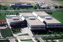
The Colorado Department of Corrections has its headquarters in an unincorporated area in the county.[13][14]
Elected Officials[]
| Position | Elected Official |
|---|---|
| County Commissioner District 1 | Holly Williams |
| County Commissioner District 2 | Carrie Geitner |
| County Commissioner District 3 | Stan VanderWerf |
| County Commissioner District 4 | Longinos Gonzalez Jr. |
| County Commissioner District 5 | Cami Bremer |
| County Assessor | Steve Schleiker |
| County Clerk and Recorder | Chuck Broerman |
| County Coroner | Dr. Leon Kelly |
| District Attorney | Michael Allen |
| County Sherriff | Sheriff Bill Elder |
| County Surveyor | Richard Mariotti |
| County Treasurer | Mark Lowderman |
Top employers[]
According to the city's 2014 Comprehensive Annual Financial Report,[15] the top employers in the city are:
| # | Employer | % of County Employment (increase/decrease/flat) |
|---|---|---|
| 1 | Fort Carson | 10.38% (+) |
| 2 | Peterson Air Force Base | 3.89% (−) |
| 3 | Schriever Air Force Base | 2.50% (−) |
| 4 | United States Air Force Academy | 2.48% (−) |
| 5 | Colorado Springs School District 11 | 1.30% (−) |
| 6 | Academy School District 20 | 1.05% (+) |
| 7 | Memorial Health Services | 1.03% (−) |
| 8 | 0.93% (=) | |
| 9 | City of Colorado Springs | 0.75% (−) |
| 10 | El Paso County | 0.69% (−) |
Libraries[]
The Pikes Peak Library District provides library services through its 15 branches and bookmobiles to the residents of El Paso County, with the exception of Widefield School District 3. The mission of the District is "Providing resources and opportunities that impact individual lives and build community. Seek. Engage. Transform."[16]
Politics[]
El Paso is somewhat conservative for a large urban county. It is by far the most populous reliably Republican county in Colorado. The county's Republican tilt predates the evangelical Christian influence in the area. It has voted Republican in every presidential election since 1920, except for the Democratic landslides of 1936 and 1964. In 2020, Joe Biden became the first Democrat to garner 40 percent of the county's vote since Lyndon Johnson's landslide of 1964, and only the third to do so since Franklin D. Roosevelt.
Dick Lamm in 1982 remains the last Democrat to win the county in a gubernatorial election. Eight years later, the county was one of only four in the state to back governor Roy Romer's opponent John Andrews.[17][18] The last Democrat to win the county in a Senate election was Gary Hart in 1974.[19]
Military installations[]
This section needs additional citations for verification. (June 2014) |
El Paso County is home to Army, Air Force and Space Force bases. These military installations border the city, to the north, south, and east, aside from Schriever Space Force Base, which is located about 10 miles east of Peterson Air Force Base.[21][circular reference]
Fort Carson[]
Fort Carson, "The Mountain Post", is located just south of Colorado Springs at the base of the Rocky Mountains. It was established in 1942, following Japan's attack on Pearl Harbor. The city of Colorado Springs purchased land south of the city and donated it to the War Department. Construction began immediately and the first building, the camp headquarters, was completed January 31, 1942. Camp Carson was named in honor of the legendary Army scout, Gen. Christopher "Kit" Carson, who explored much of the West in the 1800s. Camp Carson became Fort Carson in 1954. An additional training area was purchased in September 1983 and is called Piñon Canyon Maneuver Site (PCMS).
Currently, Fort Carson is the home of 4th Infantry Division and several other units, including 10th Special Forces Group (Airborne), the Colorado National Guard Regional Training Institute and PCMS, which is a maneuver training site for Fort Carson located near Trinidad, Colorado. The installation totals about 137,000 acres and PCMS is roughly 236,000 acres. Fort Carson has around 3,000 family housing units and 66 soldier barracks with 8,132 rooms. Services on the installation include four elementary schools, one middle school, a commissary, an exchange, and Evans Army Community Hospital, as well as Army Community Service facilities to include child development centers and youth centers and family morale, welfare, and recreation facilities to include a bowling alley, golf course, and numerous parks.
Fort Carson's economic impact on Colorado Springs and the surrounding communities was approximately $2.3 billion during fiscal year 2014. Fort Carson has about 24,300 soldiers on the installation, with 44,700 family members. The installation also has around 8,000 veterans and 3,300 civilians.[22]
Peterson Air Force Base[]
The Air Force has critical aspects of their service based at Colorado Springs, which carry on missile defense operations and development. The Air Force bases a large section of its national missile defense operations here, with Peterson Air Force Base set to operate large sections of the program. Peterson AFB is currently the headquarters of the operations-half of Army Space and Missile Defense Command/Army Strategic Command.[citation needed]
Peterson is also headquarters for the United States Northern Command, one of the Unified Combatant Commands, which directs all branches of the U.S. military operations in their area of responsibility, which includes the continental United States, Alaska, Canada, and Mexico. In the event of national emergencies, the President or Secretary of Defense can call upon the command for any required military assistance. Service members from every branch of the US military are stationed at the command.[citation needed]
Schriever Space Force Base (formerly Schriever AFB and Falcon AFB)[]
Schriever Space Force Base is home to the 50th Space Wing, responsible for the operation and support of 175 Department of Defense satellites and installation support to 16 major tenant units, with a workforce of more than 7,700 personnel.[23] It is the location of the Global Positioning System (GPS) master control station and GPS Operations Center[24] and the US Naval Observatory Alternate Master Clock,[25] used to synchronize GPS satellite time. Schriever is also developing parts of national missile defense and runs parts of the annual wargames used by the nation's military.[citation needed] The base indirectly contributes an estimated $1 billion to the local Colorado Springs, CO area annually.[26]
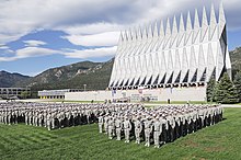
United States Air Force Academy[]
Bordering the northwestern side of the city are the grounds of the United States Air Force Academy, where cadets train to become officers in the Air Force. The campus is famous for its unique chapel, and draws visitors year round. Most of the Air Force Academy's sports programs participate in the Mountain West Conference.[27]
NORAD and Cheyenne Mountain Air Station[]
The North American Aerospace Defense Command (NORAD), a component of America's missile defense system, is located in Cheyenne Mountain Air Station. When it was built at the height of the Cold War, NORAD caused some anxiety for the residents in and around Colorado Springs, who believed the installation would be a primary target during a nuclear attack. Although NORAD still operates today, it is primarily given the task of the tracking of ICBMs, and the military has recently decided to place Cheyenne Mountain's NORAD/NORTHCOM operations on warm standby and move operations to nearby Peterson Air Force Base.[28]
See also[]
- Outline of Colorado
- Index of Colorado-related articles
- El Paso County, Jefferson Territory
- Colorado census statistical areas
- Front Range Urban Corridor
- National Register of Historic Places listings in El Paso County, Colorado
Notes[]
- ^ The leading "other" candidate, Progressive Theodore Roosevelt, received 5,332 votes, while Socialist candidate Eugene Debs received 928 votes, Prohibition candidate Eugene Chafin received 394 votes, and Socialist Labor candidate Arthur Reimer received 17 votes.
References[]
- ^ Jump up to: a b "State & County QuickFacts". United States Census Bureau. Archived from the original on April 20, 2020. Retrieved April 20, 2020.
- ^ "Find a County". National Association of Counties. Archived from the original on July 4, 2012. Retrieved June 7, 2011.
- ^ Breathes, William (November 23, 2012). "Marijuana: Amendment 64 passes in El Paso County by fewer than a dozen votes". westword.com. Retrieved March 16, 2018.
- ^ Gazette, Rachel Riley, The. "El Paso County declared '2nd Amendment preservation county' as legislature weighs red flag gun bill". Colorado Politics. Retrieved January 18, 2020.
- ^ "An Act to provide a temporary Government for the Territory of Colorado" (PDF). Thirty-sixth United States Congress. February 28, 1861. Retrieved November 26, 2007.
- ^ "US Gazetteer files: 2010, 2000, and 1990". United States Census Bureau. February 12, 2011. Retrieved April 23, 2011.
- ^ "U.S. Decennial Census". United States Census Bureau. Retrieved June 7, 2014.
- ^ "Historical Census Browser". University of Virginia Library. Retrieved June 7, 2014.
- ^ "Population of Counties by Decennial Census: 1900 to 1990". United States Census Bureau. Retrieved June 7, 2014.
- ^ "Census 2000 PHC-T-4. Ranking Tables for Counties: 1990 and 2000" (PDF). United States Census Bureau. Retrieved June 7, 2014.
- ^ "U.S. Census website". United States Census Bureau. Retrieved May 14, 2011.
- ^ https://commons.wikimedia.org/wiki/File:El_Paso_County_Colorado_Population_Pyramid.png
- ^ "Contacts[permanent dead link]." Colorado Department of Corrections. Retrieved on December 7, 2009.
- ^ "Council District Map." City of Colorado Springs. Retrieved on December 7, 2009.
- ^ "City of Colorado Springs CAFR" (PDF). Retrieved March 28, 2016.
- ^ "About PPLD | PPLD.org". ppld.org. Retrieved November 20, 2019.
- ^ Leip, David. "Dave Leip's Atlas of U.S. Presidential Elections". uselectionatlas.org. Retrieved September 27, 2020.
- ^ Leip, David. "Dave Leip's Atlas of U.S. Presidential Elections". uselectionatlas.org. Retrieved September 27, 2020.
- ^ Leip, David. "Dave Leip's Atlas of U.S. Presidential Elections". uselectionatlas.org. Retrieved September 27, 2020.
- ^ Leip, David. "Dave Leip's Atlas of U.S. Presidential Elections". uselectionatlas.org. Retrieved May 26, 2017.
- ^ Schriever Air Force Base
- ^ "Fort Carson". Fort Carson. Retrieved February 23, 2016.
- ^ "Schriever Air Force Base 50th Space Wing". Schriever Air Force Base. Archived from the original on October 21, 2013. Retrieved February 16, 2016.
- ^ "GPS Operations Center". Air Force Space Command. Archived from the original on August 23, 2006. Retrieved September 15, 2010.
- ^ Staff Sgt. Don Branum (June 15, 2006). "23:59:60...Atomic clock takes quantum leap". Air Force Space Command. Archived from the original on September 30, 2011. Retrieved September 15, 2010.
- ^ "Schriever Air Force Base". Schriever Air Force Base. Archived from the original on March 3, 2016. Retrieved February 16, 2016.
- ^ themwc.com
- ^ Finley, Bruce (July 27, 2006). "Military to put Cheyenne Mountain on standby – The Denver Post". The Denver Post. Retrieved October 5, 2009.
External links[]
- El Paso County Government website
- Colorado County Evolution by Don Stanwyck
- Colorado Historical Society
| show Places adjacent to El Paso County, Colorado |
|---|
| show Municipalities and communities of El Paso County, Colorado, United States |
|---|


| show Authority control |
|---|
- Colorado counties
- El Paso County, Colorado
- 1861 establishments in Colorado Territory
- Eastern Plains
- Populated places established in 1861