Manitou Incline
| Manitou Incline | |
|---|---|
 View from the Barr Trail Bailout, approximately two-thirds up the incline | |
| Length | Approx. 0.88 miles (1.42 km) |
| Location | Manitou Springs, Colorado |
| Trailheads | Barr Trail |
| Use | Hiking |
| Elevation | |
| Highest point | Peak, 8,590 feet (2,620 m) |
| Lowest point | Base, 6,500 feet (2,000 m) |
| Hiking details | |
| Trail difficulty | Extreme |
| Season | Year round |
| Sights | Pikes Peak |
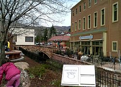
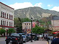
| Manitou Springs, Colorado |
|---|
 |
The Manitou Springs Incline, also known as the Manitou Incline or simply the Incline, is a popular hiking trail rising above Manitou Springs, Colorado, near Colorado Springs. The Incline ascends on the east slope of Rocky Mountain which is itself on the eastern flank of Pikes Peak. The trail is the remains of a former 3 ft (914 mm) narrow gauge[1] funicular railway whose tracks washed out during a rock slide in 1990. The Incline is famous for its sweeping views and steep grade, with an average grade of 45% (24°) and as steep as 68% (34°) in places,[2] making it a fitness challenge for locals of the Colorado Springs area. The incline gains 2,011 feet (613 m) of elevation in 0.88 miles (1.42 km) horizontal. Currently the Incline has approximately 2,744 steps[3] from the bottom to the summit, although the top step is numbered "2768". The number of steps changes occasionally with trail maintenance and deterioration.
Reservations are still currently required to hike the Manitou Incline which can be made at the Manitou Incline page on the City of Colorado Springs website.

History[]

The Incline was constructed under the ownership of Dr. Newton N. Brumback (1854-1923)[4] as a funicular in 1907, for the purpose of providing access to water tanks at the top of the mountain that would provide gravity-fed water pressure to the cities of Manitou Springs and Colorado Springs.[5] Originally, the railroad was constructed to access a hydroelectric plant and service the water pipes. Shortly after its construction, the Manitou and Pike's Peak Railway was opened as a tourist attraction.
The Incline's original summit house was a rudimentary building constructed from left-over materials from the Incline's construction. It burned down in 1914. The summit house was quickly rebuilt into a more elaborate, comfortable, and safer structure, offering shelter from storms and the elements. The 1914 structure remained until 1958 when it was replaced by an updated summit house, which remained until it was dismantled after the Incline's closure. The Incline operated under the Pikes Peak Cog Railway until a rock slide in 1990 washed out the rail bed and the Cog Railway decided to not repair the tracks.
During the COVID-19 pandemic, the Manitou Springs City Council, under emergency declaration, voted to close the Incline on March 17th, 2020. The closure was a result of health concerns over a lack of social distancing and other health measures, as well as a way to mitigate the number of incidents on the Incline that the fire department would have to address. Manitou Springs stated in a press release on March 18th, 2020, "the first responders who address emergencies on the Incline are put into a high risk situation." The Mayor of Manitou Springs, John Graham, stated: "While we were reluctant to close the Incline, we had far more grave reservations regarding public health."[6] On August 4, 2020, the Manitou Springs City Council approved a memorandum of understanding (MOU) between Colorado Springs and Manitou Springs to reopen the Incline. Within this MOU was protocol for a free online reservation system that managedthe number of users, with all reservations being handled by the City of Colorado Springs.[7]
Legal battles[]
Though the Incline is a popular hike and fitness destination for locals, its existence since its public closing in 1990 has been controversial. Many locals and some National Forest Service officials wanted to keep it closed to allow it to revegetate, either by reseeding or allowing nature to reclaim the scar.[8]
Another controversy centered on parking rights at the base of the trail head, which is co-located with the Barr Trail trailhead and the Pikes Peak Cog Railway. All three sit in the narrow Ruxton Canyon, and the popularity of the Incline has caused major parking conflicts with these entities.[2][9] The land through which the Incline passes on its ascent is owned by three entities: the bottom portion is owned by the City of Colorado Springs, the middle section is owned by the Pikes Peak Cog Railway, and the top portion is owned by the US Forest Service.[10] The controversial land swap known as "Strawberry Fields" between Colorado Springs and the Broadmoor traded 14 sections of land totalling 371 acres for 189.5 acres of Colorado Springs land. The part of the Incline of owned by the Cog Railway was included in this land swap making all of the Incline now publicly owned land. The Strawberry Fields land swap was approved but was challenged in court by a citizens group.[11]
The legal battles over the conversion of the Incline to a public hiking trail were finally resolved in January 2013, after the issue was settled by the United States Congress.[12]
Hiking trail and fitness challenge[]
Since its closure as a railway in 1990, the trail has steadily grown in popularity as a hiking trail and fitness challenge.[9] The base of the Incline sits at 6,600 feet (2,000 m) and the trail climbs 2,011 feet (613 m) in about 0.88 miles (1.42 km). Hiking the trail should not be undertaken by the physically unfit, as there is no vehicle access to the trail and anyone injured or suffering a medical emergency will have to walk or be carried down by other hikers. At the top of the Incline, there is a tie-in to the Barr Trail that allows for hikers to descend without going back down the Incline. (This descent is approximately 2.79 miles or 4.49 kilometres, with a much gentler slope.) Due to the close proximity to the large and active population center of Colorado Springs, the large military population of nearby Army and Air Force bases, and the US Olympic Training Center, the Incline has become a popular fitness destination for those seeking an intense workout.[13][14][15]

About 2⁄3 of the way up, a Barr Trail switchback passes just a few yards from the Incline, and there is a pathway that allows those who wish to exit the Incline the opportunity to take the Barr Trail back down as a 'bailout'. In 2020 two new bailouts were added that exit to the right (north) and lead to the Ute Pass trail. The first, the Lower Ute connector, is at step #395 and the second, the Upper Ute connector, is at step #1300 which is about 500 steps below the Barr trail bailout. These two new bailouts give hikers the option to exit a very difficult trail and also serve the purpose of alleviating some of the heavy traffic on the lower Barr Trail. The Incline is at its steepest grade just after the Barr Trail bailout for about another 200 feet (61 m), when it reaches the 'false summit', a semi-crest in the trail that obscures the true summit to hikers due to its extreme grade. Those who reach the false summit are about 3⁄4 of the way to the top, but still have several hundred feet to climb.
Records[]
The verifiable satellite-tracked record was set September 25, 2015, of 17:45 by US mountain running team member Joseph Gray. Also notable is the time of twelve-time champion of the Pikes Peak Marathon Matt Carpenter (18:31).[16] The female Incline record is attributed to Allie McLaughlin of Colorado Springs (20:07).[17]
In 2012, local resident Ed Baxter, 58, became the first person to complete the "Inclinathon", 13 consecutive trips up and down the Incline in one day. Baxter completed the effort in just over 13 hours.[18] In 2012, Brandon Stapanowich broke the speed record for an Inclinathon at 11 hours 46 minutes.[19] In 2014, Stapanowich also completed the first ever Ultra-Inclinathon, completing 22 laps of the Incline in 24 hours, the most ever completed in a day. He gained 44,000 feet (13,000 m) of altitude in this endeavor.[20] On May 16, 2015, Wade Gardner broke the speed record for the Inclinathon with a time of 10 hours, 34 mins.
In 2011, Greg Cummings (a local resident with Type-I Diabetes) became the first person to hike the Incline more than 500 times in one year. Cummings hiked the Incline 601 times and ascended Pikes Peak 34 times, setting the World Record for elevation climbed in one year at just under 1.4 million vertical feet (430,000 metres).[21] In 2013, Roger Austin ascended the Incline 719 times and reset the World Record to roughly 1.45 million vertical feet (440,000 metres) hiked/climbed in one year.[22] In 2014, Greg Cummings ascended the Incline 1,400 times in 330 consecutive days, before the Incline closed for repairs. Along with other ascents, Cummings reset the World Record to 2.9 million vertical feet (880,000 metres) climbed in a year.[23] In 2015, Roger Austin ascended the Incline 1,719 times and again reset the World Record to 3.4 million vertical feet (1,000,000 metres). Along the way, Austin set the record for most Inclinathons in one year at 26. On January 11, 2020, at the age of 62, Greg Cummings retook the one year Incline ascent record by completing 1,825 ascents in the previous 365 days and reset the World Record to 3.6 million vertical feet (1,100,000 metres) climbed in one year.[citation needed]
Images[]

Incline boxcar 1908
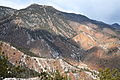
View of the Incline from the Red Mountain Trail
The Incline rising above Manitou Springs

View of the Manitou Incline from the base, May 2013

The Incline viewed from about 1/4 up from the trail head

Nighttime panorama of Colorado Springs as viewed from the Incline.


References[]
- ^ "Trams of the World 2017" (PDF). Blickpunkt Straßenbahn. January 24, 2017. Archived from the original (PDF) on February 16, 2017. Retrieved February 16, 2017.
- ^ Jump up to: a b "Fight over Cog an uphill battle". theGazette.com. Retrieved February 15, 2013.
- ^ "The Manitou Springs Incline". Visit Colorado Springs. Retrieved May 1, 2019.
- ^ "Dr. Newton N. Brumbach 1854-1923". findagrave.com. Retrieved February 19, 2013.
- ^ History of Shenandoah County, Virginia. Genealogical.com. 1980. ISBN 9780806380117. Retrieved February 19, 2013.
- ^ "News/Press Releases | Manitou Springs, CO". www.manitouspringsgov.com. Retrieved May 7, 2020.
- ^ Trefry, Alex (August 5, 2020). "Manitou Springs City Council Approves MOU Regarding a Free Incline Reservation System".
- ^ "Manitou rail scar". theGazette.com. Retrieved February 15, 2013.
- ^ Jump up to: a b "Signs point to Incline deal". theGazette.com. Retrieved February 15, 2013.
- ^ "Mt. Manitou scenic Incline (Railway)". InclineClub. Retrieved February 15, 2013.
- ^ "Strawberry Fields in Cheyenne Cañon is on the table for a swap with The Broadmoor". Colorado Springs Independent. Retrieved February 10, 2016.
- ^ "Manitou Incline bill signed into law". The Colorado Springs Independent. Retrieved February 15, 2013.
- ^ "Opening the Manitou Incline, How we Got There". OutthereColorado.com. Retrieved February 15, 2013.
- ^ "Olympic Training Towns: Colorado Springs". Sports Illustrated. Retrieved February 15, 2013.
- ^ "Up a Mountain, Olympic Dreams are Carved". New York Times. Retrieved February 15, 2013.
- ^ "A pro shares easy-to-follow steps for your best Incline time". OutThereColorado.com. Archived from the original on April 11, 2013. Retrieved February 15, 2013.
- ^ Bergsten, Tim. "Fastest woman on the Incline". Colorado Springs Independent. Retrieved September 10, 2015.
- ^ "Ed Baxter climbs Manitou Incline 13 times in 13 hours, 15 minutes". PikesPeakSports.us. Retrieved February 15, 2013.
- ^ "Inclinathon champ Brandon Stapanowich complete's 13 laps on Manitou Incline in 11 hours, 47 minutes!". pikespeaksports.us. Retrieved May 5, 2014.
- ^ "Brandon Stapanowich nails 22 Incline ascents in 24 Hour UltraInclinathon". pikespeaksports.us. Retrieved July 5, 2014.
- ^ Rappold, Scott (October 22, 2011). "Springs man 'hikes' to the International Space Station". The Gazette. Archived from the original on April 24, 2013. Retrieved June 26, 2013.
- ^ "Q&A with Roger Austin, the man who knocked out 371 trips up the incline in 2012". PikesPeakSports.us. Retrieved February 15, 2013.
- ^ "Colorado Springs man sets Manitou Incline record despite suffering from diabetes". The Gazette. Retrieved January 17, 2015.
External links[]
- Manitou Incline Website with trail description and history
- Facebook page
- "Inclined", documentary by Dean Leslie, 2019
Coordinates: 38°51′25″N 104°55′55″W / 38.856845°N 104.931956°W

- Rail trails in Colorado
- Manitou Springs, Colorado
- 3 ft gauge railways in the United States