List of federal lands in Colorado

This is a list of federal lands in the U.S. State of Colorado. The United States federal government owns 36.23% of Colorado's total land area.
National Park System[]
The National Park System includes 21 areas in Colorado. The National Park Service manages 17 of these 21 areas.
National Parks[]

The four National Parks within Colorado are:
- Black Canyon of the Gunnison National Park
- Great Sand Dunes National Park and Preserve
- Mesa Verde National Park and UNESCO World Heritage Site
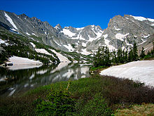
- Rocky Mountain National Park
National Monuments[]
The eight National Monuments in Colorado are:
- Browns Canyon National Monument[a]
- Canyons of the Ancients National Monument[b]
- Chimney Rock National Monument[c]
- Colorado National Monument
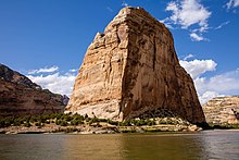
- Dinosaur National Monument[d]
- Florissant Fossil Beds National Monument
- Hovenweep National Monument[e]
- Yucca House National Monument
National Historic Sites[]

The two National Historic Sites within Colorado are:
- Bent's Old Fort National Historic Site
- Sand Creek Massacre National Historic Site
National Recreation Areas[]

The two National Recreation Areas within Colorado are::
- Arapaho National Recreation Area[c]
- Curecanti National Recreation Area
National Historic Trails[]

The four National Historic Trails that pass through Colorado are:
- California National Historic Trail[f] through Sedgwick County
- Old Spanish National Historic Trail[g] through southwestern Colorado
- Pony Express National Historic Trail[h] through Sedgwick County
- Santa Fe National Historic Trail[i] through southeastern Colorado
National Scenic Trail[]

The National Scenic Trail that passes through Colorado is:
- Continental Divide National Scenic Trail[j] along the Continental Divide of the Americas
National Forests[]


The United States Forest Service manages the 11 National Forests within Colorado.
- Arapaho National Forest
- Grand Mesa National Forest
- Gunnison National Forest
- Pike National Forest
- Rio Grande National Forest
- Roosevelt National Forest
- Routt National Forest
- San Isabel National Forest
- San Juan National Forest
- Uncompahgre National Forest
- White River National Forest
National Grasslands[]

The United States Forest Service manages the two National Grasslands within Colorado.
- Comanche National Grassland
- Pawnee National Grassland
National Wildernesses[]


There are 44 National Wildernesses within Colorado. The United States Forest Service manages 34, the National Park Service manages four, the Bureau of Land Management manages three, the United States Forest Service and the Bureau of Land Management jointly manage two, and the United States Forest Service and the National Park Service jointly manage one National Wilderness.
- Black Canyon of the Gunnison Wilderness[k]
- Black Ridge Canyons Wilderness[b]
- Buffalo Peaks Wilderness[c]
- Byers Peak Wilderness[c]
- Cache La Poudre Wilderness[c]
- Collegiate Peaks Wilderness[c]
- Comanche Peak Wilderness[c]
- Dominguez Canyon Wilderness[b]
- Eagles Nest Wilderness[c]
- Flat Tops Wilderness[c]
- Fossil Ridge Wilderness[c]
- Great Sand Dunes Wilderness[k]
- Greenhorn Mountain Wilderness[c]
- Gunnison Gorge Wilderness[c]
- Hermosa Creek Wilderness[c]
- Holy Cross Wilderness[c]
- Hunter-Fryingpan Wilderness[c]
- Indian Peaks Wilderness[l]
- James Peak Wilderness[c]
- La Garita Wilderness[c]
- Lizard Head Wilderness[c]
- Lost Creek Wilderness[c]
- Maroon Bells-Snowmass Wilderness[c]
- Mesa Verde Wilderness[k]
- Mount Evans Wilderness[c]
- Mount Massive Wilderness[c]
- Mount Sneffels Wilderness[c]
- Mount Zirkel Wilderness[c]
- Neota Wilderness[c]
- Never Summer Wilderness[c]
- Platte River Wilderness[c]
- Powderhorn Wilderness[a]
- Ptarmigan Peak Wilderness[c]
- Raggeds Wilderness[c]
- Rawah Wilderness[c]
- Rocky Mountain National Park Wilderness[k]
- Sangre de Cristo Wilderness[c]
- Sarvis Creek Wilderness[c]
- South San Juan Wilderness[c]
- Spanish Peaks Wilderness[c]
- Uncompahgre Wilderness[a]
- Vasquez Peak Wilderness[c]
- Weminuche Wilderness[c]
- West Elk Wilderness[c]
National Conservation Areas[]

The Bureau of Land Management manages the three National Conservation Areas within Colorado.
- Dominguez–Escalante National Conservation Area
- Gunnison Gorge National Conservation Area
- McInnis Canyons National Conservation Area
National Wildlife Refuges[]

The United States Fish and Wildlife Service manages the eight National Wildlife Refuges within Colorado.
- Alamosa National Wildlife Refuge
- Arapaho National Wildlife Refuge
- Baca National Wildlife Refuge
- Browns Park National Wildlife Refuge
- Monte Vista National Wildlife Refuge
- Rocky Flats National Wildlife Refuge
- Rocky Mountain Arsenal National Wildlife Refuge
- Two Ponds National Wildlife Refuge
Military installations[]

The major military installations in Colorado include:
- Buckley Space Force Base
- Air Reserve Personnel Center
- Fort Carson (U.S. Army)
- Peterson Space Force Base
- Pueblo Chemical Depot (U.S. Army)
- Schriever Space Force Base
- United States Air Force Academy
Native American reservations[]
The two Native American reservations remaining in Colorado are:
- Southern Ute Indian Reservation — Southern Ute Indian Tribe (1873)
- Ute Mountain Ute Indian Reservation — Ute Mountain Ute Tribe (1940)
Other federal lands[]
The Bureau of Land Management manages the extensive federal land holdings in western Colorado not managed by another federal agency.
Areas of Critical Environmental Concern[]

The Bureau of Land Management has designated 88 Areas of Critical Environmental Concern in western Colorado.
See also[]
- Colorado
- Bibliography of Colorado
- Index of Colorado-related articles
- Outline of Colorado
- Colorado statistical areas
- Geography of Colorado
- History of Colorado
- List of counties in Colorado
- List of places in Colorado
- List of protected areas of Colorado
Notes[]
- ^ Jump up to: a b c Jointly managed by the United States Department of the Interior, Bureau of Land Management and the United States Department of Agriculture, United States Forest Service.
- ^ Jump up to: a b c Managed by the United States Department of the Interior, Bureau of Land Management.
- ^ Jump up to: a b c d e f g h i j k l m n o p q r s t u v w x y z aa ab ac ad ae af ag ah ai aj ak Managed by the United States Department of Agriculture, United States Forest Service.
- ^ Dinosaur National Monument extends into the State of Utah.
- ^ Hovenweep National Monument extends into the State of Utah.
- ^ The California National Historic Trail traverses ten U.S. states: Missouri, Kansas, Nebraska, Colorado, Wyoming, Idaho, Utah, Nevada, Oregon, and California.
- ^ The Old Spanish National Historic Trail traverses six U.S. states: New Mexico, Colorado, Utah, Arizona, Nevada, and California.
- ^ The Pony Express National Historic Trail traverses eight U.S. states: Missouri, Kansas, Nebraska, Colorado, Wyoming, Utah, Nevada, and California.
- ^ The Santa Fe National Historic Trail traverses five U.S. states: Missouri, Kansas, Colorado, Oklahoma, and New Mexico.
- ^ The Continental Divide National Scenic Trail traverses five U.S. states: Montana, Idaho, Wyoming, Colorado, and New Mexico.
- ^ Jump up to: a b c d Managed by the United States Department of the Interior, National Park Service.
- ^ Jointly managed by the United States Department of the Interior, National Park Service and the United States Department of Agriculture, National Forest Service.
External links[]
 Definitions from Wiktionary
 Media from Wikimedia Commons
 News from Wikinews
 Quotations from Wikiquote
 Texts from Wikisource
 Textbooks from Wikibooks
 Resources from Wikiversity
- United States federal government website
- Southern Ute Indian Tribe website
- Ute Mountain Ute Tribe website

Coordinates: 38°59′50″N 105°32′52″W / 38.9972°N 105.5478°W

- Colorado geography-related lists
- Colorado history-related lists
- Protected areas of Colorado
- Tourist attractions in Colorado