Colorado State Highway 149
 | ||||
|---|---|---|---|---|
 Map of southwestern Colorado with SH 149 highlighted in red | ||||
| Route information | ||||
| Maintained by CDOT | ||||
| Length | 117.522 mi[1] (189.133 km) | |||
| Major junctions | ||||
| South end | ||||
| North end | ||||
| Location | ||||
| Counties | Rio Grande, Mineral, Hinsdale, Gunnison | |||
| Highway system | ||||
Colorado State Highways
| ||||
State Highway 149 (SH 149) is a 117.522-mile-long (189.133 km) state highway in southwestern Colorado, United States. SH 149's southern terminus is at U.S. Highway 160 (US 160) in South Fork, and the northern terminus is at US 50 west of Gunnison.
Route description[]
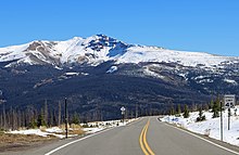
SH 149 begins in the south at its junction with US 160 at South Fork. From there the road winds its way generally northward through the San Juan Mountains. The first portion of the road parallels the upper Rio Grande as it passes through Rio Grande National Forest. SH 149 winds through the mountains for 21 miles (34 km) before coming to the historic mining town of Creede. From there the road continues its climb into the mountains and eventually turns away from the Rio Grande to cross the Continental Divide at Spring Creek Pass at an elevation of 10,901 ft (3,323 m). At this point the road passes into Gunnison National Forest and, after a brief descent, begins an even higher climb to Slumgullion Pass elevated 11,361 ft (3,463 m). From there, the highway descends and crosses the Slumgullion Earthflow before it drops to the town of Lake City, where it begins to parallel Lake Fork, a tributary of the Gunnison River. SH 149 follows Lake Fork down out of the mountains and eventually turns away to the east passing just north of Powderhorn where the road again turns northward. After skirting the southern edge of Curecanti National Recreation Area, the highway crosses the Gunnison River and finally reaches its northern terminus at US 50 approximately nine miles west of Gunnison. There are no major junctions along its entire length.[1]
History[]
The route was established in the 1920s and was completely paved by 1977.[2]
Major intersections[]
| County | Location | mi[1] | km | Destinations | Notes | |||
|---|---|---|---|---|---|---|---|---|
| Rio Grande | | 0.000 | 0.000 | South end of route | ||||
| Mineral |
No major junctions | |||||||
| Hinsdale |
No major junctions | |||||||
| Gunnison | | 117.522 | 189.133 | North end of route | ||||
| 1.000 mi = 1.609 km; 1.000 km = 0.621 mi | ||||||||
References[]
- ^ a b c "Segment Descriptions for Highway 149". Colorado Department of Transportation. Retrieved 2008-03-27.[permanent dead link]
- ^ Salek, Matthew E. "Colorado Routes 140-159". Retrieved 2010-04-08.
External links[]
| ( • help)
|
- State highways in Colorado
- Transportation in Rio Grande County, Colorado
- Transportation in Hinsdale County, Colorado
- Transportation in Gunnison County, Colorado
