Cotorro
Cotorro | |
|---|---|
Municipality of Havana | |
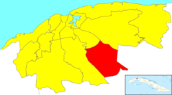 Location of Cotorro in Havana | |
| Coordinates: 23°01′34″N 82°14′51″W / 23.02611°N 82.24750°WCoordinates: 23°01′34″N 82°14′51″W / 23.02611°N 82.24750°W | |
| Country | |
| Province | |
| Wards (Consejos Populares) | , , , , , |
| Area | |
| • Total | 66 km2 (25 sq mi) |
| Population (2004)[2] | |
| • Total | 74,650 |
| • Density | 1,131/km2 (2,930/sq mi) |
| Time zone | UTC-5 (EST) |
| Area code(s) | +53-7 |

Cotorro, or San Pedro del Cotorro, is one of the 15 municipalities (municipios in Spanish) in the city of Havana, Cuba.
Overview[]
The municipality is situated by the Carretera Central (Central Highway), and main autopista (motorway). Cotorro is 16 km from Old Havana. Its foundation dates to 1822. By the end of the 1950s, Cotorro had grown in such a way that it was exceeding in extension and population to the head of the municipality.
Twin towns – sister cities[]
 Campinas, Brazil
References[]
- ^ Statoids (July 2003). "Municipios of Cuba". Retrieved 2007-10-06.
- ^ Atenas.cu (2004). "2004 Population trends, by Province and Municipality" (in Spanish). Archived from the original on 2006-07-14. Retrieved 2007-10-06.
External links[]
 Media related to Cotorro at Wikimedia Commons
- Cotorro website
- Cotorro cultural website
| show Places adjacent to Cotorro |
|---|
| Authority control |
|
|---|
This Cuban location article is a stub. You can help Wikipedia by . |
Categories:
- Municipalities of Havana
- Cuba geography stubs