Cottonton, Alabama
Cottonton
, Alabama | |
|---|---|
 Cottonton
, Alabama | |
| Coordinates: 32°08′49″N 85°04′26″W / 32.14694°N 85.07389°WCoordinates: 32°08′49″N 85°04′26″W / 32.14694°N 85.07389°W | |
| Country | United States |
| State | Alabama |
| County | Russell |
| Elevation | 220 ft (70 m) |
| Population | 136 |
| Time zone | UTC-6 (Central (CST)) |
| • Summer (DST) | UTC-5 (CDT) |
| ZIP code | 36851 |
| Area code(s) | 334 |
| GNIS feature ID | 116693[1] |


Cottonton is an unincorporated community in Russell County, Alabama, United States.
Geography[]
Cottonton is located in southeastern Russell County along the Chattahoochee River, which is also the Georgia state line, at 32° 8′ 49″ N, 85° 4′ 26″ W (32.146944, -85.073889).[2] Alabama State Routes 165 and 208 meet in the community. AL-165 leads north 26 mi (42 km) to Phenix City, the Russell County seat, and south 21 mi (34 km) to Eufaula (via a connection with U.S. Route 431). AL-208 serves as a connector route to Georgia State Route 39 Spur across the Chattahoochee River, and is only about 2 mi (3.2 km) long.
Notable person[]
- J. C. Hartman, former Major League Baseball player
Climate[]
The climate in this area is characterized by hot, humid summers and generally mild to cool winters. According to the Köppen Climate Classification system, Cottonton has a humid subtropical climate, abbreviated "Cfa" on climate maps. [3]
Post office[]
Cottonton has a post office with ZIP code 36851.[4]
Gallery[]
Below are photographs taken in Cottonton as part of the Historic American Buildings Survey:
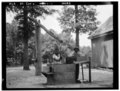
Well sweep, Cliatt Plantation

Old mule gin house, Cliatt Plantation


References[]
- ^ "Cottonton". Geographic Names Information System. United States Geological Survey.
- ^ "GeoHack - Cottonton, Alabama".
- ^ Climate Summary for Cottonton, Alabama
- ^ United States Postal Service (2012). "USPS - Look Up a ZIP Code". Retrieved 2012-02-15.
Municipalities and communities of Russell County, Alabama, United States | ||
|---|---|---|
| City |  | |
| Town | ||
| CDP | ||
| Unincorporated communities | ||
| Former city | ||
| Footnotes | ‡This populated place also has portions in an adjacent county or counties | |
| ||
This Russell County, Alabama state location article is a stub. You can help Wikipedia by . |
- Unincorporated communities in Russell County, Alabama
- Unincorporated communities in Alabama
- South Alabama geography stubs