County of Auburn
| Auburn Queensland | |||||||||||||||
|---|---|---|---|---|---|---|---|---|---|---|---|---|---|---|---|
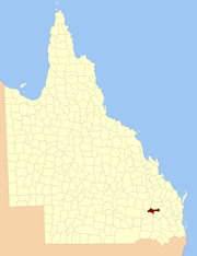
 Location within Queensland | |||||||||||||||
| |||||||||||||||

County of Auburn map, 2 miles to an inch, 1922
The County of Auburn is a county (a cadastral division) in the Darling Downs region of Queensland, Australia. Much of its area is within the . It was named and bounded by the Governor in Council on 7 March 1901 under the Land Act 1897.[1][2]
Parishes[]
Auburn is divided into parishes, as listed below:
| Parish | LGA | Coordinates |
|---|---|---|
| Athlone | Western Downs | 26°19′S 150°51′E / 26.317°S 150.850°E |
| Ballon | Western Downs | 26°25′S 150°51′E / 26.417°S 150.850°E |
| Bartsch | Western Downs | 26°30′S 150°07′E / 26.500°S 150.117°E |
| Bembil | Western Downs | 26°14′S 150°57′E / 26.233°S 150.950°E |
| Binkey | Western Downs | 26°21′S 150°11′E / 26.350°S 150.183°E |
| Burraburri | Western Downs | 26°25′S 151°06′E / 26.417°S 151.100°E |
| Delger | Western Downs | 26°19′S 151°03′E / 26.317°S 151.050°E |
| Hookswood | Western Downs | 26°29′S 150°21′E / 26.483°S 150.350°E |
| Macdonald | Western Downs | 26°21′S 150°40′E / 26.350°S 150.667°E |
| Malcolm | Western Downs | 26°20′S 150°29′E / 26.333°S 150.483°E |
| Pelham | Western Downs | 26°22′S 150°20′E / 26.367°S 150.333°E |
| Quandong | Western Downs | 26°14′S 150°18′E / 26.233°S 150.300°E |
| Wongongera | Western Downs | 26°32′S 150°31′E / 26.533°S 150.517°E |
References[]
- ^ "Auburn – county in Western Downs Region (entry 985)". Queensland Place Names. Queensland Government. Retrieved 28 November 2018.
- ^ Darling Downs District, County of Auburn Maps – D2 Series at Queensland Archives.
External links[]
Categories:
- Counties of Queensland
