County of Benambra
| Benambra Victoria | |||||||||||||||
|---|---|---|---|---|---|---|---|---|---|---|---|---|---|---|---|
 Location in Victoria | |||||||||||||||
| Established | 24 February 1871 | ||||||||||||||
| Area | 7,120 km2 (2,749.0 sq mi) | ||||||||||||||
| |||||||||||||||
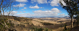
View of the land near Benambra
The County of Benambra is one of the 37 counties of Victoria which are part of the cadastral divisions of Australia, used for land titles. It is located between the Mitta Mitta River in the west, and the Murray River to the north and east. The town of Benambra is located near the southern edge. The area of the county roughly corresponds with the Electoral district of Benambra. Corryong is the largest town in the county. The county was proclaimed in 1871.
Parishes[]
Parishes include:
- Benambra, Victoria
- Berringa, Victoria
- Berringama, Victoria
- Bullioh, Victoria
- Corryong, Victoria
- Cudgewa, Victoria
- Granya, Victoria
- Koetong, Victoria
- Mitta Mitta, Victoria
- Tintaldra, Victoria
- Towong, Victoria
- Walwa, Victoria
References[]
- Vicnames, place name details
- Research aids, Victoria 1910
- Map of the counties of Benambra, Tambo, Croajingolong and Dargo in Victoria showing county boundaries, parish boundaries, main roads, telegraph lines and railways. 1886, J. Sands. National Library of Australia

Categories:
- Counties of Victoria (Australia)