Cours-la-Ville
Cours-la-Ville | |
|---|---|
Part of Cours | |
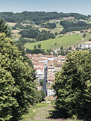 A general view of Cours-la-Ville | |
 Coat of arms | |
show Location of Cours-la-Ville | |
 Cours-la-Ville | |
| Coordinates: 46°06′01″N 4°19′17″E / 46.1003°N 4.3214°ECoordinates: 46°06′01″N 4°19′17″E / 46.1003°N 4.3214°E | |
| Country | France |
| Region | Auvergne-Rhône-Alpes |
| Department | Rhône |
| Arrondissement | Villefranche-sur-Saône |
| Canton | Thizy-les-Bourgs |
| Commune | Cours |
| Area 1 | 19.48 km2 (7.52 sq mi) |
| Population (2017)[1] | 3,674 |
| • Density | 190/km2 (490/sq mi) |
| Time zone | UTC+01:00 (CET) |
| • Summer (DST) | UTC+02:00 (CEST) |
| Postal code | 69470 |
| Elevation | 437–860 m (1,434–2,822 ft) (avg. 586 m or 1,923 ft) |
| 1 French Land Register data, which excludes lakes, ponds, glaciers > 1 km2 (0.386 sq mi or 247 acres) and river estuaries. | |


Cours-la-Ville is a former commune in the Rhône department in eastern France. It is the seat of the commune of Cours.
History[]
It was formed in 1974 by the merger of Cours and La Ville. On 1 January 2016, Cours-la-Ville, Pont-Trambouze and Thel merged becoming one commune called Cours.
International relations[]
Cours-la-Ville is twinned with:
See also[]
References[]
- ^ Téléchargement du fichier d'ensemble des populations légales en 2017, INSEE
- ^ "British towns twinned with French towns". Archant Community Media Ltd. Archived from the original on 2013-07-05. Retrieved 2013-07-11.
- ^ "Winslow Anglo French Twinning Association". Retrieved 23 April 2007.
| Wikimedia Commons has media related to Cours-la-Ville. |
| show Authority control |
|---|
This Rhône geographical article is a stub. You can help Wikipedia by . |
Categories:
- Former communes of Rhône (department)
- Beaujolais (province)
- Rhône (department) geography stubs