Cours, Rhône
Cours | |
|---|---|
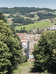 A general view of Cours-la-Ville | |
 Coat of arms | |
Location of Cours  | |
 Cours | |
| Coordinates: 46°06′01″N 4°19′17″E / 46.1003°N 4.3214°ECoordinates: 46°06′01″N 4°19′17″E / 46.1003°N 4.3214°E | |
| Country | France |
| Region | Auvergne-Rhône-Alpes |
| Department | Rhône |
| Arrondissement | Villefranche-sur-Saône |
| Canton | Thizy-les-Bourgs |
| Intercommunality | Communauté d'agglomération de l'Ouest Rhodanien |
| Government | |
| • Mayor (2020-2026) | Patrice Verchère |
| Area 1 | 33.81 km2 (13.05 sq mi) |
| Population (Jan. 2018)[1] | 4,379 |
| • Density | 130/km2 (340/sq mi) |
| Time zone | UTC+01:00 (CET) |
| • Summer (DST) | UTC+02:00 (CEST) |
| INSEE/Postal code | 69066 /69470 |
| Elevation | 407–905 m (1,335–2,969 ft) (avg. 656 m or 2,152 ft) |
| 1 French Land Register data, which excludes lakes, ponds, glaciers > 1 km2 (0.386 sq mi or 247 acres) and river estuaries. | |


Cours is a commune in the Rhône department and Auvergne-Rhône-Alpes region in eastern France. Cours-la-Ville is the municipal seat.
History[]
On 1 January 2016, Cours was created by the merger of Cours-la-Ville, Pont-Trambouze and Thel.[2]
References[]
- ^ "Populations légales 2018". The National Institute of Statistics and Economic Studies. 28 December 2020.
- ^ Arrêté du 18 novembre 2015 portant création de la commune nouvelle de Cours, Journal officiel de la République française, 31 December 2015 (in French)
| Wikimedia Commons has media related to Cours (Rhône). |
This Rhône geographical article is a stub. You can help Wikipedia by . |
Categories:
- Communes of Rhône (department)
- Beaujolais (province)
- Rhône (department) geography stubs