Val d'Oingt
Val d'Oingt | |
|---|---|
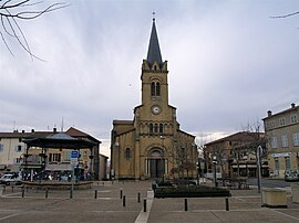 Place de la libération in Le Bois-d'Oingt | |
Location of Val d'Oingt  | |
 Val d'Oingt | |
| Coordinates: 45°55′16″N 4°35′10″E / 45.9211°N 4.5861°ECoordinates: 45°55′16″N 4°35′10″E / 45.9211°N 4.5861°E | |
| Country | France |
| Region | Auvergne-Rhône-Alpes |
| Department | Rhône |
| Arrondissement | Villefranche-sur-Saône |
| Canton | Val d'Oingt |
| Government | |
| • Mayor (2020–2026) | Pascal Terrier |
| Area 1 | 18.1 km2 (7.0 sq mi) |
| Population (Jan. 2018)[1] | 4,088 |
| • Density | 230/km2 (580/sq mi) |
| Time zone | UTC+01:00 (CET) |
| • Summer (DST) | UTC+02:00 (CEST) |
| INSEE/Postal code | 69024 /69620 |
| Elevation | 250–652 m (820–2,139 ft) |
| 1 French Land Register data, which excludes lakes, ponds, glaciers > 1 km2 (0.386 sq mi or 247 acres) and river estuaries. | |


Val d'Oingt (French pronunciation: [val dwɛ̃], literally Valley of Oingt) is a commune located in the department of Rhône in the Auvergne-Rhône-Alpes region, in eastern France, established on 1 January 2017 by the merger of former communes of Le Bois-d'Oingt, Oingt and Saint-Laurent-d'Oingt.[2]
See also[]
References[]
- ^ "Populations légales 2018". The National Institute of Statistics and Economic Studies. 28 December 2020.
- ^ (in French) Arrêté du 22 septembre 2016 portant création de la commune nouvelle de Val d'Oingt, Journal officiel.
| Wikimedia Commons has media related to Val d'Oingt. |
This Rhône geographical article is a stub. You can help Wikipedia by . |
Categories:
- Communes of Rhône (department)
- Rhône (department) geography stubs