Châtillon, Rhône
show This article may be expanded with text translated from the corresponding article in French. (July 2014) Click [show] for important translation instructions. |
Châtillon | |
|---|---|
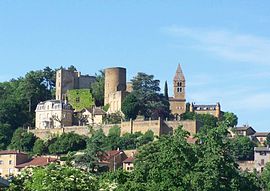 The village of Châtillon d'Azergues | |
 Coat of arms | |
show Location of Châtillon | |
 Châtillon | |
| Coordinates: 45°52′41″N 4°38′46″E / 45.8781°N 4.6461°ECoordinates: 45°52′41″N 4°38′46″E / 45.8781°N 4.6461°E | |
| Country | France |
| Region | Auvergne-Rhône-Alpes |
| Department | Rhône |
| Arrondissement | Villefranche-sur-Saône |
| Canton | Val d'Oingt |
| Intercommunality | Beaujolais Pierres Dorées |
| Government | |
| • Mayor (2020–2026) | Bernard Marconnet[1] |
| Area 1 | 10.71 km2 (4.14 sq mi) |
| Population (Jan. 2018)[2] | 2,117 |
| • Density | 200/km2 (510/sq mi) |
| Time zone | UTC+01:00 (CET) |
| • Summer (DST) | UTC+02:00 (CEST) |
| INSEE/Postal code | 69050 /69380 |
| Elevation | 199–334 m (653–1,096 ft) (avg. 216 m or 709 ft) |
| 1 French Land Register data, which excludes lakes, ponds, glaciers > 1 km2 (0.386 sq mi or 247 acres) and river estuaries. | |


Châtillon (French pronunciation: [ʃatijɔ̃] (![]() listen)), formerly known as Châtillon-d'Azergues, is a commune in the Rhône département in eastern France.
listen)), formerly known as Châtillon-d'Azergues, is a commune in the Rhône département in eastern France.
Sites and monuments[]

The Château de Châtillon-d'Azergues, a ruined 13th to 15th century castle, dominates the village. The 12th century Chapel of Saint-Barthélémy, known as Notre-Dame-de-Bon-Secours, is at the side of the castle.
The chapel was listed in 1862 as a monument historique by the French Ministry of Culture; the castle itself has been listed since 1937.[3]
See also[]
Communes of the Rhône department
References[]
- ^ "Répertoire national des élus: les maires". data.gouv.fr, Plateforme ouverte des données publiques françaises (in French). 2 December 2020.
- ^ "Populations légales 2018". INSEE. 28 December 2020.
- ^ Base Mérimée: Châtillon: Château et sa chapelle, Ministère français de la Culture. (in French)
| Wikimedia Commons has media related to Châtillon (Rhône). |
| show Authority control |
|---|
This Rhône geographical article is a stub. You can help Wikipedia by . |
Categories:
- Communes of Rhône (department)
- Rhône (department) geography stubs