Chessy, Rhône
show This article may be expanded with text translated from the corresponding article in French. (July 2014) Click [show] for important translation instructions. |
Chessy-les-Mines | |
|---|---|
 The entrance of the château | |
 Coat of arms | |
show Location of Chessy-les-Mines | |
 Chessy-les-Mines | |
| Coordinates: 45°53′17″N 4°37′27″E / 45.8881°N 4.6242°ECoordinates: 45°53′17″N 4°37′27″E / 45.8881°N 4.6242°E | |
| Country | France |
| Region | Auvergne-Rhône-Alpes |
| Department | Rhône |
| Arrondissement | Villefranche-sur-Saône |
| Canton | Val d'Oingt |
| Intercommunality | Beaujolais Pierres Dorées |
| Government | |
| • Mayor (2020–2026) | Thierry Padilla |
| Area 1 | 4.55 km2 (1.76 sq mi) |
| Population (Jan. 2018)[1] | 2,085 |
| • Density | 460/km2 (1,200/sq mi) |
| Time zone | UTC+01:00 (CET) |
| • Summer (DST) | UTC+02:00 (CEST) |
| INSEE/Postal code | 69056 /69380 |
| Elevation | 211–342 m (692–1,122 ft) (avg. 205 m or 673 ft) |
| 1 French Land Register data, which excludes lakes, ponds, glaciers > 1 km2 (0.386 sq mi or 247 acres) and river estuaries. | |


Chessy (French: [ʃɛsi] (![]() listen)), also known as Chessy-les-Mines ([ʃɛsi le min]), is a commune in the Rhône department in eastern France.
listen)), also known as Chessy-les-Mines ([ʃɛsi le min]), is a commune in the Rhône department in eastern France.
Chessy-les-Mines is the type locality of the mineral azurite, also known as "chessylite."[2] The species was redescribed and renamed in 1824 by François-Sulpice Beudant (1787–1850), French mineralogist and geologist.[3]
See also[]
References[]
- ^ "Populations légales 2018". INSEE. 28 December 2020.
- ^ Chessy-les-Mines at Mindat.org
- ^ Muséum national d'histoire naturelle Archived July 14, 2011, at the Wayback Machine
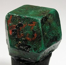

Azurite from Chessy. Specimen from first half of 19th century.
External links[]
| Wikimedia Commons has media related to Chessy (Rhône). |
- Photo gallery of Chessy mines & minerals
- Photo of a classic Chessy azurite at Muséum national d'histoire naturelle
| show Authority control |
|---|
This Rhône geographical article is a stub. You can help Wikipedia by . |
Categories:
- Communes of Rhône (department)
- Rhône (department) geography stubs