Le Bois-d'Oingt
show This article may be expanded with text translated from the corresponding article in French. (July 2014) Click [show] for important translation instructions. |
Le Bois-d'Oingt | |
|---|---|
Part of Val d'Oingt | |
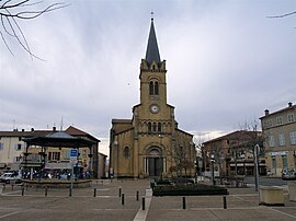 Place de la libération in Le Bois-d'Oingt | |
 Coat of arms | |
show Location of Le Bois-d'Oingt | |
 Le Bois-d'Oingt | |
| Coordinates: 45°55′16″N 4°35′10″E / 45.9211°N 4.5861°ECoordinates: 45°55′16″N 4°35′10″E / 45.9211°N 4.5861°E | |
| Country | France |
| Region | Auvergne-Rhône-Alpes |
| Department | Rhône |
| Arrondissement | Villefranche-sur-Saône |
| Canton | Le Bois-d'Oingt |
| Commune | Val d'Oingt |
| Area 1 | 5.13 km2 (1.98 sq mi) |
| Population (2017)[1] | 2,503 |
| • Density | 490/km2 (1,300/sq mi) |
| Demonym(s) | Buisantins, Buisantines |
| Time zone | UTC+01:00 (CET) |
| • Summer (DST) | UTC+02:00 (CEST) |
| Postal code | 69620 |
| Elevation | 250–466 m (820–1,529 ft) (avg. 300 m or 980 ft) |
| 1 French Land Register data, which excludes lakes, ponds, glaciers > 1 km2 (0.386 sq mi or 247 acres) and river estuaries. | |


Le Bois-d'Oingt (French pronunciation: [lə bwa dwɛ̃], literally The Wood of Oingt) is a former commune located in the Rhône in the Auvergne-Rhône-Alpes region, in eastern France. On 1 January 2017, Le Bois-d'Oingt, Oingt and Saint-Laurent-d'Oingt merged becoming one commune of Val d'Oingt.[2]
Geography[]
Le Bois d'Oingt's acreage is of 1.976 square mile (512 hectares), and it lies at 350 meters altitude.
The inhabitants of Bois d’Oingt are called the “buisantins”.
See also[]
References[]
| Wikimedia Commons has media related to Le Bois-d'Oingt. |
| show Authority control |
|---|
This Rhône geographical article is a stub. You can help Wikipedia by . |
Categories:
- Former communes of Rhône (department)
- Rhône (department) geography stubs