Cova Lima Municipality
This article may be expanded with text translated from the corresponding article in German. (July 2011) Click [show] for important translation instructions.
|
This article needs additional citations for verification. (February 2017) |
Cova Lima
Kovalima | |
|---|---|
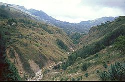 Mountain area in Cova Lima | |
 Map of East Timor highlighting Cova Lima Municipality | |
| Coordinates: 9°19′S 125°15′E / 9.317°S 125.250°ECoordinates: 9°19′S 125°15′E / 9.317°S 125.250°E | |
| Country | |
| Capital | Suai |
| Administrative posts | |
| Area | |
| • Total | 1,203 km2 (464 sq mi) |
| Area rank | 7th |
| Population (2015 census) | |
| • Total | 65,301 |
| • Rank | 9th |
| • Density | 54/km2 (140/sq mi) |
| • Density rank | 9th |
| Households (2015 census) | |
| • Total | 12,564 |
| • Rank | 8th |
| Time zone | UTC+09:00 (TLT) |
| ISO 3166 code | TL-CO |
| HDI (2017) | 0.618[1] medium · 3rd |


Cova Lima (Portuguese: Município Cova Lima, Tetum: Munisípiu Kovalima) is a municipality of East Timor, in the Southwest part of the country. It has a population of 59,455 (Census 2010) and an area of 1,230 km2.[2] The capital of the municipality is Suai, which lies 136 km from Dili, the national capital.[3] The administrative posts of Cova Lima are Fatululic, , , Zumalai, , Suai, and Tilomar.[4]
Cova Lima borders the Timor Sea to the south, the municipalities of Bobonaro to the north, Ainaro to the east, and the Indonesian province of Nusa Tenggara Timur to the west.
Subdivisions of Cova Lima
Cities and rivers of Cova Lima


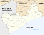
Borders of Cova Lima until 2003.

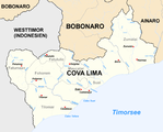
Borders of Cova Lima since 2003.

References[]
Notes[]
- ^ "Sub-national HDI - Area Database - Global Data Lab". hdi.globaldatalab.org. Retrieved 2018-09-13.
- ^ "Friends of Suai/Covalima" (PDF). City of Port Phillip. May 2014. Retrieved 2017-02-22.
- ^ "Friends of Suai: Strategic Plan: 2010 to 2020" (PDF). City of Port Phillip. Retrieved 2017-02-22.
- ^ Gunn, Geoffrey C (2011). Historical Dictionary of East Timor. Lanham, Maryland: Scarecrow Press. p. 67. ISBN 9780810867543.
Bibliography[]
- Barrkman, Joanna (2014). The Textiles of Covalima, Timor-Leste. Dili: Governo de Timor-Leste. ISBN 9789898726261. Retrieved 26 October 2018.
This East Timor location article is a stub. You can help Wikipedia by . |
- Cova Lima Municipality
- Municipalities of East Timor
- East Timor geography stubs