Crans-Montana
Crans-Montana | |
|---|---|
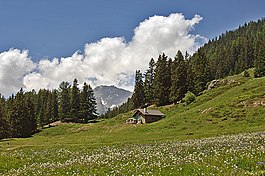 Panorama, Crans-Montana, Switzerland | |
 Coat of arms | |
show Location of Crans-Montana | |
 Crans-Montana | |
| Coordinates: 46°19′N 7°29′E / 46.317°N 7.483°ECoordinates: 46°19′N 7°29′E / 46.317°N 7.483°E | |
| Country | Switzerland |
| Canton | Valais |
| District | Sierre |
| Area | |
| • Total | 59.66 km2 (23.03 sq mi) |
| Highest elevation (Schneehorn) | 3,177 m (10,423 ft) |
| Population (2018-12-31)[1] | |
| • Total | 10,447 |
| • Density | 180/km2 (450/sq mi) |
| Time zone | UTC+01:00 (Central European Time) |
| • Summer (DST) | UTC+02:00 (Central European Summer Time) |
| Postal code(s) | 3971 Chermignon 3963 Crans-sur-Sierre 3971 Ollon 3963 Montana 3974 Mollens 3975 Randogne |
| SFOS number | 6253 |
| Surrounded by | Lens, Icogne, Sierre |
| Website | http://www.commune-cransmontana.ch/ SFSO statistics |


Crans-Montana is a municipality in the district of Sierre in the canton of Valais, Switzerland. On 1 January 2017 the former municipalities of Chermignon, Mollens, Montana and Randogne merged to form the new municipality of Crans-Montana.[2] Crans-Montana is also a ski resort that was created through the fusion of the two centers of Crans and Montana and belonged to six municipalities (Chermignon, Icogne, Lens, Mollens, Montana and Randogne), four of which merged to form the municipality of Crans-Montana.
History[]
Chermignon[]
Chermignon is first mentioned in 1228 as Chermenon and Chirminon.[3] It became an independent municipality in 1905 when it separated from Lens.[4]
Mollens[]
Mollens is first mentioned about 1250 as Molaen. In 1286 it was mentioned as Moleing. The municipality was formerly known by its German name Molei, however, that name is no longer used.[5]
Montana[]
Montana is first mentioned in 1243 as Montana.[6] In 1905 it separated from Lens to form an independent municipality.[4]
Randogne[]
Randogne is first mentioned in 1224 as Randonni.[7]
Ski resort[]

The resort is located in the heart of the Swiss Alps in the French-speaking part of the canton of Valais. It is located on a plateau above Sierre at an elevation of about 1,500 m (4,920 ft) above sea level, allowing good view over the Valais Alps and Weisshorn in particular. The resort is a fusion of the two centers of Crans and Montana and belongs to 6 municipalities (Chermignon, Icogne, Lens, Mollens, Montana and Randogne).
The skiing area of Crans-Montana is composed of 140 km (87 mi) of pistes, and includes the Plaine Morte Glacier. It is topped by the Pointe de la Plaine Morte at 2,927 m (9,600 ft).
Crans-Montana is famous in alpine ski racing for the 1987 World Championships and is often on the World Cup schedule, usually for women's speed events.
Other activities[]
The area hosts the winter mountain pop rock festival, the , and a professional golf tournament, the European Tour's Omega European Masters, which takes place each September. The area has also been frequently used for bicycle racing, hosting stage finishes of the Tour de Suisse seven times and of the Tour de Romandie eight times as of 2013. In addition Crans-Montana also hosted the finish of the 20th stage of the 1984 Tour de France, won by Laurent Fignon, who also took the overall race win that year.[8]
The has four courses, one designed by Seve Ballesteros and another named after Jack Nicklaus.[9]
The international renowned Les Roches International School of Hotel Management is located in Crans-Montana. [10]
Geography[]
Crans-Montana has an area, as of 2009, of 59.66 km2 (23.03 sq mi).[11]
Population[]
The new municipality has a population (as of December 2019) of 10,365.[12]
Historic population[]
The historical population is given in the following chart:[13]

Heritage sites of national significance[]
The Roches des Fées and the Hotel Bella Lui are listed as Swiss heritage site of national significance.[14]
Climate[]
Between 1961 and 1990 Montana had an average of 110.5 days of rain or snow per year and on average received 982 mm (38.7 in) of precipitation. The wettest month was December during which time Montana received an average of 120 mm (4.7 in) of rain or snow. During this month there was precipitation for an average of 9.9 days. The month with the most days of precipitation was January, with an average of 10.4, but with only 108 mm (4.3 in) of rain or snow. The driest month of the year was September with an average of 51 mm (2.0 in) of precipitation over 6.8 days.[15]
| hideClimate data for Montana (1981–2010) | |||||||||||||
|---|---|---|---|---|---|---|---|---|---|---|---|---|---|
| Month | Jan | Feb | Mar | Apr | May | Jun | Jul | Aug | Sep | Oct | Nov | Dec | Year |
| Average high °C (°F) | 1.6 (34.9) |
2.2 (36.0) |
5.6 (42.1) |
9.2 (48.6) |
14.1 (57.4) |
17.7 (63.9) |
20.5 (68.9) |
19.8 (67.6) |
15.9 (60.6) |
11.6 (52.9) |
5.4 (41.7) |
2.3 (36.1) |
10.5 (50.9) |
| Daily mean °C (°F) | −1.8 (28.8) |
−1.7 (28.9) |
1.0 (33.8) |
4.2 (39.6) |
8.9 (48.0) |
12.2 (54.0) |
14.7 (58.5) |
14.2 (57.6) |
10.8 (51.4) |
7.1 (44.8) |
1.8 (35.2) |
−0.9 (30.4) |
5.9 (42.6) |
| Average low °C (°F) | −4.8 (23.4) |
−5 (23) |
−2.6 (27.3) |
0.3 (32.5) |
4.7 (40.5) |
7.6 (45.7) |
9.9 (49.8) |
9.8 (49.6) |
6.9 (44.4) |
3.8 (38.8) |
−1.1 (30.0) |
−3.8 (25.2) |
2.1 (35.9) |
| Average snowfall cm (inches) | 114.5 (45.1) |
94.4 (37.2) |
53.1 (20.9) |
33.4 (13.1) |
4.6 (1.8) |
0.4 (0.2) |
0 (0) |
0 (0) |
0.8 (0.3) |
8.1 (3.2) |
42.0 (16.5) |
84.5 (33.3) |
435.8 (171.6) |
| Average snowy days (≥ 1.0 cm) | 10.1 | 8.3 | 7.1 | 5.2 | 0.6 | 0.1 | 0 | 0 | 0.1 | 1.1 | 5.9 | 8.4 | 46.9 |
| Average relative humidity (%) | 67 | 67 | 66 | 64 | 66 | 67 | 66 | 69 | 72 | 70 | 70 | 68 | 68 |
| Mean monthly sunshine hours | 137 | 141 | 175 | 179 | 196 | 216 | 248 | 230 | 201 | 172 | 126 | 121 | 2,143 |
| Source: MeteoSwiss [16] | |||||||||||||
Notable people[]
- Elizabeth von Arnim (1866–1941), Australian-born British novelist, lived in Randogne 1910–1930
- Katherine Mansfield (1888–1923), New Zealand-born author, lived in Montana May 1921–January 1922
- Roger Moore (1927–2017), English actor, owned a chalet at the ski resort for many years after moving from Gstaad[when?]. He lived there until his death in 2017.
- Michel Roux (1941–2020), French-born chef and restaurateur who worked in England, lived in Crans-Montana from 2008.
- Golfers Adam Scott, Ángel Gallardo, Sergio García along with Francesco and Edoardo Molinari are residents.[vague]
References[]
- ^ "Ständige Wohnbevölkerung nach Staatsangehörigkeitskategorie Geschlecht und Gemeinde; Provisorische Jahresergebnisse; 2018". Federal Statistical Office. 9 April 2019. Retrieved 11 April 2019.
- ^ Amtliches Gemeindeverzeichnis der Schweiz published by the Swiss Federal Statistical Office (in German) accessed 27 April 2016
- ^ Chermignon in German, French and Italian in the online Historical Dictionary of Switzerland.
- ^ Jump up to: a b Amtliches Gemeindeverzeichnis der Schweiz published by the Swiss Federal Statistical Office (in German) accessed 19 July 2011
- ^ Mollens in German, French and Italian in the online Historical Dictionary of Switzerland.
- ^ Montana in German, French and Italian in the online Historical Dictionary of Switzerland.
- ^ Randogne in German, French and Italian in the online Historical Dictionary of Switzerland.
- ^ "Crans-Montana". Tour de Suisse. Archived from the original on 4 March 2014. Retrieved 4 March 2014.
- ^ Robbins, Tom (11 October 2019) Lone ranger: solo ski touring in Crans Montana in Financial Times. Retrieved 30 July 2020
- ^ "Hospitality & Leisure Management 2020".
- ^ Arealstatistik Standard - Gemeindedaten nach 4 Hauptbereichen
- ^ "Ständige und nichtständige Wohnbevölkerung nach institutionellen Gliederungen, Geburtsort und Staatsangehörigkeit". bfs.admin.ch (in German). Swiss Federal Statistical Office - STAT-TAB. 31 December 2019. Retrieved 6 October 2020.
- ^ Swiss Federal Statistical Office STAT-TAB Bevölkerungsentwicklung nach institutionellen Gliederungen, 1850-2000 (in German) accessed 27 April 2016
- ^ "Kantonsliste A-Objekte". KGS Inventar (in German). Federal Office of Civil Protection. 2009. Archived from the original on 28 June 2010. Retrieved 25 April 2011.
- ^ "Temperature and Precipitation Average Values-Table, 1961–1990" (in German, French, and Italian). Federal Office of Meteorology and Climatology - MeteoSwiss. Archived from the original on 27 June 2009. Retrieved 8 May 2009., the Montana weather station elevation is 1427 meters above sea level.
- ^ "Climate Norm Value Tables". Climate diagrams and normals from Swiss measuring stations. Federal Office of Meteorology and Climatology (MeteoSwiss). Archived from the original on 14 May 2013. Retrieved 5 February 2013. The weather station elevation is 1,427 meters above sea level.
External links[]
![]() Media related to Crans-Montana at Wikimedia Commons
Media related to Crans-Montana at Wikimedia Commons
- Official website
- Crans-Montana ski resort
- Cordona in German, French and Italian in the online Historical Dictionary of Switzerland.
| show Municipalities in Sierre District, Switzerland |
|---|
| show Authority control |
|---|
- Municipalities of Valais
- Cultural property of national significance in Valais
- Villages in Valais
- Ski areas and resorts in Switzerland