Crystal Range
| Crystal Range | |
|---|---|
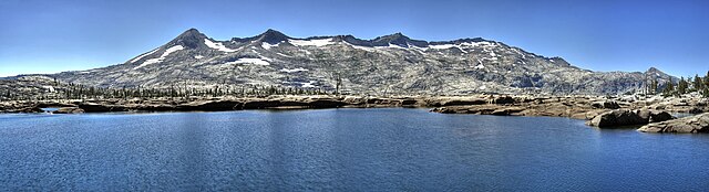
 Crystal Range and Gilmore Lake from Mount Tallac | |
| Highest point | |
| Peak | Pyramid Peak |
| Elevation | 9,985 ft (3,043 m)[1] |
| Geography | |
 location of Crystal Range in California | |
| Country | United States |
| State | California |
| District | El Dorado County |
| Range coordinates | 38°54′34.668″N 120°12′27.682″W / 38.90963000°N 120.20768944°WCoordinates: 38°54′34.668″N 120°12′27.682″W / 38.90963000°N 120.20768944°W[2] |
| Topo map | USGS Rockbound Valley |

The Crystal Range is a small chain of mountain peaks in the Desolation Wilderness in the U.S. state of California. It is a subrange of the Sierra Nevada. The highest and most southerly peak is Pyramid Peak at 9985 ft;[1] Mount Agassiz is next north at 9967 ft, with Mount Price (9975 ft) rounding out the southern group of peaks. Tells Peak is the northernmost named peak in the range.
It is southwest of Lake Tahoe and north of U.S. Route 50. Two main access roads run off of U.S. Route 50 at Ice House Road and Wright's Lake Road.
See also[]
- The Crystal Range seen from west of Sacramento (Pyramid Peak at center).
References[]
- ^ a b "Pyramid". NGS data sheet. U.S. National Geodetic Survey. Retrieved 2012-11-06.
- ^ "Crystal Range". Geographic Names Information System. United States Geological Survey. Retrieved 2009-05-04.
This El Dorado County, California–related article is a stub. You can help Wikipedia by . |
Categories:
- Mountains of the Desolation Wilderness
- Mountain ranges of Northern California
- El Dorado County, California geography stubs