Pyramid Peak (California)
| Pyramid Peak | |
|---|---|
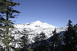 Pyramid Peak as seen from near Mount Ralston: the summit route goes up the left ridge. | |
| Highest point | |
| Elevation | 9,985 ft (3,043 m) NAVD 88[1] |
| Prominence | 2,583 ft (787 m)[2] |
| Listing |
|
| Coordinates | 38°50′42″N 120°09′28″W / 38.8450219167°N 120.1579001028°WCoordinates: 38°50′42″N 120°09′28″W / 38.8450219167°N 120.1579001028°W[1] |
| Geography | |
| Location | El Dorado County, California, U.S. |
| Parent range | Sierra Nevada |
| Topo map | USGS Pyramid Peak |
| Climbing | |
| Easiest route | Scramble, class 2[3] |

Pyramid Peak is a mountain in the California's Sierra Nevada in the Crystal Range to the west of Lake Tahoe. It is the highest point in the Desolation Wilderness.[2] With an elevation gain of almost 4,100 feet (1,250 m), the Rocky Canyon route is the mountain's most popular approach although it is very arduous. To the east, at the base of the peak, lies Pyramid Lake.
References[]
- ^ a b "Pyramid". NGS data sheet. U.S. National Geodetic Survey. Retrieved 2009-08-14.
- ^ a b "Pyramid Peak, California". Peakbagger.com. Retrieved 2009-08-14.
- ^ a b "Sierra Peaks Section List" (PDF). Angeles Chapter, Sierra Club. Retrieved 2009-08-14.
- ^ "Tahoe OGUL Peaks List". Retrieved 2021-11-07.

External links[]
- "Pyramid Peak". Geographic Names Information System. United States Geological Survey.
- "Pyramid Peak". SummitPost.org.
- Alpine Ski Tours - Lake Tahoe: Southwest Topographic Map
Sierra Nevada | |||||||||
|---|---|---|---|---|---|---|---|---|---|
| Peaks above 14,000 ft | |||||||||
| Other notable peaks (Peak list • First ascents) |
| ||||||||
| Passes | |||||||||
| Rivers | |||||||||
| Lakes | |||||||||
| Protected areas (main article) |
| ||||||||
| Communities | |||||||||
| Ski areas | |||||||||
| Trails | |||||||||

This El Dorado County, California–related article is a stub. You can help Wikipedia by . |
Categories:
- Mountains of the Desolation Wilderness
- North American 3000 m summits
- Mountains of El Dorado County, California
- El Dorado County, California geography stubs