Sonora Pass
| Sonora Pass | |
|---|---|
 | |
| Elevation | 9,624 ft (2,933 m) |
| Traversed by | |
| Location | Mono / Tuolumne / Alpine counties, California, United States[1] |
| Range | Sierra Nevada |
| Coordinates | 38°19′40″N 119°38′9″W / 38.32778°N 119.63583°WCoordinates: 38°19′40″N 119°38′9″W / 38.32778°N 119.63583°W |
 Location in California | |
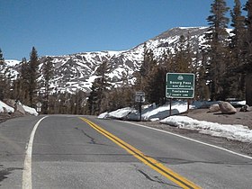
Sonora Pass (el. 9,624 ft. / 2,933 m.) is the second-highest highway pass in the Sierra Nevada,[2] lower by 321 ft. (about 98 m.) than Tioga Pass to the south.[3] State Route 108 traverses the pass.


Description[]
The pass connects the communities of Sonora to the west and Bridgeport to the east. Like Ebbetts Pass to the north and Tioga Pass to the south, the highway closes during winter, generally between November and May, due to snow accumulation.[4]
The highway over the pass is extremely steep (exceeding 8% for most of the traverse, and up to 26% grades in some locations), narrow and winding between Kennedy Meadows on the west side and Leavitt Meadows on the east. The route is not recommended for vehicles or vehicle combinations that are unusually wide, heavy or long.[5]

The Pacific Crest Trail, a 2,650 mile (4,240 km) long National Scenic Trail, crosses Highway 108 at Sonora Pass.[6]
Adjacent to the Pass is a picnic/parking area, which serves as a day-use rest stop or a trailhead for hikes to nearby Sonora Peak, Wolf Creek Lake, and other spots north or south along the Pacific Crest Trail.
History[]
The first documented immigrant traverse of Sonora Pass appears to have been in the late summer of 1852 by a wagon train known as the Clark-Skidmore Company. Subsequently, merchant interests in the communities of Sonora and Columbia promoted the route to California-bound immigrants, not always with happy results when immigrants discovered how difficult it was.[7] There are some references indicating the earliest immigrant crossing was in 1841 by the Bartleson-Bidwell Party, but the U.S. Forest Service indicates they crossed north of Sonora Pass in the Carson-Iceberg area.[8][9]
With the discovery of deposits and development of silver and gold mining east of the Sierra Nevada in the beginning of the 1860s, merchant interests in the counties on both sides of the pass pushed for development of a road that would enable them to improve transportation and trade. Surveying for a road through Sonora Pass began in 1863 and the road was in use by 1865.[10]
In the 1880s the California and Nevada Railroad and its predecessor, the California and Mount Diablo Railroad, proposed to run a narrow gauge railroad over Sonora Pass with a line running from Emeryville - Stockton and then connecting with the Denver and Rio Grande Railroad in Utah. The railroad never built track beyond the San Francisco Bay Area.
The Baker Highway Maintenance Station, on 108 to the west of the summit, kept the road open during the summer; it is closed in the winter, and is listed on the National Register of Historic Places.
In popular media[]
In 1935, MGM Art Director David Townsend (art director) was killed when the car he was riding in left the road at Sonora Pass. Lowell L. Ralph, Mrs. Lottie Mundello, and Miss Agnes McMullen survived after being thrown from the car. They were there scouting filming locations for the upcoming film Robin Hood of El Dorado (film).
In 1943, the location scenes for the mountainous hideout of the Republican Spanish guerilla band in For Whom the Bell Tolls were filmed here.
| Wikimedia Commons has media related to Sonora Pass. |
References[]
- ^ "Sonora Pass, CA". USGS Quad maps. TopoQuest.com. Retrieved 2008-09-20.
- ^ "Highways and Major Roads Through the Sierra Nevada". Sierra Nevada Photos. Archived from the original on 2009-05-17. Retrieved 2008-09-20.
- ^ "Highways and Major Roads Through the Sierra Nevada". Sierra Nevada Photos. Archived from the original on 2009-05-17. Retrieved 2008-09-20.
- ^ "Road Information - Winter Driving Tips - Mountain Pass Closures". Caltrans. Archived from the original on 2008-10-16. Retrieved 2008-09-20.
- ^ "Picture of advisory sign on State Route 108". Retrieved 2008-09-20.
- ^ "Sonora Pass, CA". USGS Quad maps. TopoQuest.com. Retrieved 2008-09-20.
- ^ "Sonora Pass". Archived from the original on July 25, 2008. Retrieved 2008-09-20.
- ^ "Recreation Activities: Carson-Iceberg Wilderness". US Forest Service. Retrieved 2008-09-20.
- ^ "Sonora Pass, Mono County, California". Retrieved 2008-09-20.
- ^ Farquhar, Francis Peloubet (1965). History of the Sierra Nevada. University of California Press. p. 102. ISBN 0-520-01551-7. Retrieved 2008-09-20.
sonora pass railroad.
| Peaks above 14,000 ft | |||||||||
|---|---|---|---|---|---|---|---|---|---|
| Other notable peaks (Peak list • First ascents) |
| ||||||||
| Passes | |||||||||
| Rivers | |||||||||
| Lakes | |||||||||
| Protected areas (main article) |
| ||||||||
| Communities | |||||||||
| Ski areas | |||||||||
| Trails | |||||||||

- Landforms of Mono County, California
- Mountain passes of the Sierra Nevada (United States)
- Transportation in Tuolumne County, California
- Landforms of Tuolumne County, California
- Transportation in Mono County, California