Lake Isabella
This article needs additional citations for verification. (November 2010) |
| Lake Isabella | |
|---|---|
 Satellite image of Lake Isabella | |
 Lake Isabella | |
| Location | Kern County, California, United States |
| Coordinates | 35°40′17.69″N 118°25′38.05″W / 35.6715806°N 118.4272361°WCoordinates: 35°40′17.69″N 118°25′38.05″W / 35.6715806°N 118.4272361°W |
| Lake type | reservoir |
| Primary inflows | Upper Kern River, South Fork Kern River |
| Primary outflows | Lower Kern River |
| Basin countries | United States |
| Surface area | 11,000 acres (4,500 ha) |
| Water volume | 568,000 acre-feet (701,000 dam3) |
| Surface elevation | 2,500 ft (760 m) |


Lake Isabella also called Isabella Lake,[1][2] is a reservoir in Kern County, California, United States created by the earthen Isabella Dam. It was formed in 1953 when the U.S. Army Corps of Engineers dammed the Kern River at the junction of its two forks at Whiskey Flat. At 11,000 acres (4,500 ha), it is one of the larger reservoirs in California. The area is in the southern end of the Sierra Nevada range and the lake itself is located in low mountains at an elevation of approximately 2,500 ft (760 m) where summer temperatures reach over 100 °F (38 °C) but low enough to avoid winter snows on the surrounding ridges. Lake Isabella is located about 40 miles (64 km) northeast of Bakersfield, and is the main water supply for that city. Lake Isabella can be reached by car from Bakersfield via state Highway 178 and from Delano via Highway 155. The former towns of Isabella and Kernville were flooded by the newly created reservoir.
Isabella Dam deficiency[]
In 2006, Isabella Dam was found to be too unstable to hold a full amount of water and approximately 40% of a full reservoir had to be let out to restabilize the earth works.[citation needed] Presently the U.S. Army Corps of Engineers won't let the water get above 60% of capacity until an estimated 10–15 years of studies and repairs are made.(completion date needed) To further add to this problem the Isabella Dam bisects an active fault that could lead to a catastrophic failure if an earthquake occurs along it. This fault was considered inactive when the site was studied in the late 1940s.
Recreation[]
The dam is operated by the U.S. Army Corps of Engineers and several recreation areas are located around the lake as a part of the [[Sequoia National Forest. The nearby towns of Lake Isabella and Kernville receive economic benefit from tourism created by the Lake Isabella Recreation Area[3] and the whitewater rafting attraction of the Upper and Lower Kern River. Much of the land surrounding the lake is part of the Sequoia National Forest.
Gallery[]


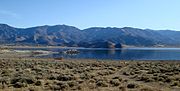
Southern shore of Lake Isabella.
The southeast fork, viewed from the north shore with Weldon to the left.

Facing west and taken from the eastern shore between the forks.

Shore near town of Lake Isabella.

Mountain Mesa viewed from the north side of the lake.
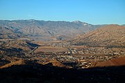
View of the lake from the hills west of Bodfish.

View from Pioneer Point at full moon rise


See also[]
- Sequoia National Forest
- List of dams and reservoirs in California
- List of lakes in California
- List of largest reservoirs of California
- Erskine Fire
External links[]
- Corps of Engineers Water Releases and Lake Level Information
- Lake Isabella Recreation - Sequoia National Forest
References[]
- ^ U.S. Geological Survey Geographic Names Information System: Isabella Lake
- ^ Durham, David L. (2000). Durham's Place Names of Central California: Includes Madera, Fresno, Tulare, Kings & Kern Counties. Quill Driver Books. p. 132. ISBN 978-1-884995-33-0.
- ^ "Kern County Public Health warns residents of harmful algal blooms in Lake Isabella". KGET 17. Retrieved 2020-06-07.
| Wikimedia Commons has media related to Lake Isabella. |
- Reservoirs in Kern County, California
- Kern River
- Kern River Valley
- Lakes of the Sierra Nevada (U.S.)
- Sequoia National Forest
- Reservoirs in California
- Reservoirs in Southern California