Curahuasi District
Curahuasi
Qura Wasi | |
|---|---|
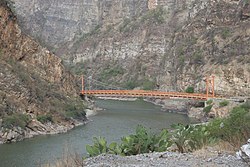 Bridge across the Apurímac River on the border of the regions Cusco and Apurímac between the districts Curahuasi and Mollepata | |
| Country | |
| Region | Apurímac |
| Province | Abancay |
| Founded | January 2, 1857 |
| Capital | Curahuasi |
| Government | |
| • Mayor | Danilo Valenza Calvo |
| Area | |
| • Total | 817.98 km2 (315.82 sq mi) |
| Elevation | 2,688 m (8,819 ft) |
| Population (2005 census) | |
| • Total | 18,556 |
| • Density | 23/km2 (59/sq mi) |
| Time zone | UTC-5 (PET) |
| UBIGEO | 030104 |
Curahuasi District is one of the nine districts of the Abancay Province in Peru.[1]
Geography[]
One of the highest peaks of the district is Q'illu Q'asa at approximately 4,600 m (15,100 ft). Other mountains are listed below:[2]
- Aqu Q'asa
- Chaka Chaka
- Chunkara
- Chuqi Marka
- Ch'illkani
- Ch'uru
- Chhullunku Pata
- Inka Pirqa
- Kiska Pata
- Kunturillu
- Mulli Kamayuq
- Mulliyuq
- Muru Qucha
- Nasa Q'ara
- Pirwata
- Puka T'uyuyuq
- Pukara
- Quri Phaqcha
- Q'iwiri
- Silla Q'asa
- Tika Qaqa
- T'asta Q'asa
- T'utura Qucha
- Urpi Utt'aña
- Urquni
- Waman Ayri
- Waman Marka
- Wank'a Wank'a
- Warmi Awqa
- Wasa Qhata
- Wichinka
- Wik'uña Kunka
- Wik'uña Utt'aña
- Yana Qucha
Ethnic groups[]
The people in the district are mainly indigenous citizens of Quechua descent, although with a sizable percentage of mestizo and castizo population located mainly in the urban center.
Quechua is the language which the majority of the population (73.79%) learnt to speak in childhood, 25.86% of the residents started speaking using the Spanish language (2007 Peru Census).[3]
See also[]
References[]
- ^ (in Spanish) Instituto Nacional de Estadística e Informática. Banco de Información Digital Archived April 23, 2008, at the Wayback Machine. Retrieved April 4, 2008.
- ^ escale.minedu.gob.pe/ UGEL map Abancay Province (Apurimac Region)
- ^ inei.gob.pe Archived January 27, 2013, at the Wayback Machine INEI, Peru, Censos Nacionales 2007, Frequencias: Preguntas de Población: Idioma o lengua con el que aprendió hablar (in Spanish)
Coordinates: 14°03′43″S 72°40′12″W / 14.062°S 72.670°W

This Apurímac Region geography article is a stub. You can help Wikipedia by . |
Categories:
- Districts of the Abancay Province
- Districts of the Apurímac Region
- Apurímac Region geography stubs