Cussewago Creek
| Cussewago Creek Tributary to French Creek | |
|---|---|
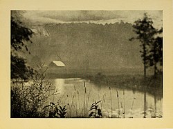 A 1922 photograph of Cussewago Creek | |
 Location of Cussewago Creek mouth | |
| Location | |
| Country | United States |
| States | Pennsylvania |
| Counties | Crawford Erie |
| Physical characteristics | |
| Source | divide between Cussewago Creek and Elk Creek |
| • location | about 0.25 miles north of Eureka Corners, Pennsylvania |
| • coordinates | 41°54′33″N 080°12′08″W / 41.90917°N 80.20222°W[1] |
| • elevation | 1,315 ft (401 m)[2] |
| Mouth | French Creek |
• location | Meadville, Pennsylvania[2] |
• coordinates | 41°38′21″N 080°09′44″W / 41.63917°N 80.16222°WCoordinates: 41°38′21″N 080°09′44″W / 41.63917°N 80.16222°W[1] |
• elevation | 1,063 ft (324 m)[1] |
| Length | 35.08 mi (56.46 km)[3] |
| Basin size | 97.29 square miles (252.0 km2)[4] |
| Discharge | |
| • location | French Creek |
| • average | 166.02 cu ft/s (4.701 m3/s) at mouth with French Creek[4] |
| Basin features | |
| Progression | south |
| River system | Allegheny River |
| Tributaries | |
| • left | Spring Run |
| • right | West Branch Cussewago Creek Carr Run |
| Bridges | I-86, Hazen Road, North Road, Findley Lake Road, Greenman Road, I-86, Station Road, Ashton Road, NY 89, Wildman Road, Knoyle Road, Jones Road, PA 89, |


Cussewago Creek is a 35.08 mi (56.46 km) long tributary to French Creek that is classed as a 4th order stream on the EPA waters geoviewer site.[3]
Variant names[]
According to the Geographic Names Information System, it has also been known historically as:[1]
- Cassewago Creek
- Kossewago Creek
The name of the creek is alleged to come from the aboriginal inhabitants, and is said to mean, "big belly".[5]
Course[]
Cussewago Creek rises north of Eureka Springs in Erie County, Pennsylvania and flows south into Crawford County, Pennsylvania to meet French Creek at Meadville.
Watershed[]
Cussewago Creek drains 97.29 square miles (252.0 km2) of Erie Drift Plain (glacial geology). The watershed receives an average of 45.4 in/year of precipitation and has a wetness index of 492.71.[4] The watershed is about 44% forested.
Natural History[]
Cussewago Creek supports a diverse fauna, including mammals, amphibians, fishes, and mollusks.[6]
See also[]
References[]
- ^ Jump up to: a b c d "GNIS Detail - Cussewago Creek". geonames.usgs.gov. US Geological Survey. Retrieved 22 September 2019.
- ^ Jump up to: a b "Cussewago Creek Topo Map, Crawford County PA (Meadville Area)". TopoZone. Locality, LLC. Retrieved 22 September 2019.
- ^ Jump up to: a b "ArcGIS Web Application". epa.maps.arcgis.com. US EPA. Retrieved 22 September 2019.
- ^ Jump up to: a b c "Cussewago Creek Watershed Report". Waters Geoviewer. US EPA. Retrieved 22 September 2019.
- ^ [1]
- ^ [2]
| Authority control |
|---|
- Rivers of Pennsylvania
- Tributaries of the Allegheny River
- Rivers of Crawford County, Pennsylvania