Dahlem, North Rhine-Westphalia
Dahlem | |
|---|---|
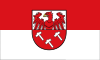 Flag  Coat of arms | |
show Location of Dahlem within Euskirchen district | |
 Dahlem | |
| Coordinates: 50°22′59″N 06°32′59″E / 50.38306°N 6.54972°ECoordinates: 50°22′59″N 06°32′59″E / 50.38306°N 6.54972°E | |
| Country | Germany |
| State | North Rhine-Westphalia |
| Admin. region | Köln |
| District | Euskirchen |
| Government | |
| • Mayor (2020–25) | Jan Lembach[1] (CDU) |
| Area | |
| • Total | 95.18 km2 (36.75 sq mi) |
| Elevation | 539 m (1,768 ft) |
| Population (2020-12-31)[2] | |
| • Total | 4,301 |
| • Density | 45/km2 (120/sq mi) |
| Time zone | UTC+01:00 (CET) |
| • Summer (DST) | UTC+02:00 (CEST) |
| Postal codes | 53949 |
| Dialling codes | 02447 |
| Vehicle registration | EU |
| Website | www.dahlem.de |
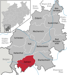


Dahlem is a municipality in the district of Euskirchen. It has the lowest population density and population of all municipalities of in the state of North Rhine-Westphalia, Germany. It is located in the Eifel hills, approx. 35 km south-west of Euskirchen. The small medieval town Kronenburg is part of the municipality.
Geography[]
Dahlem is located in the northern Eifel region in the High Fens – Eifel Nature Park between Blankenheim in the Northeast and Stadtkyll the southwest. The Kyll flows through the region from the . The Heidenköpfe lie in the Ripsdorfer forest to the east.
References[]
- ^ Wahlergebnisse in NRW Kommunalwahlen 2020, Land Nordrhein-Westfalen, accessed 19 June 2021.
- ^ "Bevölkerung der Gemeinden Nordrhein-Westfalens am 31. Dezember 2020" (in German). Landesbetrieb Information und Technik NRW. Retrieved 21 June 2021.
| show Towns and municipalities in Euskirchen (district) |
|---|
| Authority control |
|---|
This Euskirchen district location article is a stub. You can help Wikipedia by . |
Categories:
- Municipalities in North Rhine-Westphalia
- Euskirchen (district)
- Cologne region geography stubs