Nettersheim
Nettersheim | |
|---|---|
 Coat of arms | |
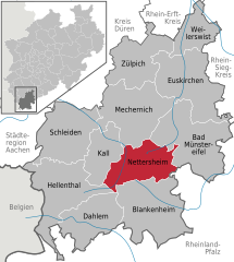
show Location of Nettersheim within Euskirchen district | |
 Nettersheim | |
| Coordinates: 50°29′33″N 6°37′47″E / 50.49250°N 6.62972°ECoordinates: 50°29′33″N 6°37′47″E / 50.49250°N 6.62972°E | |
| Country | Germany |
| State | North Rhine-Westphalia |
| Admin. region | Köln |
| District | Euskirchen |
| Government | |
| • Mayor (2020–25) | Norbert Crump[1] (CDU) |
| Area | |
| • Total | 94.35 km2 (36.43 sq mi) |
| Highest elevation | 590 m (1,940 ft) |
| Lowest elevation | 350 m (1,150 ft) |
| Population (2020-12-31)[2] | |
| • Total | 7,705 |
| • Density | 82/km2 (210/sq mi) |
| Time zone | UTC+01:00 (CET) |
| • Summer (DST) | UTC+02:00 (CEST) |
| Postal codes | 53947 |
| Dialling codes | 02486 |
| Vehicle registration | EU |
| Website | www |


Nettersheim is a municipality in the district of Euskirchen in the state of North Rhine-Westphalia, Germany. It is located in the Eifel hills, approx. 20 km south-west of Euskirchen. The rivers Erft and Urft have their source in the municipality.

Nettersheim former Herz-Jesu-Kloster (monastery)
Location[]
The district of the city Netterheim is built out of the constituent communities (Ortsteile):
- , also administrative headquarters
- Marmagen
- Nettersheim (accordingly)
Education and Culture[]
- Kindergarten (5 in city district)
- Family center
- Primary school (2 in city district)
- Secondary school (lower level, Hauptschule)
- House of literature, with included library[3]
- Nature information centrum Eifel[4]
- Archeological park with several information points[5]
- Public education center[6]
- Culture and Art center, located at the old railway station building[7][8]
- Permanent exhibition, located at town hall (since 2007)[9]
- Art installation, named „Macht der Drei“[10]
- Agricultural museum Nettersheimer Hof[11]
- Wood competence center[12][13]
Tourism[]
In the city of Nettersheim there is a tourist information, which is located at the „Naturzentrum Eifel” building.
Hiking[]
Several hiking trails start or pass by Nettersheim, such as:[14][15][16]
- Eifelsteig
- Römerkanal-Path
- Jakobsweg
- Eifeler Quellenpfad
- Eifeler Kräuterpfad
Climate[]
| hideClimate data for Nettersheim (Eifel) | |||||||||||||
|---|---|---|---|---|---|---|---|---|---|---|---|---|---|
| Month | Jan | Feb | Mar | Apr | May | Jun | Jul | Aug | Sep | Oct | Nov | Dec | Year |
| Average high °C (°F) | 1.4 (34.5) |
3.1 (37.6) |
6.6 (43.9) |
10.7 (51.3) |
15.2 (59.4) |
18.4 (65.1) |
19.5 (67.1) |
19 (66) |
16.7 (62.1) |
11.9 (53.4) |
5.9 (42.6) |
2.8 (37.0) |
10.9 (51.7) |
| Daily mean °C (°F) | −0.8 (30.6) |
0.4 (32.7) |
3.2 (37.8) |
6.6 (43.9) |
10.7 (51.3) |
13.8 (56.8) |
15.3 (59.5) |
14.9 (58.8) |
12.6 (54.7) |
8.5 (47.3) |
3.5 (38.3) |
0.7 (33.3) |
7.5 (45.4) |
| Average low °C (°F) | −2.9 (26.8) |
−2.3 (27.9) |
−0.2 (31.6) |
2.5 (36.5) |
6.2 (43.2) |
9.3 (48.7) |
11.1 (52.0) |
10.9 (51.6) |
8.6 (47.5) |
5.1 (41.2) |
1.1 (34.0) |
−1.3 (29.7) |
4.0 (39.2) |
| Average rainfall mm (inches) | 86 (3.4) |
74 (2.9) |
69 (2.7) |
63 (2.5) |
78 (3.1) |
88 (3.5) |
97 (3.8) |
90 (3.5) |
72 (2.8) |
71 (2.8) |
85 (3.3) |
105 (4.1) |
978 (38.5) |
| Source: Climate Nettersheim, accessed 20 December 2017 | |||||||||||||
People[]
- Horst Lichter (born 1962), German cook, television cook, cookbook author and moderator
References[]
- ^ Wahlergebnisse in NRW Kommunalwahlen 2020, Land Nordrhein-Westfalen, accessed 21 June 2021.
- ^ "Bevölkerung der Gemeinden Nordrhein-Westfalens am 31. Dezember 2020" (in German). Landesbetrieb Information und Technik NRW. Retrieved 21 June 2021.
- ^ "Nettersheim: Home".
- ^ "Nettersheim: Home".
- ^ http://www.archaeologischer-landschaftspark.de/
- ^ "Nettersheim: Home".
- ^ http://www.kuba-nettersheim.info/
- ^ "Nettersheim: Home".
- ^ "Nettersheim: Home".
- ^ "Nettersheim: Home".
- ^ http://www.nettersheimerhof.de/
- ^ http://www.hkzr.de/
- ^ "Nettersheim: Home".
- ^ "Nettersheim: Home".
- ^ http://www.nordeifel-tourismus.de/
- ^ http://www.eifelverein.de/
External links[]
| Wikimedia Commons has media related to Nettersheim. |
- Nettersheim website(in German)
- Archeological park(in German)
- Cultural association(in German)
- Wood competence center(in German)
| show Authority control |
|---|
| show Towns and municipalities in Euskirchen (district) |
|---|
This Euskirchen district location article is a stub. You can help Wikipedia by . |
Categories:
- Municipalities in North Rhine-Westphalia
- Euskirchen (district)
- Cologne region geography stubs