Dajia River
| Dajia River | |
|---|---|
 | |
| Native name | 大甲溪 |
| Location | |
| Country | Taiwan |
| Physical characteristics | |
| Source | |
| • location | Nanhu Mountain |
| • elevation | 3,637 metres (11,932 ft) |
| Mouth | |
• location | Taiwan Strait |
| Length | 142 kilometres (88 mi) |
| Basin size | 1,235.73 square kilometres (477.12 sq mi) |
| Discharge | |
| • average | 31 cubic metres per second (1,100 cu ft/s) |
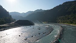
Dajia River (Chinese: 大甲溪; pinyin: Dàjiǎ Xī; Pe̍h-ōe-jī: Tāi-kah-khoe; lit. 'big shell river') is the fifth-longest river in Taiwan located in the north-central of the island. It flows through Taichung City for 142 km.[1] The sources of the Dajia are: Hsuehshan and Nanhu Mountain in the Central Mountain Range.[2] The Dajia River flows through the Taichung City districts of Heping, Xinshe, Dongshi, Shigang, Fengyuan, Houli, Shengang, Waipu, Dajia, Qingshui, and Da'an before emptying into the Taiwan Strait.[2]
The Deji Reservoir (德基水庫; Déjī Shuǐkù; 'virtuous foundation reservoir'), formed by Techi Dam, is a 592-hectare reservoir in Dajia District.[3] The reservoir provides municipal water, generates hydroelectric power, is used for recreation and prevents flooding.[3] Techi and a cascade of five other dams on the Dajia produce up to 1,100 megawatts of hydroelectric power and generate more than 2.4 billion KWh per year.[4] The other five dams in sequence from top hill are Qingshan Dam, Kukuan Dam, Tienlun Dam, Ma'an Dam and Shigang Dam.
Taiwan's Central Cross-Island Highway runs along the Dajia River from Heping to Dongshih. The Taichung Beltway begins in Fongyuan and follows the Dajia through into Cingshuei.
Incidents[]
The Dajia experiences frequent earthflows during typhoons and heavy rain, damaging homes and breaking up roads, sometimes permanently.[citation needed] In September 2008, rains from Typhoon Sinlaku resulted in storm-swollen waters which washed away supports for a section of Houfeng Bridge (which links Houli Township and Fengyuan City), leaving six people dead.[5] In June 2010, the bridge finally reopened to vehicular traffic after over NT$1.4 billion of reconstruction work.[6]
See also[]
- List of rivers in Taiwan
References[]
- ^ Philip Diller. "Taiwan Rivers and Watersheds". Retrieved 2007-11-30.
- ^ Jump up to: a b "大安大甲流域(Da-an/Dajia River Basin)" (in Chinese). Retrieved 2007-11-30.
- ^ Jump up to: a b "德基水庫(Techi Reservoir)" (in Chinese). National Taiwan Ocean University Water Resource Management Center. Archived from the original on 2010-11-19. Retrieved 2007-11-30.
- ^ 大甲溪 (PDF) (in Chinese). Taiwan Water Resources Agency. 2009-01-22. Archived from the original (PDF) on 2011-08-15. Retrieved 2013-06-25.
- ^ "Typhoon wreaks havoc during festival". Taiwan Today. 2008-09-19. Retrieved 2010-07-10.
- ^ "Traffic resumes on Taichung's Houfeng Bridge". The China Post. 2010-06-30. Retrieved 2010-07-10.
| Wikimedia Commons has media related to Dajia River. |
Coordinates: 24°20′00″N 120°33′23″E / 24.3333°N 120.5564°E

This article related to a river in Taiwan is a stub. You can help Wikipedia by . |
- Landforms of Taichung
- Rivers of Taiwan
- Taiwan river stubs