Dampierre, Aube
show This article may be expanded with text translated from the corresponding article in French. (December 2008) Click [show] for important translation instructions. |
Dampierre | |
|---|---|
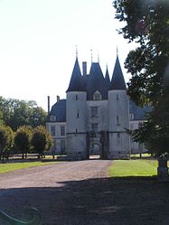 The chateau in Dampierre | |
show Location of Dampierre | |
 Dampierre | |
| Coordinates: 48°33′05″N 4°22′07″E / 48.5514°N 4.3686°ECoordinates: 48°33′05″N 4°22′07″E / 48.5514°N 4.3686°E | |
| Country | France |
| Region | Grand Est |
| Department | Aube |
| Arrondissement | Troyes |
| Canton | Arcis-sur-Aube |
| Government | |
| • Mayor (2020–2026) | Guy Boncorps[1] |
| Area 1 | 29.36 km2 (11.34 sq mi) |
| Population (Jan. 2018)[2] | 311 |
| • Density | 11/km2 (27/sq mi) |
| Time zone | UTC+01:00 (CET) |
| • Summer (DST) | UTC+02:00 (CEST) |
| INSEE/Postal code | 10121 /10240 |
| Elevation | 104–196 m (341–643 ft) (avg. 153 m or 502 ft) |
| 1 French Land Register data, which excludes lakes, ponds, glaciers > 1 km2 (0.386 sq mi or 247 acres) and river estuaries. | |


Dampierre is a commune in the Aube department in north-central France.
Population[]
| Year | Pop. | ±% |
|---|---|---|
| 1962 | 327 | — |
| 1968 | 327 | +0.0% |
| 1975 | 302 | −7.6% |
| 1982 | 320 | +6.0% |
| 1990 | 283 | −11.6% |
| 1999 | 302 | +6.7% |
| 2008 | 298 | −1.3% |
| 2012 | 292 | −2.0% |
See also[]
References[]
- ^ "Répertoire national des élus: les maires". data.gouv.fr, Plateforme ouverte des données publiques françaises (in French). 2 December 2020.
- ^ "Populations légales 2018". INSEE. 28 December 2020.
| Wikimedia Commons has media related to Dampierre (Aube). |
This Aube geographical article is a stub. You can help Wikipedia by . |
Categories:
- Communes of Aube
- Aube geography stubs