Daniels Range
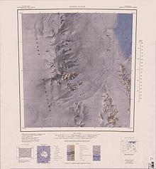
1:250,000 scale topographic map of the Daniels Range.
The Daniels Range is a principal mountain range of the Usarp Mountains, about 80 km (50 mi) long and 16 km (10 mi) wide, bounded to the north by Harlin Glacier and to the south by Gressitt Glacier. The range was mapped by USGS from surveys and U.S. Navy air photos, 1960–63. Named by US-ACAN after Ambassador (1903–86), a leading American figure in the formulation of the Antarctic Treaty in 1959. Coordinates: 71°15′S 160°00′E / 71.250°S 160.000°E

In the southern part of Daniels Range is Bounty Nunatak.
Further reading[]
- Gunter Faure, Teresa M. Mensing, The Transantarctic Mountains: Rocks, Ice, Meteorites and Water, P 110
- R. L. Oliver, P. R. James, J. B. Jago, Antarctic Earth Science, P 113
- J.W.Sheraton, R.S.Babcock, L.P.Black, D.Wyborn, C.C.Plummer, Petrogenesis of granitic rocks of the daniels range, northern victoria land, antarctica, Precambrian Research Volume 37, Issue 4, December 1987, Pages 267-286 https://doi.org/10.1016/0301-9268(87)90078-7
- R. S. Babcock C. C. Plummer J. W. Sheraton C. J. Adams, Geology of the Daniels Range, North Victoria Land, Antarctica, https://doi.org/10.1002/9781118664957.ch1
See also[]
References[]
External links[]
- Daniels Range on USGS website
- Daniels Range on AADC website
- Daniels Range on SCAR website
- Daniels Range area map
- Daniels Range current weather
This Oates Land location article is a stub. You can help Wikipedia by . |
Categories:
- Mountain ranges of Oates Land
- Oates Land geography stubs