Daymark
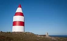
Daymark on St Martin's, Isles of Scilly


Scharhörn daymark as an illustration on a 1721 map

A daymark or a day marker is the daytime identifier (attached signboard) of an aid to navigation (ATON) or day beacon.[1]
Generally, the daymark conveys to the mariner during daylight hours the same significance as does the aid's light or reflector at night.[2]
Daymark chart symbols[]
[3][further explanation needed]
| Paper chart | Simplified | Simplified symbol name |
|---|---|---|
 |
 |
Square or rectangular daymark |
 |
 |
Triangular daymark, point up |
 |
 |
Triangular daymark, point down |
| Retro reflector |
Examples[]
In 1864, the Dart Harbour Commissioners erected a daymark at Froward Point near Kingswear in Devon. Often mistaken for a folly, it is 80 feet (24 m) high, octagonal, hollow, tapers gradually from the base to the top, has no roof and no staircase. The base has eight 30 feet (9.1 m) high pointed arches.[4]
See also[]
| Look up daymark in Wiktionary, the free dictionary. |
| Wikimedia Commons has media related to Daymarks. |
| hide | ||||||
|---|---|---|---|---|---|---|
| Types |
|  | ||||
| Fixtures | ||||||
| Maintenance | ||||||
| Locations |
| |||||
| Categories |
| |||||
| Global organizations | ||||||
| ||||||
| Authority control |
|---|
References[]
- ^ "Nautical Terms for boating and marine industry terminology". www.marineinstitute.org. Archived from the original on 2003-12-17. Retrieved 2017-03-08.
- ^ Light List, Volume II, Atlantic Coast. Washington, DC: US Government Printing Office. 2015. pp. ix.
- ^ US Chart No. 1: Symbols, Abbreviations and Terms used on Paper and Electronic Navigational Charts. Department of Commerce National Oceanic and Atmospheric Administration Department of Defense National Geospatial-Intelligence Agency. 2013. p. 86.
- ^ Headly, Gwyn (1986). Follies. Johnathan Cape. p. 19. ISBN 9780224027908.
This architecture-related article is a stub. You can help Wikipedia by . |
This lighthouse-related article is a stub. You can help Wikipedia by . |
Categories:
- Navigational aids
- Daymarks
- Architecture stubs
- Lighthouse stubs