Hailuoto
Hailuoto
Karlö | |
|---|---|
Municipality | |
| Hailuodon kunta Karlö kommun | |
 Pilot station and lighthouse in Marjaniemi | |
 Coat of arms | |
 Location of Hailuoto in Finland | |
| Coordinates: 65°01′N 024°43′E / 65.017°N 24.717°ECoordinates: 65°01′N 024°43′E / 65.017°N 24.717°E | |
| Country | |
| Region | Northern Ostrobothnia |
| Sub-region | Oulu sub-region |
| Government | |
| • Municipal manager | Ari Nurkkala |
| Area (2018-01-01)[1] | |
| • Total | 1,082.70 km2 (418.03 sq mi) |
| • Land | 200.53 km2 (77.43 sq mi) |
| • Water | 882.17 km2 (340.61 sq mi) |
| Area rank | 261st largest in Finland |
| Population (2021-03-31)[2] | |
| • Total | 953 |
| • Rank | 297th largest in Finland |
| • Density | 4.75/km2 (12.3/sq mi) |
| Population by native language | |
| • Finnish | 99.1% (official) |
| • Swedish | 0.1% |
| • Others | 0.8% |
| Population by age | |
| • 0 to 14 | 12.8% |
| • 15 to 64 | 48.4% |
| • 65 or older | 38.9% |
| Time zone | UTC+02:00 (EET) |
| • Summer (DST) | UTC+03:00 (EEST) |
| Municipal tax rate[5] | 20.5% |
| Website | www.hailuoto.fi |
| Official name | Bird Wetlands of Hailuoto Island |
| Designated | 2 February 2004 |
| Reference no. | 1505[6] |

Hailuoto (Finnish: [ˈhɑi̯ˌluo̯to]; Swedish: Karlö) is an island and a municipality in Northern Ostrobothnia region, Finland. The population of Hailuoto is 953 (March 31, 2021),[2] which make it the smallest municipality in Northern Ostrobothnia and the former Oulu Province in terms of population. The municipality covers an area of 200.53 km2 (77.43 sq mi) (excluding sea areas) of which 1.70 km2 (0.66 sq mi) is inland water (January 1, 2018).[1] The population density is 4.75/km2 (12.3/sq mi). Of all the Finnish islands in Finland's sea areas, Hailuoto is the third largest after Fasta Åland and Kimitoön.[7]
Hailuoto is located on an island of the same name opposite the city of Oulu in the Gulf of Bothnia. The distance between Oulu and Hailuoto is 53 kilometres (33 mi), and the sea area between them is called Luodonselkä (literally "the back of islet").[8] A ferry operates regularly between Hailuoto and Oulunsalo. In winter an official ice road, approximately 10 kilometres (6.2 mi) long, connects the island to the mainland.[9] The main road on the island is the regional road 816, which continue to the mainland towards the Kempele municipality via a ferry connection. Hailuoto also has a small airfield, Hailuoto Airfield, about 6 kilometres (4 mi) south of central village.[10]
Land in the region is constantly rising due to post-glacial rebound. It is estimated that the first parts of Hailuoto appeared from the Baltic Sea about 1700 years ago. The current island of Hailuoto was formed from many smaller islands. Two large sections, Santonen and Hanhinen merged into the main island (Luoto) only about two centuries ago. The island is continuously expanding and eventually it will join with the continent. Kirkkosalmi, a wetland region between Hanhinen and Luoto is renowned for being an important bird refuge where rare bird species are observed.
The theme of the coat of arms of Hailuoto describes the economy of the island municipality; the explanation of the coat of arms is "in a blue field with a silver rowlock." The coat of arms was designed by Teuvo-Pentti Pakkala and approved by the Hailuoto Municipal Council at its meeting on April 28, 1966. The Ministry of the Interior approved the use of the coat of arms on December 19 of the same year.[11][12]
History[]
The permanent settlement of Hailuoto apparently began in the 12th century. Residents came from many directions, especially from Karelia. The Swedes, who competed for its fishing waters, gave the island the name Karelö (which was transformed into Karlö), which means freely translated "Karelian Island". The first permanent residents of Hailuoto were mostly from Western Finland, but some also came from Eastern Finland. In 1548 there were 43 houses on the island, and by 1570 the number of houses had grown to 60. Queen Christina of Sweden donated the entire island of Hailuoto in 1652 to Colonel Berndt Taube, from whose heirs it was returned to the crown in 1675.[13]
Hailuoto first belonged to the high parish of Saloinen (nowadays part of Raahe), from which it separated into an independent parish in 1587.[14][15] The church, built in 1610–1620, was for a long time the oldest wooden church in use in Finland until it burned down in 1968.[16] The current church was completed in 1972.[17]
During the Great Famine of 1695–1697, 88 inhabitants of Hailuoto died.[13] During the Great Northern War (1713–1721), 200 Cossacks of the Tsardom of Russia killed about 800 people in Hailuoto with an ax on September 29, 1714. Many of the victims had sought protection on the island, as Hailuoto had a population of less than 300 at that time. The bloodshed done overnight was the greatest of the Great Northern War.[18] According to tradition, the bells of Hailuoto Church were drowned in Lake Kirkonjärvi during the Great Northern War, where they were never found again.[13]
Geography and nature[]

Hailuoto is the largest island in the Gulf of Bothnia, consisting of four parts, Luoto, Santonen, Hanhinen and Syökari. They were still separated a couple of centuries ago until they joined together as a result of crustal rebound. The young surface forms of the island are shaped throughout by sea waves, currents, ice thrust and wind.[16]
The soil consists of sandy materials, which are partly derived from clay sandstone, which is called The formation of Muhos extends to Hailuoto. A 15-kilometer-long grayling ridge runs through the island from Hyypänmäki to Marjaniemi in a north-east-southwest direction. In the eastern parts of Hyypänmäki, the meltwater of the glacier has broken up the sand into a plateau almost two kilometers wide. In the central parts, Harju runs only a few ten-meter-wide high ridges, but spreads west from Isomäki again. The quarry Marjaniemi tip is a wear residue of the heart of the ridge. The highest point is Hyypänmäki which is about 31 meters above sea level. There are also rocks in the Hyypänmäki area, which are later covered with dry quicksand. The rocks show that the waves washed the shores of the islands, but the cliff ramparts also show that the drift ice pushed violently against the shores. Aerial sand dikes and shore dikes are a special feature that characterizes the surface forms of Hailuoto, especially on the north and west coasts.[16]
The most diverse part of Hailuoto's vegetation is spread on the shores, especially in the coastal meadows of sheltered coves. In forest nature, dry pine barrens are well represented. Extensive lichen fabrics are particularly characteristic. Hailuoto, a bird research site, has a long tradition. Waterfowl are most abundant in meadows, extensive shallows, reefs and lush bays. The highlight of the fall is the migration of swans, which culminates in one and a half thousand birds resting on the shores.[16]
Islands[]
Hailuoto (main island), Hoikanriisi, Isomatala, Kengänkari, Mustakivi, Santosenkari, Pikku-Hoikka, Ulkoriisi, Ulkolaidanmatala and Väliteonkarit.
Villages[]
Järventakusta, Hailuoto, Koivukylä, Marjaniemi, Ojakylä, Pöllä, Ulkokarvo and Vaski.
Services[]
In the center village of Hailuoto there is a comprehensive school,[19] two grocery stores (K-Market and Sale), a bank (Osuuspankki), a barber shop and a filling station (SEO).[20]
The Arctic Light House Hotel for tourists is located right next to the Marjaniemi Lighthouse.[21]
Religion[]
According to the 2018 regional division, the only parishes in the municipality are the Hailuoto Parish of the Finnish Evangelical Lutheran Church[22] and the Oulu Orthodox Parish of the Finnish Orthodox Church.[23] Of the revival movements within the church, Conservative Laestadianism operates in the locality, which has the Hailuoto Peace Association (Hailuodon Rauhanyhdistys).[24]
Culture[]
The entire island of Hailuoto is classified as one of Finland's nationally significant built cultural environments.[25] The unique landscape and natural conditions have made Hailuoto, the largest island in the Bay of Bothnia, one of Finland's national landscapes.
Food[]
In the 1980s, fish potatoes made from European whitefish were named traditional food of the Hailuoto parish.[26]
Notable people[]
- Henry Askeli (1886–1962), Finnish American journalist and labor activist
- Yrjö Karilas (1891–1982), writer
Gallery[]

Tourist Info Office
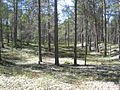
Typical forest in Hailuoto

Hailuoto Church, built in 1972

Old church, built in the 1610s, destroyed by fire in 1968
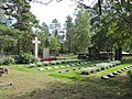
Military cemetery of Hailuoto
The ferries Meriluoto and Merisilta
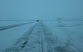
The ice road between the island and the mainland

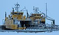
Fishing boats in Marjaniemi


See also[]
References[]
- ^ Jump up to: a b "Area of Finnish Municipalities 1.1.2018" (PDF). National Land Survey of Finland. Retrieved 30 January 2018.
- ^ Jump up to: a b "Preliminary population structure by area, 2021M01*-2021M03*". StatFin (in Finnish). Statistics Finland. Retrieved 2 May 2021.
- ^ "Population according to language and the number of foreigners and land area km2 by area as of 31 December 2008". Statistics Finland's PX-Web databases. Statistics Finland. Retrieved 29 March 2009.
- ^ "Population according to age (1-year) and sex by area and the regional division of each statistical reference year, 2003-2020". StatFin. Statistics Finland. Retrieved 2 May 2021.
- ^ "List of municipal and parish tax rates in 2021" (PDF). Tax Administration of Finland. 1 December 2020. Retrieved 10 April 2021.
- ^ "Bird Wetlands of Hailuoto Island". Ramsar Sites Information Service. Retrieved 25 April 2018.
- ^ "Suomen merialueiden sata suurinta saarta" (in Finnish). Suomen Kuvalehti. June 15, 1987. p. 64. Cite magazine requires
|magazine=(help) - ^ Facta 2001, WSOY, 1984 (in Finnish)
- ^ "Jäätie Perämeren suurimpaan saareen on taas auki – katso miltä noin 10 kilometrin jääreitti Hailuotoon näyttää ilmasta käsin" (in Finnish). Yle. 11 February 2021. Retrieved 12 February 2021.
- ^ "Hailuoto, Finland – EFHL". VFR Suomi / Finland. Vantaa: Finavia. 18 November 2010. Archived from the original on 21 April 2012. Retrieved 8 October 2020.
- ^ Suomen kunnallisvaakunat (in Finnish). Suomen Kunnallisliitto. 1982. p. 129. ISBN 951-773-085-3.
- ^ "Sisäasiainministeriön vahvistamat kaupunkien, kauppaloiden ja kuntien vaakunat 1949-1995 I:8 Hailuoto". Kansallisarkiston digitaaliarkisto (in Finnish). Retrieved March 15, 2021.
- ^ Jump up to: a b c Hannu Tarmio, Pentti Papunen & Kalevi Korpela: Suomenmaa 1: maantieteellis-yhteiskunnallinen tieto- ja hakuteos, p. 217–220. Porvoo-Helsinki: WSOY, 1967. (in Finnish)
- ^ Hailuodon historia – Luontoon (in Finnish)
- ^ Paimenmuisto: Hailuoto (Carlö, Karlö) – Kansallisbiografia (in Finnish)
- ^ Jump up to: a b c d Kalevi Rikkinen (1986). Finlandia, Otavan iso maammekirja 8 (in Finnish). Helsinki: Otava. ISBN 951-1-09142-5.
- ^ "Hailuodon seurakunta Hiski-tietokannassa" (in Finnish). Retrieved January 8, 2021.
- ^ Kaitasuo, Pia (August 15, 2015). "Pietari Suuren synkkä tuhon kylvö". Kaleva (in Finnish). No. 221. Oulu: Kaleva Oy. pp. 34–35. ISSN 0356-1356.
- ^ Comprehensive school – Hailuoto Website
- ^ Stores and other services – Hsiluoto Website
- ^ Hotel accommodation – Hailuoto Website
- ^ Yhteystiedot - Suomen evankelis-luterilainen kirkko (in Finnish)
- ^ Oulun ortodoksinen seurakunta (in Finnish)
- ^ Hailuodon Rauhanyhdistys (in Finnish)
- ^ Hailuoto - Pohjois-Pohjanmaa (in Finnish). Finnish Heritage Agency. Retrieved 8 January 2021.
- ^ Jaakko Kolmonen (1988). Kotomaamme ruoka-aitta: Suomen, Karjalan ja Petsamon pitäjäruoat (in Finnish). Helsinki: Patakolmonen. p. 168. ISBN 951-96047-3-1.
External links[]
 Media related to Hailuoto at Wikimedia Commons
- hailuototourism.fi
- Municipality of Hailuoto – Official site (in English)
 Hailuoto travel guide from Wikivoyage
- Ferry timetables (in Finnish)
- Bothnian Bay Research Station of the University of Oulu
- Live webcam from the ferry

| show Authority control |
|---|
This Oulu Province location article is a stub. You can help Wikipedia by . |
- Hailuoto
- Finnish islands in the Baltic
- Landforms of Northern Ostrobothnia
- Ramsar sites in Finland
- Cultural heritage
- Oulu Province geography stubs