Lauttasaari
Lauttasaari (Finnish: [ˈlɑu̯tːɑˌsɑːri]; Swedish: Drumsö; literally "Ferry Island") is an island in Helsinki, Finland, about 3 kilometres (1.9 mi) west of the city centre. Together with some surrounding unpopulated small islands, Lauttasaari is also a district of Helsinki. With 23,226 residents as of 2017,[1] the island is Finland's second largest by population, after Fasta Åland. Its land area is 3.85 km2.
Lauttasaari is primarily a residential area but also contains services, including several marinas and canoe clubs. Although close to the city centre, Lauttasaari has not been entirely built up. Notably, almost the entire shoreline remains in public use, with footpaths, beaches, playgrounds, patches of forest, and rocky outcrops.
The name Lauttasaari literally means "ferry island", although nowadays, the island is connected to the rest of Helsinki and to the city of Espoo by bridges, causeways, and the Helsinki metro, which has two stations in the district. The island has two postal codes: 00200 and 00210.

History[]

Lauttasaari was a largely undeveloped part of the municipality of Huopalahti (Hoplax), which was annexed to the city of Helsinki on 1 January 1946.
Transportation[]
Public transport[]
Metro[]

The Helsinki metro has two stations in the district, the Lauttasaari and the Koivusaari stations. The Lauttasaari metro station is served by two entrances: one in the Lauttis shopping centre, and one on Gyldenintie.
Bus[]
All the internal bus routes — 20, 21, and 21B — connect with at least one of the metro stations, and the routes 20 and 21 continue to the city centre. The bus routes 115A and 555 start at the centre of the island. Route 115A runs via Tapiola to Mankkaa in Espoo, and route 555 runs via Espoo to Martinlaakso in the city of Vantaa. Lauttasaari is also served by night bus routes 20N and 112N from the city centre.
Car[]
The Länsiväylä (also the National road 51) motorway that links central Helsinki with Espoo passes through Lauttasaari, and has two interchanges on the island. Espoo's side starts in the Westend district. Going towards the city center of Helsinki, the Länsiväylä will run along the Lauttasaari Bridge, which was built in late December 1969.[2] The bridge is 317 metres long and 23.5 metres wide, made of reinforced concrete, and its span is 56.6 metres.[3]
Lauttasaarentie and Lauttis[]
Lauttasaarentie is the main thoroughfare in Lauttasaari, home to many residents, and the location of the shopping mall Lauttis, which also serves as one of the entrances to the Lauttasaari metro station.[4] The shopping mall is the commercial centre of the island, and near its geographical centre.
Subdistricts[]

The district of Lauttasaari is divided into four subdistricts.[1]
Koivusaari[]
The subdistrict of Koivusaari is a separate island, separated from Lauttasaari by a narrow channel. It had no residents as of 2017.[1] Its postal code is 00200. The Koivusaari metro station was built in anticipation of extending the island by land fill and constructing residential buildings on it.
Kotkavuori[]
The subdistrict of Kotkavuori comprises the northeastern part of the island, nearest Helsinki city centre. The housing is mainly apartment buildings. The subdistrict has one of the two main hills of the island, where the iconic Lauttasaari water tower was located in 1958–2015.
Kotkavuori had 8,117 residents as of 2017.[1] Its postal code is 00200.
Myllykallio[]
The subdistrict of Myllykallio comprises the western part of the island. The housing is mainly apartment buildings. The subdistrict has one of the two main hills of the island.
The area of Katajaharju is the part of Myllykallio on the north side of Länsiväylä motorway. The housing is mainly private residential houses.
Myllykallio had 7,066 residents as of 2017.[1] Its postal code is 00200.
Vattuniemi[]
The subdistrict of Vattuniemi comprises the southern part of the island. The area was built up in the 1950s as an industrial zone. Since 2000, there has been a significant change in the makeup of the area, and several office and industrial facilities have been demolished, with apartments being built to replace them. Currently, the median price of residential property is relatively high, causing the residential makeup to consist of the young and affluent. The main streets are Särkiniementie on the western side of the area, and Vattuniemenkatu on the eastern side.
Vattuniemi had 8,043 residents as of 2017.[1] Its postal code is 00210.
Public buildings[]
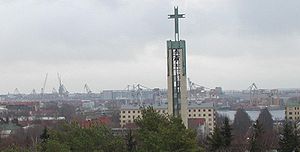
The Lauttasaari church, the Myllykallio school, and the old Management Studies Institute building are amongst the examples of 1950s construction for public spaces on the island. The church was inaugurated in 1958, and was designed by professor Keijo Petäjä, who himself was a resident of Lauttasaari. The church steeple was placed into service in the autumn of 1957.
Notable residents[]
- Zahra Abdulla (1966–), politician
- Ilkka Kuusisto (1933–), composer
- Spede Pasanen (1930–2001), comedian, director and inventor
- Sirpa Asko-Seljavaara (1939–), politician
See also[]
- Ruoholahti
References[]
- ^ a b c d e f "Statistical yearbook of Helsinki 2017" (PDF). City of Helsinki. 2017. Retrieved 13 January 2018.
- ^ Kauko Mustonen, Kalevi Pykälä: Lauttasaari : helmi Helsingin kruunussa, pp. 48–52. Lauttasaaren kustannus, 1976.
- ^ Otavan iso Fokus, volume 8, p. 4780, taulukko Suomen huomattavimpia siltoja. Otava, 1974. ISBN 951-1-02041-2.
- ^ toimitus. ""Lauttis" avautuu ensi vuonna – tältä se näyttää". Retrieved 2016-09-28.
Coordinates: 60°09′36″N 24°52′12″E / 60.16000°N 24.87000°E


- Lauttasaari