Hartola, Finland
Hartola
Gustav Adolfs | |
|---|---|
Municipality | |
| Hartolan kunta Gustav Adolfs kommun | |
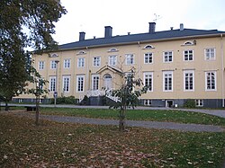 Eastern Tavastia College (Itä-Hämeen opisto) in Hartola | |
 Coat of arms | |
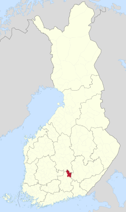 Location of Hartola in Finland | |
| Coordinates: 61°35′N 026°01′E / 61.583°N 26.017°ECoordinates: 61°35′N 026°01′E / 61.583°N 26.017°E | |
| Country | |
| Region | Päijänne Tavastia |
| Sub-region | Heinola sub-region |
| Charter | 1784 |
| Government | |
| • Municipal manager | Raija Peltonen |
| • Density | 0/km2 (0/sq mi) |
| Time zone | UTC+02:00 (EET) |
| • Summer (DST) | UTC+03:00 (EEST) |
| Website | www.hartola.fi |

Hartola (Swedish: Gustav Adolfs) is a municipality of Finland. It is located in the Itä-Häme, Päijänne Tavastia region. The municipality has a population of 2,642 (31 March 2021),[1] which make it the smallest municipality in Päijänne Tavastia in terms of population. It covers an area of 675.38 square kilometres (260.77 sq mi) of which 132.18 km2 (51.03 sq mi) is water.[2] The population density is 4.86 inhabitants per square kilometre (12.6/sq mi). Neighouring municipalities are Heinola, Joutsa, Luhanka, Pertunmaa and Sysmä.
The municipality is unilingually Finnish. The municipality is also known as "Gustav Adolfs" in Swedish.[6] Hartola is home to the , the regional museum for seven municipalities.
Since 1987, the town has billed itself as a sovereign royal parish based upon a 1784 proclamation by King Gustav III of Sweden creating a new parish on the eastern border of his kingdom in honor of his son, Gustav Adolf.
At every first Saturday in September, there is a fair at Hartola. The event is biggest in Finland at its genre.[7]
Municipality is also known about writer Maila Talvio's place of birth.
Politics[]
Results of the 2011 Finnish parliamentary election in Hartola:
- Centre Party 26.2%
- National Coalition Party 23.0%
- Social Democratic Party 18.5%
- True Finns 17.9%
- Christian Democrats 6.3%
- Left Alliance 5.0%
- Green League 1.6%
Villages[]
- Hangastaipale
- Kalho, writer Mika Waltari wrote The Egyptian here.
- Koitti
- Kuivajärvi
- Kumu
- Lepsala
- Murakka
- Nokka
- Putkijärvi
- Siltasuo
- Vuorenkylä [8] is a northernmost village in Päijänne Tavastia
All schools those located in villages have been closed. School system in Hartola is about 140 years old.[9]
Pictures from Hartola[]

References[]
- ^ Jump up to: a b c d e "Preliminary population structure by area, 2021M01*-2021M03*". StatFin (in Finnish). Statistics Finland. Retrieved 2 May 2021.
- ^ Jump up to: a b c d e "Area of Finnish Municipalities 1.1.2018" (PDF). National Land Survey of Finland. Retrieved 30 January 2018.
- ^ Jump up to: a b c d e f g h i j k l m n "Population according to language and the number of foreigners and land area km2 by area as of 31 December 2008". Statistics Finland's PX-Web databases. Statistics Finland. Retrieved 29 March 2009.
- ^ Jump up to: a b "List of municipal and parish tax rates in 2021" (PDF). Tax Administration of Finland. 1 December 2020. Retrieved 10 April 2021.
- ^ Jump up to: a b c d e "Population according to age (1-year) and sex by area and the regional division of each statistical reference year, 2003-2020". StatFin. Statistics Finland. Retrieved 2 May 2021.
- ^ Kotimaisten kielten tutkimuskeskus :: Svenska ortnamn i Finland
- ^ Infopage
- ^ http://www.vuorenkyla.fi/ Vuorenkylä cite, finnish, village was notable in 2007 village of the year
- ^ http://www.koittiry.net/riihiniemen-koulun-100-vuotisjuhla History of Riihiniemi school, finnish, citation 2012
External links[]
![]() Media related to Hartola at Wikimedia Commons
Media related to Hartola at Wikimedia Commons
- Municipality of Hartola – Official website, finnish, english
- Itä-Hämeen Museo

| Authority control |
|
|---|
- Hartola, Finland
- Populated places established in 1784