Deûle
| Deûle | |
|---|---|
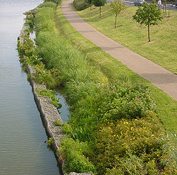 The Deûle near | |
 | |
 | |
| Location | |
| Country | France |
| Region | Hauts-de-France |
| Physical characteristics | |
| Source | |
| • location | France |
| Mouth | |
• location | Lys |
• coordinates | 50°43′52″N 2°56′41″E / 50.73111°N 2.94472°ECoordinates: 50°43′52″N 2°56′41″E / 50.73111°N 2.94472°E |
| Basin features | |
| Progression | Lys→ Scheldt→ North Sea |


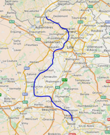
The Deûle (Dutch: Deule) is a river of northern France which is channeled for the main part of its course (from Lens to Lille). The upstream part is still partly free-flowing and is known as the Souchez. The Deûle flows into the Lys (right bank) in Deûlémont.
The Souchez is formed from the union, in the village of Souchez, of two smaller brooks, called the Carency and the Saint-Nazaire.
The channeled part comprises two branches:
- the high gauge canal known as Canal de la Deûle which ensures the connection between the channeled Lys and the Scarpe (a tributary of the Scheldt) in Douai,[1]
- the Canal de Lens,[2] fed by the Souchez,[3] which connects Lens with the Canal de la Deûle at Courrières.
Immediately downstream of Lens, the channel is unusually elevated compared to the neighboring banks, as a result of .
The Deûle flows through the departments of Pas-de-Calais and Nord, and the towns of Lens, Wingles, Loos, Lille, Wambrechies and Quesnoy-sur-Deûle, before it flows into the Lys at Deûlémont.
The Deûle does not yet profit from a .

References[]
External links[]
| Wikimedia Commons has media related to Deûle. |
- http://www.geoportail.fr
- https://web.archive.org/web/20030910115632/http://www.eau-artois-picardie.fr/edition/magazine/cc30/etude.htm (in French)
| Authority control |
|---|
- Tributaries of the Leie
- Rivers of France
- Rivers of Nord (French department)
- Rivers of the Pas-de-Calais
- Rivers of Hauts-de-France
- Hauts-de-France geography stubs
- France river stubs