De Klomp
De Klomp | |
|---|---|
Village | |
 Railway station | |
 De Klomp Location in the Netherlands | |
| Coordinates: 52°2′40″N 5°34′18″E / 52.04444°N 5.57167°ECoordinates: 52°2′40″N 5°34′18″E / 52.04444°N 5.57167°E | |
| Country | Netherlands |
| Province | Gelderland |
| Municipality | Ede |
| Area | |
| • Total | 2.44 km2 (0.94 sq mi) |
| Elevation | 8 m (26 ft) |
| Population (2021)[1] | |
| • Total | 460 |
| • Density | 190/km2 (490/sq mi) |
| Time zone | UTC+1 (CET) |
| • Summer (DST) | UTC+2 (CEST) |
| Postal code | 6745[1] |
| Dialing code | 0318 |


De Klomp is a village in the municipality of Ede, with a railway station called "Veenendaal-De Klomp railway station". It is located in the Dutch province of Gelderland.
It was first mentioned in 1787 as De Klomp, and is a name of an inn.[3] A settlement has known to exist since 1565 and mainly concentrated along the road. After World War II, industry started to settle in the village.[4]
Gallery[]

Hotel in De Klomp
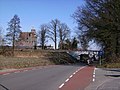
Underpass near the train station


This Gelderland location article is a stub. You can help Wikipedia by . |
- ^ a b c "Kerncijfers wijken en buurten 2021". Central Bureau of Statistics. Retrieved 22 March 2022.
- ^ "Postcodetool for 6745WB". Actueel Hoogtebestand Nederland (in Dutch). Het Waterschapshuis. Retrieved 22 March 2022.
- ^ "De Klomp - (geografische naam)". Etymologiebank (in Dutch). Retrieved 22 March 2022.
- ^ "De Klomp". Plaatsengids (in Dutch). Retrieved 22 March 2022.
Categories:
- Ede, Netherlands
- Populated places in Gelderland
- Gelderland geography stubs