Degraves Street, Melbourne
Degraves Street | |
|---|---|
 | |
Degraves Street | |
 | |
 Degraves Street | |
| Coordinates | |
| General information | |
| Type | Street |
| Location | Melbourne |
| Length | 100 m (300 ft) |
| Gazetted | 1837 |
| Tourist routes | City of Melbourne Walks: Arcades & Lanes, The Cosmopolitan |
| Major junctions | |
| North end | Flinders Lane |
| South end | Flinders Street |
| Location(s) | |
| LGA(s) | City of Melbourne |
Degraves Street is a pedestrian precinct and thoroughfare in Melbourne, Victoria, Australia. It is a short, narrow laneway in the Central Business District that runs north–south from Flinders Street to Flinders Lane and is situated in-between Swanston Street and Elizabeth Street. Degraves, as the street is colloquially known, is famous for its alfresco dining options and because it epitomises Melbourne's coffee culture and street art scene.[1] For these reasons it has also become a popular tourist destination.[2]
The street is named after Charles and William Degraves, pioneer merchants from Hobart who built a flour mill at the corner of Flinders Lane and Degraves Street in 1849.[3] William was also notably a member of the Victorian Legislative Council for fourteen years.[4]
Location[]
The cobbled bluestone alley forms a busy alternative thoroughfare for commuters disembarking from Flinders Street station toward the shopping areas of Block Arcade on Collins Street and Bourke Street Mall.
Degraves Street is often confused and therefore synonymous with Centre Place, a similar walkway situated diagonally on the other side of Flinders Lane. Degraves Street also offshoots to the east into a dead end (sharing the same name) about halfway down its length.
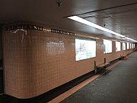
Campbell Arcade (also referred to as the Degraves Underpass) was built in the 1950s to allow pedestrians to walk from Flinders Street Station to Degraves Street underground, rather than walking across busy Flinders Street.[1] It is used by thousands of people every day.[5] The arcade is home to the Platform Artists Group who frequently exhibit artworks amongst the arcade's iconic pink tiles and black marble columns.[6]
Culture[]

Degraves features numerous bars, shops, cafes and restaurants. The art deco architecture, dining umbrellas and café canopies mean the street is often described as having a Parisian or European flavour.[7] Redevelopment of the Mutual Store in 2006 has further enhanced the lane with additional shops.
Many of the taller, older buildings were also converted into loft style apartments in the 1990s, adding further life to the area. Street art and graffiti are commonplace, whilst buskers/street performers also frequent the laneway, adding to its atmosphere.[8]
The Majorca Building, built in the 1930s, dominates the view at the northern end of Degraves Street. The building was designed by Harry Norris and is cladded in faience tiles.
Gallery[]

Degraves Street at dusk

Campbell Arcade underpass from Flinders street station with signature pink tiles

Degraves Street exit from Campbell Arcade
See also[]
- Lanes and arcades of Melbourne
- History of Melbourne
- Melbourne Walks [1]
 Australian Roads portal
References[]
| Wikimedia Commons has media related to Degraves Street, Melbourne. |
- ^ a b Terra, Monique La. "The History Of Melbourne's Degraves Street In 1 Minute". Culture Trip. Retrieved 18 January 2017.
- ^ Victoria, c=au; o=State Government of Victoria; ou=Department of Innovation, Industry and Regional Development ; ou=Tourism. "Degraves Street, Destination, Melbourne, Victoria, Australia". Tourism Victoria home. Retrieved 18 January 2017.
- ^ Hardy, Patsy. Australian Dictionary of Biography. Canberra: National Centre of Biography, Australian National University.
- ^ Victoria, corporatename=Parliament of. "Parliament of Victoria - People in Parliament". www.parliament.vic.gov.au. Retrieved 18 January 2017.
- ^ "Underground gallery relaunches as The Dirty Dozen". ABC News. 23 June 2015. Retrieved 18 January 2017.
- ^ Platform Artist Group Blog
- ^ "Degraves Espresso". City of Melbourne What's On. 18 January 2017. Retrieved 15 April 2019.
- ^ "Where to find the best street art in Melbourne". Time Out Melbourne. Retrieved 18 January 2017.
- Melbourne City Centre
- Streets in Melbourne


