Delaware Water Gap National Recreation Area
| Delaware Water Gap National Recreation Area | |
|---|---|
 Silver Thread Falls, the smaller waterfall at the Dingman's Falls site is located near Dingman's Ferry, Pennsylvania. | |
 | |
| Location | New Jersey & Pennsylvania, United States |
| Nearest city | Stroudsburg, Pennsylvania, Port Jervis, New York |
| Coordinates | 41°09′14″N 74°54′50″W / 41.15381°N 74.91388°WCoordinates: 41°09′14″N 74°54′50″W / 41.15381°N 74.91388°W |
| Area | 66,741 acres (270.09 km2)[1] |
| Established | September 1, 1965 |
| Visitors | 4,068,529 (in 2020)[2] |
| Governing body | National Park Service |
| Website | Delaware Water Gap National Recreation Area |


The Delaware Water Gap National Recreation Area is a 70,000 acres (28,000 ha) national recreation area along the middle section of the Delaware River in New Jersey and Pennsylvania stretching from the Delaware Water Gap northward in New Jersey to the state line near Port Jervis, New York, and in Pennsylvania to the outskirts of Milford. A 40-mile (64 km) section of the Delaware River within it has been granted protected status as the Middle Delaware National Scenic River under the National Wild and Scenic Rivers System and is also administered by the National Park Service. This section of the river is the core of the historical Minisink region.
Description[]
The recreation area includes parts of Sussex and Warren counties in New Jersey, and Monroe, Northampton, and Pike counties in Pennsylvania. The Appalachian Trail runs along much of the eastern boundary of the park and is maintained and updated by the New York - New Jersey Trail Conference. The park offers historical and cultural sites including the Minisink Archaeological Site, Millbrook Village, and the arts center in and rural scenery approximately an hour's drive from New York City. The park has significant Native American archaeological sites. In addition, a number of structures remain from early Dutch settlement during the colonial period. Outdoor recreational activities include canoeing, hiking, camping, swimming, cycling, cross-country skiing, horseback riding, and picnicking. Fishing and hunting are permitted in season with valid state licenses.
Geology and geography[]
History[]
Minisink[]

The Minisink (or more recently "Minisink Valley") is a loosely defined geographic region of the Upper Delaware River valley in northwestern New Jersey (Sussex and Warren counties), northeastern Pennsylvania (Pike and Monroe counties) and New York (Orange and Sullivan counties).
The name was derived by Dutch colonists from the Munsee name for the area, as bands of their people took names after geographic places which they inhabited as territory throughout the mid-Atlantic area. Originally inhabited by Munsee, the northern branch of the Lenape or Delaware Indians, the area's first European settlers arrived in the late seventeenth and early eighteenth centuries and were Dutch and French Huguenot families from colonial New York's Hudson River Valley. The term "Minisink" is not used often today. It is preserved because of its historical relevance concerning the early European settlement of the region during the American colonial period and as an artifact of the early "first contact" between Native Americans and early European explorers, traders and missionaries in the seventeenth century.[3]
Much of the historical Minisink region has been incorporated into the Delaware Water Gap National Recreation Area after defeat of a controversial dam project proposed to be built by U.S. Army Corps of Engineers on the Delaware River near Tocks Island.
Tocks Island Dam project[]
The Delaware River is prone to floods—some resulting from seasonal snow melt or rain run-off from heavy rainstorms. However, record flooding occurred in August 1955 in the aftermath of two separate hurricanes (Hurricane Connie and Hurricane Diane) that passed over the area within the span of one week. On 19 August 1955, the river gauge at Riegelsville, Pennsylvania recorded that the Delaware River reached a crest of 38.85 feet, or 16.85 feet above flood stage.
A project to dam the river near Tocks Island was in the works before the 1955 floods. But several deaths and severe damages resulting from these floods brought the issue of flood control to the national level. The U.S. Army Corps of Engineers proposed the construction of the dam, which would have created a 37-mile (60-km) long lake between Pennsylvania and New Jersey, with depths of up to 140 feet. The area around the lake would be established as the Tocks Island National Recreation Area under the oversight of the National Park Service, to offer recreation activities such as hunting, hiking, fishing, and boating. In addition to flood control and recreation, the dam would be used to generate hydroelectric power and provide a clean water supply to New York City and Philadelphia.
Starting in 1960, the present-day area of the Recreation Area was acquired for the Army Corps of Engineers through eminent domain. Approximately 15,000 people were displaced by the condemnation of personal property along the Delaware River and the surrounding area. An estimated 3,000 to 5,000 dwellings and outbuildings were demolished in preparation for the dam project and subsequent flooding of the valley. This included many irreplaceable historical sites and structures connected with the valley's Native American and colonial heritage.
Establishment of the recreation area[]
The Delaware Water Gap National Recreation Area was originally authorized by Congress in 1965 to be a narrow area surrounding the proposed reservoir,[4] in part to make the project more cost-effective.[5]
The dam project was embroiled in controversy and engendered strong opposition by environmental groups and embittered displaced residents. Because of considerable opposition from environmental activists, the unavailability of government funding for the dam, and a geological assessment revealing the dam would be located near active fault lines, the federal government decided to abandon the dam project in 1978. The lands acquired were then transferred to the National Park Service, and the holdings were added to the Delaware Water Gap National Recreation Area.[6][5][7][8]
Gallery[]

The Hog Barn at the Pennsylvania farm of artist Marie Zimmermann
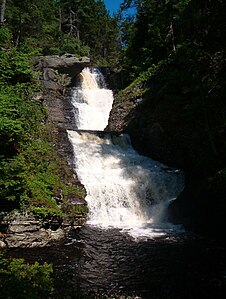
Raymondskill Falls

Dingman's Falls

Middle Delaware River above Walpack Bend
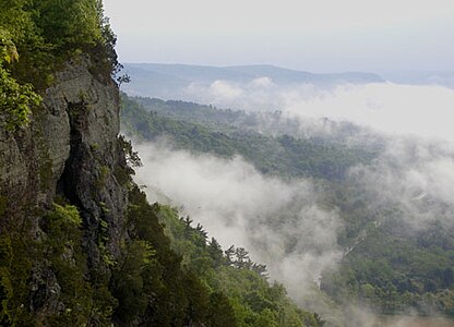
Cliffs above the Delaware River

View of Mount Tammany from Delaware Water Gap


Notable sites within the Park[]
- Brau Kettle
- Brodhead Farm
- Callahan House
- Cold Spring Farm Springhouse
- Dingman's Ferry Dutch Reformed Church
- Metz Ice Plant
- John Michael Farm
- Military Trail
- Nyce Farm
- New York - New Jersey Trail Conference
- Schoonover Mountain House
- Capt. Jacob Shoemaker House
- John Turn Farm
- Marie Zimmermann Farm
- Van Campen's Inn
- Raymondskill Falls
- Zion Lutheran Church
- List of waterfalls of the Delaware Water Gap
References[]
- ^ "Listing of acreage as of December 31, 2011" (PDF). Land Resource Division, National Park Service. Retrieved 2012-12-16.
- ^ "NPS Annual Recreation Visits Report". National Park Service. Retrieved 2012-12-26.
- ^ [1] Maps of The Minisink Valley, 1650-1783, by Peter Osborne, Minisink Valley Historical Society.
- ^ "Tocks Island Dam Controversy - Delaware Water Gap National Recreation Area". National Park Service. Retrieved 2020-12-12.
- ^ Jump up to: a b Delaware Water Gap National Recreation Area, njskylands.com.
- ^ Obiso, Laura. Delaware Water Gap National Recreation Area (2008), 7-8.
- ^ See: Feiveson, Harold; Sinden, Frank; and Socolow, Robert. Boundaries of Analysis: An Inquiry Into the Tocks Island Dam Controversy. (1976). Albert, Richard C. Damming the Delaware: The Rise and Fall of Tocks Island Dam (Pennsylvania State University Press, 1987).
- ^ "The Legacy of Tocks Island," Pocono Record, August 12, 2001
External links[]
| Wikimedia Commons has media related to Delaware Water Gap National Recreation Area. |
- National Park Service: Delaware Water Gap National Recreation Area
- The Friends Of The Delaware Water Gap National Recreation Area
| show Protected areas of Pennsylvania |
|---|
| show Authority control |
|---|
- Delaware Water Gap National Recreation Area
- National Park Service National Recreation Areas
- National Park Service Wild and Scenic Rivers
- Wild and Scenic Rivers of the United States
- Pocono Mountains
- Delaware Water Gap
- National Park Service areas in New Jersey
- National Park Service areas in Pennsylvania
- Protected areas of Sussex County, New Jersey
- Protected areas of Warren County, New Jersey
- Protected areas of Northampton County, Pennsylvania
- Protected areas of Monroe County, Pennsylvania
- Protected areas of Pike County, Pennsylvania
- Protected areas established in 1965
- 1965 establishments in New Jersey
- 1965 establishments in Pennsylvania