Spruce Knob-Seneca Rocks National Recreation Area
| Spruce Knob-Seneca Rocks National Recreation Area | |
|---|---|
 | |
 Location of Spruce Knob-Seneca Rocks National Recreation Area in West Virginia | |
| Location | West Virginia, United States |
| Coordinates | 38°50′02″N 79°22′04″W / 38.83389°N 79.36778°WCoordinates: 38°50′02″N 79°22′04″W / 38.83389°N 79.36778°W |
| Area | 100,000 acres (400 km2)[1] |
| Elevation | 1,923 ft (586 m) |
| Established | 1965-09-28 |
| Operator | Monongahela National Forest |
| Website | Spruce Knob-Seneca Rocks National Recreation Area |

Spruce Knob-Seneca Rocks National Recreation Area is a national recreation area in the Monongahela National Forest of eastern West Virginia, USA.
The National Recreation Area protects three prominent West Virginia landmarks:
- Spruce Knob, the highest point in West Virginia (and the highest of the Allegheny Mountains) with a summit elevation of 4,863 feet (1482 m).
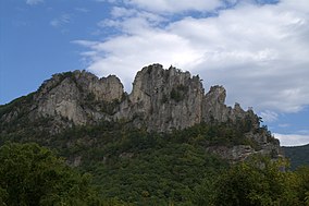
- Seneca Rocks, a 900-foot (270 m) high quartzite crag popular with rock climbers.
- Smoke Hole Canyon, a canyon along the South Branch Potomac River.
Spruce Knob-Seneca Rocks NRA was established by an act of the U.S. Congress on September 28, 1965 as the first National Recreation Area in a United States National Forest, so it is administered by the US Forest Service.
See also[]
References[]
- ^ Monongahela National Forest: Spruce Knob-Seneca Rocks National Recreation Area, accessed July 23, 2013.
External links[]
| Wikimedia Commons has media related to Spruce Knob-Seneca Rocks National Recreation Area. |
This article about a location in the Potomac Highlands of West Virginia is a stub. You can help Wikipedia by . |
Categories:
- Protected areas of Grant County, West Virginia
- National Recreation Areas of the United States
- Protected areas of Pendleton County, West Virginia
- Protected areas of West Virginia
- Protected areas established in 1965
- 1965 establishments in West Virginia
- West Virginia geography stubs
- Southern United States protected area stubs
- Potomac Highlands geography stubs