Snake Hill Wildlife Management Area
| Snake Hill Wildlife Management Area | |
|---|---|
IUCN category V (protected landscape/seascape)[1] | |
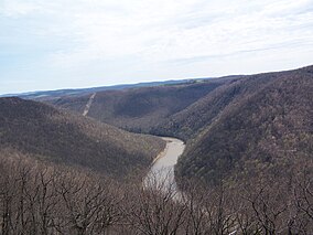 Cheat River with Snake Hill WMA on the right hillside. | |
 Location of Snake Hill Wildlife Management Area in West Virginia | |
| Location | West Virginia, United States |
| Coordinates | 39°37′45″N 79°46′36″W / 39.62917°N 79.77667°WCoordinates: 39°37′45″N 79°46′36″W / 39.62917°N 79.77667°W |
| Area | 3,092 acres (12.51 km2)[2] |
| Elevation | 1,634 ft (498 m) |
| Website | WVDNR District 1 Wildlife Management Areas |

The Snake Hill Wildlife Management Area is a hill area covering 3,092 acres (1,251 ha)[2] along the Cheat canyon (78.3-mile-long)in Monongalia and Preston Counties, West Virginia. The wildlife management area mostly lies directly south of Coopers Rock State Forest, protecting the southern side of Cheat Canyon.for many years the Canyon has been the object of controversy as environmental activists have contended with timber and development interests over the years of its preservation status.
See also[]
- Animal conservation
- Hunting
- fishing
- List of West Virginia wildlife management areas
References[]
- ^ "Snake Hill Wildlife Management Area". Protected Planet. IUCN. Retrieved 30 April 2018.
- ^ a b WVDNR District 1 Wildlife Management Areas, Accessed March 31, 2008
External links[]
This article about a location in Monongalia County, West Virginia is a stub. You can help Wikipedia by . |
Categories:
- IUCN Category V
- Wildlife management areas of West Virginia
- Protected areas of Monongalia County, West Virginia
- Protected areas of Preston County, West Virginia
- Monongalia County, West Virginia geography stubs