Ohio River Islands National Wildlife Refuge
| Ohio River Islands National Wildlife Refuge | |
|---|---|
IUCN category IV (habitat/species management area) | |
 Aerial view of one islands of the refuge | |
 Map of the United States | |
| Location | Ohio River, Kentucky, Pennsylvania, West Virginia, United States |
| Nearest city | Williamstown, West Virginia |
| Coordinates | 39°23′28″N 81°25′15″W / 39.39117°N 81.420708°WCoordinates: 39°23′28″N 81°25′15″W / 39.39117°N 81.420708°W[1] |
| Area | 3,354 acres (13.57 km2) |
| Established | 1990 |
| Governing body | U.S. Fish and Wildlife Service |
| Website | Ohio River Islands National Wildlife Refuge |

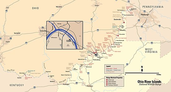
The Ohio River Islands National Wildlife Refuge (ORINWR) is a National Wildlife Refuge (NWR) in non-contiguous sites consisting of islands along 392 miles (631 km) of the Ohio River, primarily (85% of acreage)[2] in the U.S. state of West Virginia. There are also two islands upstream in Beaver County, Pennsylvania, and a pair downstream in Lewis County, Kentucky.[3] Going downstream, the refuge is currently located in parts of these counties: Beaver, Brooke, Ohio, Marshall, Wetzel, Tyler, Pleasants, Wood, Jackson, Mason, and Lewis. All counties are in West Virginia, with the exceptions in Pennsylvania and Kentucky mentioned above. The ORINWR was established in 1990 and consists of 3,354 acres (13.57 km2) of land and underwater habitat on 22 islands and four mainland properties. The refuge headquarters and visitor center is located in Williamstown, West Virginia. Prior to its establishment, West Virginia was the only state of the United States without a NWR.[citation needed]
Islands[]
The following islands in the Ohio River are part of the Ohio River Islands National Wildlife Refuge. All are in West Virginia unless indicated otherwise.
- (Pennsylvania)
- (Pennsylvania)
- Wheeling Island – part
- Captina Island
- Fish Creek Island
- Paden Island
- Williamson Island
- Witten Towhead
- Crab Island
- Wells Island
- Mill Creek Island
- Grandview Island
- Grape Island
- Middle Island
- Broadback Island
- Buckley Island
- Muskingum Island
- Neal Island – part
- Buffington Island
- Letart Island
- (Kentucky)
- (Kentucky) - part
References[]
- ^ "Ohio River Islands National Wildlife Refuge". Geographic Names Information System. United States Geological Survey.
- ^ USFWS Annual Lands Report, 30 September 2007
- ^ USFWS map
![]() This article incorporates public domain material from websites or documents of the United States Fish and Wildlife Service.
This article incorporates public domain material from websites or documents of the United States Fish and Wildlife Service.
External links[]
- Official website
- The short film Ohio River National Wildlife Refuge (2009) is available for free download at the Internet Archive
| show Protected areas of Kentucky |
|---|
| show Protected areas of Pennsylvania |
|---|
| Authority control |
|
|---|
- IUCN Category IV
- National Wildlife Refuges in Kentucky
- National Wildlife Refuges in Pennsylvania
- National Wildlife Refuges in West Virginia
- Protected areas of West Virginia
- Protected areas established in 1990
- Protected areas of Beaver County, Pennsylvania
- Protected areas of Wood County, West Virginia
- Protected areas of Wetzel County, West Virginia
- Protected areas of Tyler County, West Virginia
- Protected areas of Pleasants County, West Virginia
- Protected areas of Ohio County, West Virginia
- Protected areas of Mason County, West Virginia
- Protected areas of Marshall County, West Virginia
- Protected areas of Jackson County, West Virginia
- Protected areas of Lewis County, Kentucky
- 1990 establishments in Kentucky
- 1990 establishments in Pennsylvania
- 1990 establishments in West Virginia
- Kentucky geography stubs
- Southern United States protected area stubs
- Pennsylvania geography stubs
- Northeastern United States protected area stubs
- West Virginia geography stubs