Devil's Arrows
 | |
| Location | near Boroughbridge and Harrogate |
|---|---|
| Region | North Yorkshire, England |
| Coordinates | 54°5′34.53″N 1°24′13.25″W / 54.0929250°N 1.4036806°W |
| Type | Standing Stones |
| History | |
| Material | gritstone |
| Periods | late Neolithic or early Bronze Age |
| Site notes | |
| Condition | largely intact |
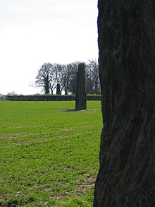
The Devil's Arrows are four standing stones or menhirs in an alignment approximately 660 feet (200 m) to the east of the A1(M), adjacent to Roecliffe Lane, Boroughbridge in North Yorkshire, England, near to where the A1 road now crosses the River Ure (grid reference SE390666). They have been designated as a scheduled monument since 1923.[1]
Site[]
Erected in prehistoric times and distinctively grooved by millennia of rainfall, the tallest stone is 22.5 feet (6.85 m) in height, making this the tallest menhir in the United Kingdom after the 25 feet (7.6 m) tall Rudston Monolith in the East Riding of Yorkshire.[2] The other two stones are 22 feet (6.7 m) and 18 feet (5.5 m) tall respectively, and it is thought that the alignment originally included up to five stones. William Camden mentions four stones in his Britannia, noting that "one was lately pulled downe by some that hoped, though in vaine, to finde treasure."[3] One was apparently displaced during a failed 'treasure hunt' during the 18th century and later used as the base for a nearby bridge over a river. The stones are composed of millstone grit, the most likely source of which is Plumpton Rocks two miles south of Knaresborough, and about nine miles from where the stones stand today.[4]
The outer stones are 360 and 200 feet (110 and 60 m) away from the central stone and form an alignment that is almost straight, running NNW–SSE. It is thought that they may have been arranged to align with the southernmost summer moonrise. The stones are part of a wider Neolithic complex on the Ure-Swale plateau which incorporates the Thornborough Henges.
Name[]


The name is mentioned by John Aubrey who visited and drew the stones in 1687.[5] There is a legend, which goes back to 1721, that says the Devil threw the stones, aiming at the next town of Aldborough. He stood on Howe Hill and shouted, "Borobrigg keep out o' way, for Aldborough town I will ding down!". However, the stones fell short and landed near Boroughbridge instead.[2]
See also[]
- Menhir
- List of menhirs
References[]
- ^ Historic England. "Stone alignment west of Boroughbridge known as the Devil's Arrows, including three standing stones and the setting for a fourth (1014705)". National Heritage List for England. Retrieved 24 November 2020.
- ^ a b "Brigantes Nation Site Report The Devil's Arrows". Archived from the original on 21 April 2008. Retrieved 18 February 2008.
- ^ "Brigantes". A Vision of Britain Through time. University of Portsmouth and others. Retrieved 25 November 2012.
- ^ "Devil's Arrows". Boroughbridge Town Council. Archived from the original on 15 February 2008. Retrieved 18 February 2008.
- ^ John Aubrey, Bodleian MS Top. Gen. C24 fol. 70r
- "Devil's Arrows". Megalithic Portal.
External links[]
| Wikimedia Commons has media related to Devil's Arrows. |
- History of North Yorkshire
- Megalithic monuments in England
- Stone Age sites in England
- Buildings and structures in North Yorkshire
- Tourist attractions in North Yorkshire
- Boroughbridge
- Archaeological sites in North Yorkshire
- Bronze Age sites in North Yorkshire
- Scheduled Ancient Monuments in North Yorkshire
- Menhirs
