List of stone circles

From Wikipedia, the free encyclopedia

A stone circle is a monument of stones arranged in a circle or ellipse. Such monuments have been constructed in many parts of the world throughout history for many different reasons. The best known tradition of stone circle construction occurred across the British Isles and Brittany in the Late Neolithic and Early Bronze Age, with over 1000 surviving examples, including Avebury, the Ring of Brodgar and Stonehenge. Another prehistoric tradition occurred in southern Scandinavia during the Iron Age, where stone circles were built to be mortuary monuments to the dead. Outside Europe, examples of stone circles include the 6300~6900 BCE Atlit Yam in Israel and 3000~4000 BCE Gilgal Refaim nearby, and the Bronze Age monuments in Hong Kong. Stone circles also exist in a megalithic tradition located in Senegal and the Gambia.[1][2]

This is an incomplete photographic list of these stone circles.

Australia[]

See also Aboriginal stone arrangement Stone circles in Australia are sometimes revered as sacred sites by the Australian Aboriginal people. While often small, there are some large stones comparable to their European counterparts, particularly in Victoria. While some are small and not well attended, others are well-known, for instance the stone arrangements in Victoria at Carisbrook and Lake Bolac.[3]

Brazil[]

See also Parque Arqueológico do Solstício.[4]

Astronomical Observatory of Calçoene


Britain, Ireland and Brittany[]

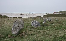
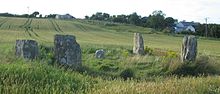
Aubrey Burl's gazetteer lists 1,303 stone circles in Britain, Ireland and Brittany. Most of these are found in Scotland, with 508 sites recorded. There are 343 on the island of Ireland;316 in England; 81 in Wales; 49 in Brittany; and 6 in the Channel Isles.[5]

Channel Islands[]

Aubrey Burl records six sites in the Channel Islands, four on Guernsey and two on Jersey. All six are Cist-in-Circle monuments, which are influenced by chambered tomb design. Their relationship with the stone circle tradition of Britain, Ireland and Brittany is unclear.[6]

Guernsey[]

LaPlatteMareCist-in-Circle sr1.jpg
La Plate Mare

Jersey[]

Dolmens La Ville ès Nouaux Saint Hélyi Jèrri.jpg
Ville-ès-Nouaux

England[]

Cornwall[]

Boscawen-Un stone circle 2011.jpg
Boscawen-Un – Stone circle with a leaning pillar in its interior.
Nine Maidens stone circle at Boskednan - geograph.org.uk - 846607.jpg
Boskednan – a partially restored stone circle near Boskednan, around 6 kilometres (4 miles) northwest of the town of Penzance.
Stone circle on Craddock Moor - geograph.org.uk - 1511039.jpg
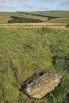
Craddock Moor – near Minions on Bodmin Moor, 800 m (12 mi) northwest of The Hurlers.
Duloe Stone Circle - geograph.org.uk - 1242170.jpg
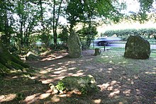
Duloe – in the village of Duloe, 8 km (5 mi) from Looe.
Stone Circle by track on King Arthur's Downs - geograph.org.uk - 29689.jpg
Emblance Downs stone circles – a pair of circles located in the parish of St. Breward on Bodmin Moor.
Stone circle near Rough Tor - geograph.org.uk - 2820042.jpg
Fernacre – located on the slopes of the De Lank River, 2 km (1+14 mi) northeast of St Breward on Bodmin Moor.
Hurlers.jpg
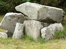
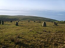
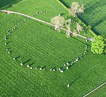
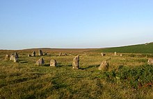
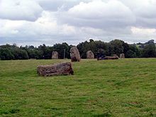
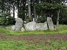
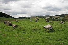
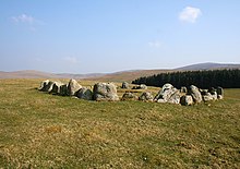
The Hurlers are a group of three stone circles on Bodmin Moor.
The Merry Maidens Penwith.jpg
The Merry Maidens – near St Buryan in West Penwith.
Nine Stones stone circle, East Moor - geograph.org.uk - 526315.jpg
Nine Stones, Altarnun – 3 km (2 mi) south southeast of Altarnun, 11 km (7 mi) west of Launceston on Bodmin Moor.
Stone Circle with modern china clay works. - geograph.org.uk - 418770.jpg
Stannon – near St Breward on Bodmin Moor.
Tregeseal east towards carn kenidjack.jpg
Tregeseal East – also known as the Tregeseal Dancing Stones, near St Just in West Penwith.
Trippet Stones - geograph.org.uk - 3273960.jpg
Trippet stones – Manor Common in Blisland, 9 km (5.6 mi) north northeast of Bodmin on Bodmin Moor.

Cumbria[]

Birkrigg stone circle.JPG
Birkrigg – Two non-concentric circles, 3 km (2 mi) south of Ulverston: grid reference SD 29247396
Stone Circle - geograph.org.uk - 1175177.jpg
Brat's Hill – The largest of the Burnmoor stone circles: 1.6 km (1 mi) south of Boot.
Castlerigg.jpg
Castlerigg – A 33-metre-diameter (108 ft) ring consisting of 38 stones.
Gamelands stone circle 1.JPG
Gamelands – Near Orton, Eden: grid reference NY640081.
Kinninside Stone Circle - geograph.org.uk - 1125881.jpg
Kinniside – A reconstructed stone circle of 11 stones, grid reference NY060140.
LongMegAndHerDaughters(SimonLedingham)May2005.jpg
Long Meg and Her Daughters – Around 51 stones set in an oval shape measuring 100 m (330 ft) on its long axis.
Stone Circle - geograph.org.uk - 1174563.jpg
Low Longrigg circles – Two of the Burnmoor stone circles: 2 km (1 mi) south of Boot.
Cairn circle, Oddendale - geograph.org.uk - 2400493.jpg
Oddendale – Part of the Shap Stone Avenue monuments: (grid reference NY59201290).
Swinside (p4160146).jpg
Swinside – A near perfect circle located in Lake District.
Stone circle on White Moss - geograph.org.uk - 746574.jpg
White Moss stone circles – Two of the Burnmoor stone circles: 1.6 km (1 mi) south of Boot.

Derbyshire[]

Arbor low 274167 560a8cc3.jpg
Arbor Low – near Youlgreave in Derbyshire.
Stone circle and cairn - geograph.org.uk - 1214808.jpg
Barbrook One – on Ramsley Moor in the Peak District: grid reference SK27857558.
Doll Tor.JPG
Doll Tor – near Birchover in Derbyshire.
Hordron Edge stone circle - geograph.org.uk - 1365389.jpg
Hordron Edge – on the edge of Moscar Moor: grid reference SK2152486851.
Nine Ladies.JPG
Nine Ladies – Nine stones located on Stanton Moor.
Nine Stone Close - geograph.org.uk - 59755.jpg
Nine Stones Close – between Alport and winster: grid reference SK225626.

Devon[]

Stone Circle at Brisworthy - geograph.org.uk - 9820.jpg
Brisworthy stone circle
Grey Wethers 14(1).JPG
Grey Wethers stone circles
Ringmoor Down Circle.jpg
Ringmoor Down
Scorhill.jpg
Scorhill
Shovel Down Stone Row - geograph.org.uk - 1513000.jpg
Shovel Down
Yellowmead circles - Dartmoor - geograph.org.uk - 21344.jpg
Yellowmead stone circle

Dorset[]

KingstonRussellStoneCircleC.jpg
Kingston Russell – An 18-stone Bronze Age circle near Abbotsbury. 50°41′18.7″N 2°35′56.2″W / 50.688528°N 2.598944°W / 50.688528; -2.598944
Part of the Rempstone stone circle in birch woodland, Purbeck - geograph.org.uk - 25149.jpg
Rempstone stone circle – a damaged stone circle near Corfe Castle in Dorset. It is located next to the B3351 road on the Isle of Purbeck: grid reference SY994820.
NinestonesdorsetC.jpg
The Nine Stones – A small nine stone circle near Winterbourne Abbas.

Lancashire[]

Cheetham Stone Circle.jpg
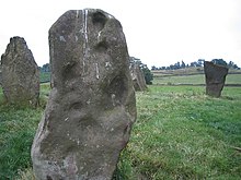
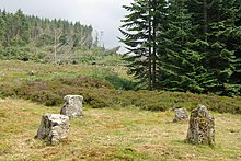
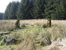
Cheetham Close – Image of one of the remaining stones at this Druidic, Bronze Age site on the picturesque moors of Egerton, Bolton.

Northumberland[]

Duddo Stone Circle - geograph.org.uk - 1729405.jpg
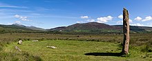
Duddo Five Stones – 6 km (4 mi) south of the Scottish border, formerly known as the Four Stones.
The Goatstones - geograph.org.uk - 1138462.jpg
The Goatstones – a Bronze-age four-poster near the village of Wark on Tyne.

Oxfordshire[]

Rollright Stones (96100107).jpg
The King's Men – one of three monuments that make up the Rollright Stones, found near the village of Long Compton.

Shropshire[]

Mitchell's Fold - 2004-10-30.jpg
Mitchell's Fold – A 30 stone ring (15 still standing).

Somerset[]

Large stones, some lying and some standing on end in grassy area.
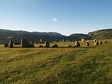
Stanton Drew – One of three circles located near the village of Stanton Drew.
Stone Circle on Withypool Hill - geograph.org.uk - 53966.jpg
Withypool Stone Circle – Located on the Exmoor moorland, near the village of Withypool. Only the stones present on the two ends of the circle are visible.

West Yorkshire[]

The Twelve Apostles of Ilkley Moor Stone Circle - geograph.org.uk - 12971.jpg
Twelve Apostles, West Yorkshiregrid reference SE12614506

Wiltshire[]

Avebury henge and village UK.jpg
Avebury – A large stone circle surround the village of Avebury.
Stonehenge Total.jpg
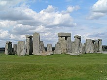
Stonehenge – A World Heritage site.

Northern Ireland[]

Down[]

Ballynoe (25), September 2009.JPG

Fermanagh[]

Drumskinney Stone Circle NE 2012 09 21.jpg
Drumskinny stone circle

Tyrone[]

Co.Tyrone, Beaghmore.jpg
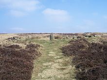
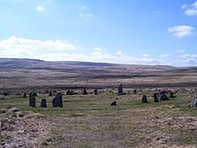
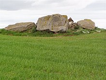
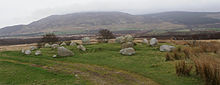
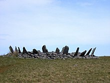
Beaghmore – Located outside Cookstown. Seven circles, along with cairns and stone rows. One circle, known as the Dragon's Teeth, is filled with more than 800 small stones.

Republic of Ireland[]

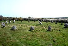
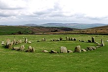
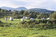
There are 187 stone circles in the Republic of Ireland. The vast majority of these are in County Cork, which has 103 circles. There are 20 circles in County Kerry and 11 in County Mayo.[7] There is also a large fully intact stone circle in Grange in County Limerick, near Lough Gur[8]Grange[9]

Cork[]

Ardgroom SW (v707553).jpg
Ardgroom SW – Known locally as "Canfea", located southwest of the village of Ardgroom on the Beara peninsula.
Breeny More Stone Circle
Carrigagulla 03.jpg
Carrigagulla – About 18 stones located to the north of the village of Ballinagree.
Carrigaphooca stone circle – 3 stones located next to Carrigaphooca Castle.
Derreenataggart Stone Circle - geograph.org.uk - 268505.jpg
Derreenataggart stone circle
DrombegStoneCircle 2004.jpg
Drombeg stone circle – Located west of Rosscarbery.
Kealkill Stone Circle (geograph 3325717).jpg
Kealkill stone circle – Located overlooking Bantry Bay.
Knocknakilla 0535.jpg
Knocknakilla – Located between Macroom and Millstreet.
Glantane Stone Circle.jpg
Glantane east – Located between Macroom and Millstreet.
Templebryan 1.jpg
Templebryan Stone Circle – Located between Bandon and Millstreet.

Donegal[]

Beltany stone circle.jpg
Beltany stone circle

Kerry[]

Kenmare Stone Circle - geograph.org.uk - 1444795.jpg
Kenmare stone circle
Lisseyviggeen (998906).jpg
Lissyvigeen stone circle
Shronebirrane Stone Circle - geograph.org.uk - 262694.jpg
Shronebirrane stone circle

Scotland[]

Aberdeen City[]

Tyrebagger Stone Circle - geograph.org.uk - 257895.jpg
Tyrebagger stone circle grid reference NJ 85950 13217.

Aberdeenshire[]

Cullerlie-Circle.jpg
Cullerlie stone circle near Echt, Aberdeenshire.
Aquhorties Recumbent.jpg
Easter Aquhorthies recumbent stone circle, near Inverurie, Aberdeenshire.
Standing Stones - geograph.org.uk - 356742.jpg
Kirkton of Bourtie recumbent stone circle, Aberdeenshire: grid reference NJ 80091 24883.
View over the recumbent of Hill of Fiddes Stone Circle - geograph.org.uk - 929287.jpg
Hill of Fiddes recumbent stone circle, Aberdeenshire: grid reference NJ 9350 2432.
Inschfield Stone Circle with Dunnideer behind - geograph.org.uk - 929294.jpg
Inschfield recumbent stone circle, Aberdeenshire: grid reference NJ 6233 2934.
Daviot.jpg
Loanhead of Daviot recumbent stone circle, Aberdeenshire.
Loudon Wood Stone Circle - geograph.org.uk - 256267.jpg
Loudon Wood recumbent stone circle, Aberdeenshire: grid reference NJ 96105 49740.
Midmar stone circle. - geograph.org.uk - 74032.jpg
Midmar Kirk recumbent stone circle, Aberdeenshire: grid reference NJ 69940 06493.
Old Keig Stone Circle - geograph.org.uk - 455962.jpg
Old Keig stone circle, Aberdeenshire: grid reference NJ 5965 1939.
Recumbent Stone - geograph.org.uk - 507718.jpg
New Craig recumbent stone circle, Aberdeenshire: grid reference NJ 7455 2966.
The Nine Stanes - geograph.org.uk - 30403.jpg
The Nine Stanes, Aberdeenshire: grid reference NO 7233 9122.
Temple Stones, Potterton - geograph.org.uk - 1174622.jpg
Potterton recumbent stone circle, Aberdeenshire: grid reference NJ95291636.
Leylodge Stones - geograph.org.uk - 1412800.jpg
South Ley Lodge recumbent stone circle, Aberdeenshire: grid reference NJ76671325.
St Brandan's Stanes - geograph.org.uk - 686298.jpg
St Brandan's Stanes, Aberdeenshire: grid reference NJ60756105.
Strichen stone circle. - geograph.org.uk - 1527074.jpg
Strichen stone circle, Aberdeenshire: grid reference NJ9367454479.
Whitebrow stone circle viewed from the sou'west - geograph.org.uk - 1709042.jpg
Stonehead recumbent stone circle, Aberdeenshire: grid reference NJ60102869.
Sunhoney stone circle - geograph.org.uk - 74031.jpg
Sunhoney, Aberdeenshire: grid reference NJ7159205701.
Whitehill Stone Circle - geograph.org.uk - 1204274.jpg
Tillyfourie recumbent stone circle, Aberdeenshire: grid reference NJ64311350.
Tomnaverie.jpg
Tomnaverie recumbent stone circle, Aberdeenshire.

Angus[]

Balkemback-01.jpg
Balkemback stone circle, Tealing: grid reference NO38183844.
Colmeallie.jpg
Colmeallie stone circle, grid reference NO56567811.

Argyll and Bute[]

Cultoon stone circle - geograph.org.uk - 112430.jpg
Cultoon stone circle, Islay: grid reference NR19565697.
Stone Circle near St Colmac Farm - geograph.org.uk - 1314389.jpg
Ettrick Bay stone circle, Bute: grid reference NS0443466794.
Stone Circle at Lochbuie - geograph.org.uk - 394251.jpg
Lochbuie stone circle, Mull: grid reference NM6178025117.
Temple wood 2006.jpg
Temple Wood stone circles, grid reference NR82639782.

Dumfries and Galloway[]

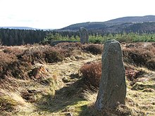
Aubrey Burl lists 43 stone circles in Dumfries and Galloway: 15 in Dumfriesshire; 19 in Kirkcudbrightshire; and 9 in Wigtonshire.[7] The Royal Commission on the Ancient and Historical Monuments of Scotland records 49 stone circles in the region. Of these 49, 24 are listed as 'possible'; one is an 18th-century construction; and a number have been destroyed.[10]

The Girdle Stanes stone circle - geograph.org.uk - 819407.jpg
The Girdle Stanes Near Eskdalemuir:grid reference NY2535196153
Stone Circle south of Old Military Road - geograph.org.uk - 1290115.jpg
Glenquicken Near Creetown:grid reference NX50965821
The Lochmaben Stone - geograph.org.uk - 1055490.jpg
Lochmaben Stone Just south of Gretna
The Loupin' Stanes stone circle - geograph.org.uk - 811307.jpg
The Loupin Stanes Near Eskdalemuir:grid reference NY25709663
Seven Brethren stone circle - geograph.org.uk - 996688.jpg
Seven Brethren Near Lockerbie: grid reference NY21718269
The Standing Stones of Glenterrow - geograph.org.uk - 586547.jpg
Standing Stones of Glenterrow Between Stranraer and New Luce:grid reference NX14536251
For wiki 1.jpg
Twelve Apostles Stone Circle, situated between Holywood and Newbridge, near Dumfries.
Torhouse Stone Circle 20080423.jpg
Torhouskie
Whitcastles Stone Circle - geograph.org.uk - 2165337.jpg
Whitcastles stone circle 10.5 km (6+12 mi) northeast of Lockerbie: grid reference NY 2240 8806

North Ayrshire[]

The Royal Commission on the Ancient and Historical Monuments of Scotland records 20 stone circles in North Ayrshire, all on Arran.[11] Five of these are listed as 'possible'.[11] Aubrey Burrel's gazetteer records 19 stone circles on Arran.[7]

Auchagallon Cairn - geograph.org.uk - 3557388.jpg
Auchagallon Stone Circle Arran grid reference NR89283464
Aucheleffan Standing Stones - geograph.org.uk - 904665.jpg
Aucheleffan Arran grid reference NR 9784 2505
Machrie Stone Circle 1 2012.jpg
Machrie Moor 1 Arran grid reference NR9119832393
Standing stones on Machrie Moor - geograph.org.uk - 799916.jpg
Machrie Moor 2 Arran grid reference NR9113032420
Machrie Stone Circle 3 2012.jpg
Machrie Moor 3 Arran grid reference NR9100632457
Machrie Stone Circle 4 2012.jpg
Machrie Moor 4 Arran grid reference NR9100132355
Machrie Moor Stone Circles - Circle 5.jpg
Machrie Moor 5 Arran grid reference NR9087832353
Machrie Stone Circle 11 2012.jpg
Machrie Moor 11 Arran grid reference NR9121232416

Orkney[]

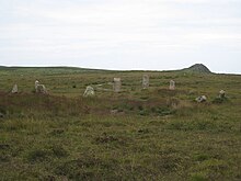
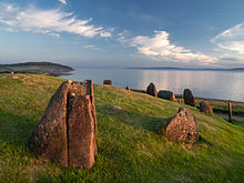
There are two stone circles on Orkney, both on the Mainland.[12] The Royal Commission on the Ancient and Historical Monuments of Scotland records a possible third at Stoneyhill, also on the Mainland.[13]

Brodgar.jpg
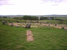
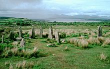
Ring of Brodgar – A 60 stone ring (27 still standing).
Standing Stones of Stenness, Aug 2014.jpg
Standing Stones of Stenness, Orkney

Perth and Kinross[]

Croft Moraig Stone Circle - geograph.org.uk - 550696.jpg
Croft Moraig – 6 km (4 mi) southwest of Aberfeldy, Scotland (grid reference NN79754726).

Scottish Borders[]

The Royal Commission on the Ancient and Historical Monuments of Scotland records 16 stone circles in the Scottish Borders. Of these, three are marked as 'possible'.[14] Aubrey Burl's gazetteer lists the same number: 2 in Berwickshire; 2 in Peebleshire; 10 in Roxburghshire; and 2 in Selkirkshire.[7]

Five Stanes Stone Circle - geograph.org.uk - 51427.jpg
Five Stanes grid reference NT75261686
Stone circle at Kirkurd - geograph.org.uk - 656034.jpg
Harestanes grid reference NT12404432
Nine Stones Stone Circle - geograph.org.uk - 378417.jpg
Ninestane Rig

Shetland[]

Aubrey Burl's gazetteer lists seven sites in Shetland, but notes that all are dubious.[15] The Royal Commission on the Ancient and Historical Monuments of Scotland records three stone circles.[16] It does not include Hjaltadans, which is instead categorised as a 'stone setting'.[17]

Hjaltadans.jpg
Hjaltadans Fetlar

Stirling[]

Stone circle near Kinnell house - geograph.org.uk - 1210724.jpg
Killin – at the western end of Loch Tay (grid reference NN576327).

Western Isles[]

Lewis[]
Callinish.jpg
Callanish I Lewis.
Cal2b.jpg
Callanish II Lewis, a smaller stone circle.
Calanais III.jpg
Callanish III Lewis, a smaller stone circle.
Cal4m.jpg
Callanish IV Lewis, a smaller stone circle.
CalanishVIII25.jpg
Callanish VIII Lewis, a smaller stone semicircle.
North Uist[]
Pobull Fhinn 20090608 from the east.jpg
Pobull Fhinn North Uist, grid reference NF8427465010.

Wales[]

Stone circle on Moel Ty-uchaf - geograph.org.uk - 385370.jpg
Moel Tŷ Uchaf Llandrillo, Denbighshire. 52°55′N 3°24′W / 52.92°N 3.40°W / 52.92; -3.40
Bryn Cader Faner stone circle - geograph.org.uk - 185579.jpg
Bryn Cader Faner, Gwynedd 52°53′54″N 4°00′41″W / 52.8982°N 4.0114°W / 52.8982; -4.0114
Bryn Gwyn stones, small adult leaning on slab stone, 11102009.JPG
Bryn Gwyn stones, Anglesey 52°53′54″N 4°00′41″W / 52.8982°N 4.0114°W / 52.8982; -4.0114

Bulgaria[]

Cromlech near Dolni glavanak 039.jpg
Dolni Glavanak Cromlech (8th-7th century BCE)

Morocco[]

Morocco Mzoura Stone Circle (2).JPG
Mzoura Cromlech (5th to 4th century BC)

Japan[]

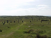
The Ōyu Stone Circles (大湯環状列石 Ōyu Kanjyō Resseki) is a late Jōmon period (approx. 2,000 – 1,500 BC) archaeological site in the city of KazunoAkita Prefecture, in the Tōhoku region of northern Japan. The site consists of two large stone circles located on an artificially flattened plateau on the left bank of the Oyu River, a tributary of the Yoneshiro River in northeastern Akita Prefecture. The site was discovered in 1931, with detailed archaeological excavations taking place in 1946, and in 1951–1952.

The larger circle, named the “Manza” circle has a diameter of 46 meters, and is the largest stone circle found in Japan. A number of reconstructions of Jomon period dwellings have been built around the site. The slightly smaller circle, named the “Nonakado” circle, is 42 meters in diameter and is located around 90 meters away, separated from the “Manza” circle by Akita Prefectural Route 66. Each circle is made from rounded river stones brought from another river approximately 7 kilometers away. Each circle in concentric, with and inner and an outer ring separated by an open strip approximately 8 meters wide.[18] Each circle contains smaller clusters of stone, including standing stones surrounded by elongated stones in a radiating orientation, forming a sundial which points toward the sunset on the summer solstice and allows for calculation of the winter solstice, the vernal equinox and the sun's movements.[19]

Each circle is surrounded by the remains of buildings, storage pits and garbage dumps, and clay figurines, clayware and stoneware (including everyday pottery), stone swords and objects have been discovered. Although the form of the stone circles made have been based on the shape of circular settlements, there is no indication of permanent settlement on the site.

The site has been submitted for inscription on the UNESCO World Heritage List as one of the Jōmon Archaeological Sites in Hokkaidō, Northern Tōhoku, and other regions.

Poland[]

Poland Odry - stone ring.jpg
Odry – Odry in Poland.

Syria[]

Gilgal Refa'im - Rujm el-Hiri.JPG
Rujm el-Hiri (4~3000 BCE) – Located northeast of the Sea of Galilee.

See also[]

References[]

  1. ^ McIntosh, Susan Keech; McIntosh, Roderick J. (1993). "Field survey in the tumulus zone of Senegal". The African Archaeological Review. 11–11: 73–107. doi:10.1007/BF01118143. S2CID 129660313.
  2. ^ Parker, Henry (1923). "Stone Circles in Gambia". The Journal of the Royal Anthropological Institute of Great Britain and Ireland. 53: 173–228. doi:10.2307/2843758. JSTOR 2843758.
  3. ^ Long, A. & Schell, P., 1999, Lake Bolac stone arrangement (AAV 7422-394); management plan. An unpublished report to Aboriginal Affairs Victoria.
  4. ^ "Agence France Presse (AFP)". doi:10.1163/9789004337862_lgbo_com_010242. Cite journal requires |journal= (help)
  5. ^ Aubrey, Burl (2000). The Stone Circles of Britain, Ireland and Brittany. New Haven; London: Yale University Press. p. 395. ISBN 978-0300083477.
  6. ^ Burl, Aubrey (2000). The Stone Circles of Britain, Ireland and Brittany. New Haven; London: Yale University Press. pp. 403. ISBN 978-0300083477. The Stone Circles of Britain, Ireland and Brittany.
  7. ^ a b c d Burl, Aubrey (2000). The Stone Circles of Britain, Ireland and Brittany. New Haven; London: Yale University Press. pp. 394. ISBN 978-0300083477. The Stone Circles of Britain, Ireland and Brittany.
  8. ^ Prendergast, Frank (2015-07-10). "The Great Stone Circle (B) at Grange, Co. Limerick". Journal of Skyscape Archaeology. 1 (1): 65–92. doi:10.1558/jsa.v1i1.26955. ISSN 2055-3498.
  9. ^ George., Roche, Helen. Eogan (2004). From megaliths to metal : essays in honour of George Eogan. Oxbow Books. ISBN 1-84217-151-8. OCLC 56955668.
  10. ^ "Canmore Advanced Search: Stone Circle: Dumfries and Galloway". Retrieved 2014-12-31.
  11. ^ a b "Canmore Advanced Search: Stone Circle: North Ayrshire". Retrieved 2015-03-19.
  12. ^ Burl, Aubrey (2000). The Stone Circles of Britain, Ireland and Brittany. New Haven: Yale University Press. p. 210.
  13. ^ "Canmore: Stoneyhill". Retrieved 2015-03-19.
  14. ^ "Canmore Advanced Search: Stone Circle: Scottish Borders". Retrieved 2014-12-31.
  15. ^ Burl, Aubrey (2005). A Guide to the Stone Circles of Britain, Ireland and Brittany. New Haven; London: Yale University Press. p. 214.
  16. ^ "Canmore Advanced Search: Stone Circle: Shetland Islands". Retrieved 2015-01-12.
  17. ^ "Canmore: Fetlar, Gravins, Fidler's Crus". Retrieved 2015-01-12.
  18. ^ Naumann, Nelly (2000). Japanese Prehistory: The Material and Spiritual Culture of the Jōmon Period. Asien-und Afrika-Studien der Humboldt-Universitat zu Berlin (Book 6). Harrassowitz Verlag. pp. 36–37. ISBN 3447043296.
  19. ^ Habu, Junko (2000). Ancient Jomon of Japan. Cambridge University Press. p. 184. ISBN 0521776708.

External links[]

Retrieved from ""